Stub: Atlas of Drylands Design
Award of Excellence
Research
Yuliang Jiang, Student ASLA; Jing Wu, Student ASLA; Ai-Ju Liu, Student ASLA; Yihe Wang, Student ASLA; Xiaolu Song, Student ASLA; Shuwei Liu; Runhao Zhu, Student ASLA; Jiayu Liang, Student ASLA; Clara Yoshihara, Student ASLA; Yashoda Godhani, Student ASLA; Sneha Ravani, Student ASLA
Faculty Advisors: Hadley Arnold
University of Southern California

In the context of global warming and increasing scarcity of water, the designers investigated and documented hydrological solutions from historically arid landscapes around the world to around the world to develop ways of addressing expected water shortfalls in Los Angeles. This proposal explored the feasibility of not only aqueducts and stepwells, but also tinajas (wilderness water bowls), yakhchals (Persian ice storage containers), and other examples from pre-industrial civilizations. By looking at ancient technologies, this project created the space for expanded thinking on the cultivation of water resources and possible interventions along the Los Angeles River.
- 2020 Awards Jury
Project Credits
Mapping Advisor, Arid Lands Institute
Peter Arnold
Drawing Advisor
Vedi Vartani
Project Statement
Eleven students set out to retrieve, document, and analyze the world’s traditional water systems. The first goal was to study how these systems functioned physically, how they operated socially, and how they organized landscapes and societies spatially. The second was to imagine new variations of these old systems and test them on the urban landscapes of water-stressed Los Angeles. The premise? By building a richer, more robust lexicon of pre-carbon drylands design systems, we might build capacity, in ourselves and others, for inspired design vision in a post-carbon world.
Project Narrative
In 2014, the Intergovernmental Panel on Climate Change (IPCC) of the United Nations made a special report (IPCC, 2014: Climate Change 2014: Synthesis Report, R.K. Pachauri et al eds) for policymakers. The report addresses the impacts of global warming of 1.5 ºC above pre-industrial levels and related global greenhouse gas emissions.
The report identifies impacts of climate change: “…will amplify existing risks and create new risks for natural and human systems. Risks are unevenly distributed and are generally greater for disadvantaged people and communities in countries at all levels of development” (page 64, in “IPCC, 2014: Climate Change 2014: Synthesis Report”). It also emphasizes the need for mitigation and adaptation to limit climate change impacts: “Adaption and mitigation are complementary strategies for reducing and managing the risks of climate change. Substantial emissions reductions over the next few decades can reduce climate risks in the 21st century and beyond, increase prospects for effective adaptation, reduce the costs and challenges of mitigation in the longer term and contribute to climate-resilient pathways for sustainable development” (page 17, in IPCC, 2014, Synthesis Report).
Because a reallocated hydrologic sphere is the principal manifestation of a warmer climate, water security (providing adequate supply and safety from flooding) is a critical adaptation challenge globally. In arid regions, water-stressed cities operate within a fragile nature-human bounded system: obtaining clean water has become the primary concern in the context of global warming. Arid cities, historically, are repositories of thousands of years of adaptive design: no-carbon water systems designed to mitigate drought and aridity, provide stable food systems, while shaping space and social systems for sharing scarce water resources. To better understand how future water systems can be designed to serve people, justice, ecosystems in the face of climate stress, we decided to investigate historical water systems and ask what value they may have as low-carbon mitigation and adaptation strategies.
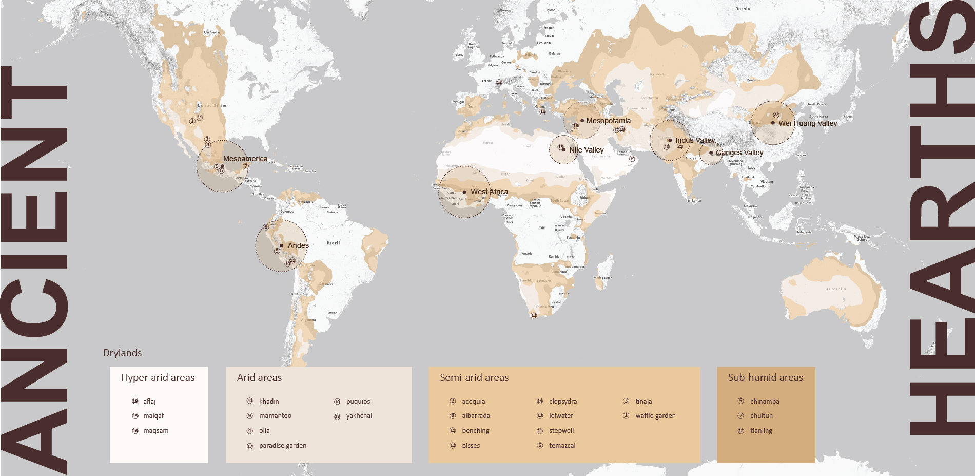
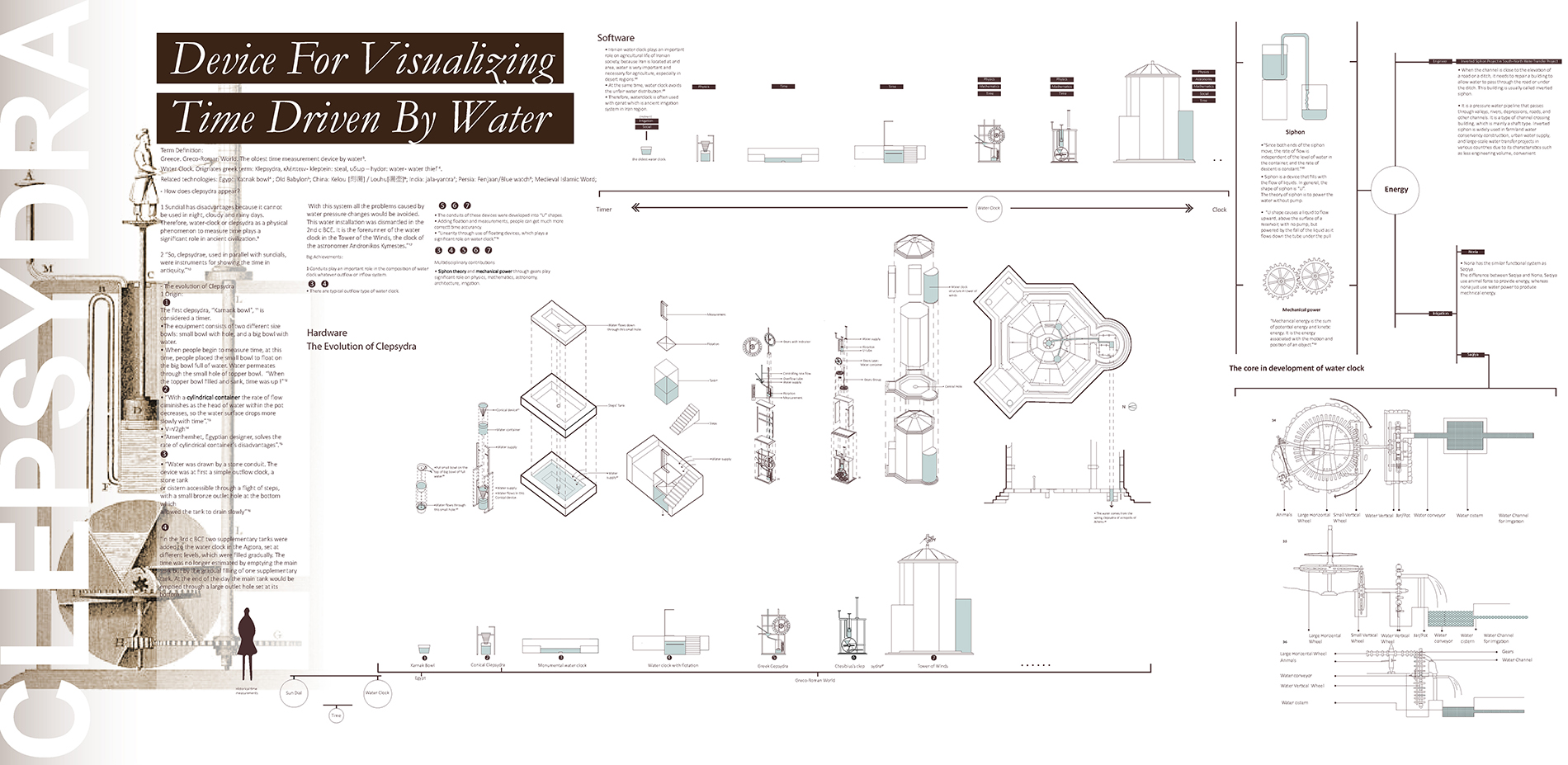
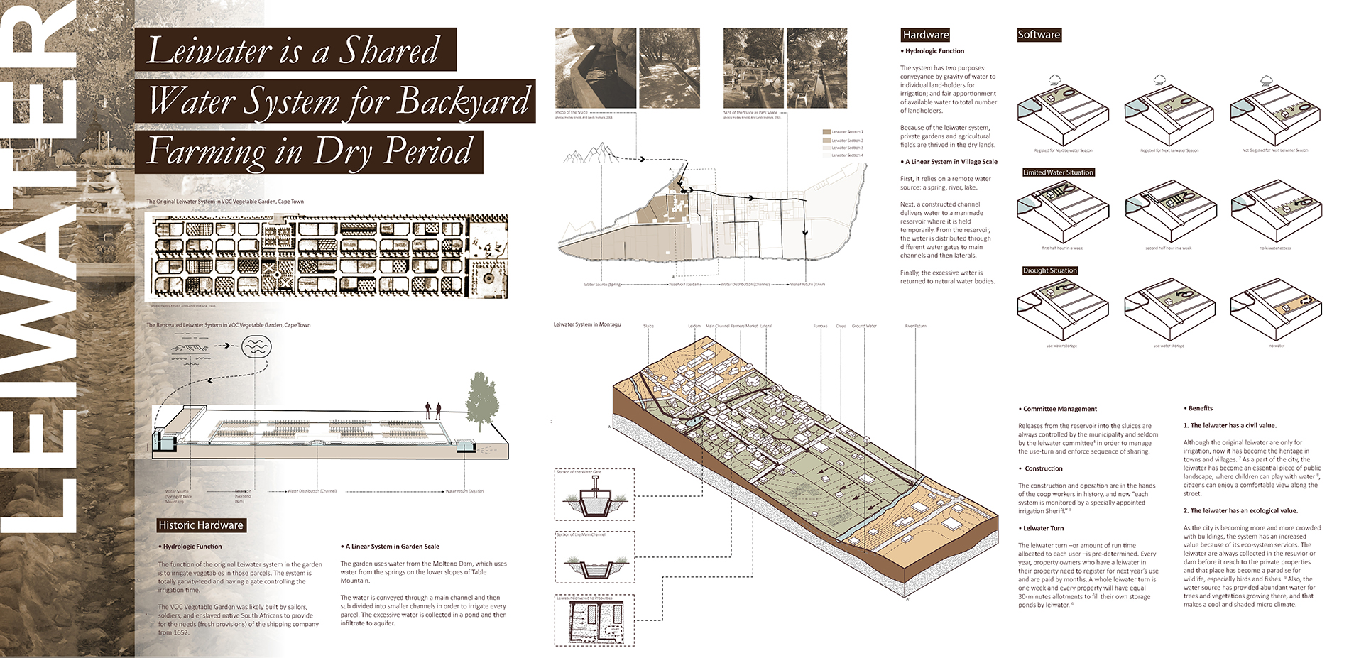
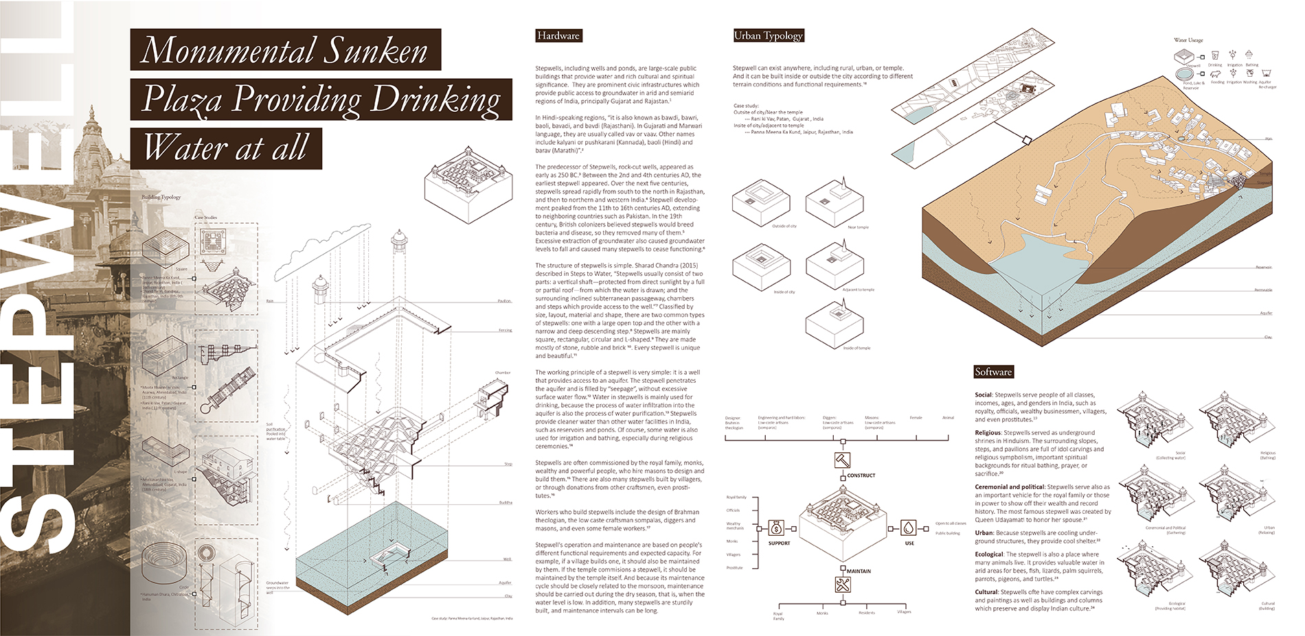
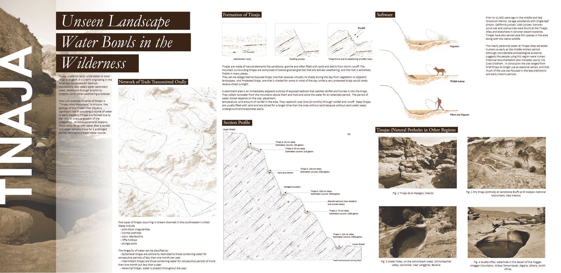
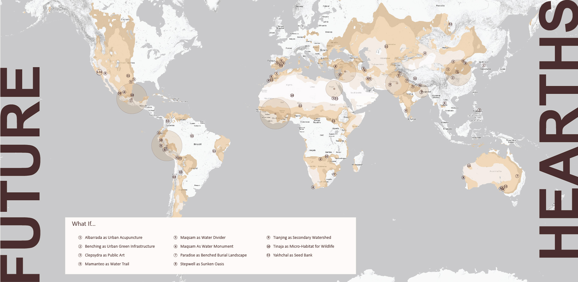
We assembled a quick world tour through ab-anbar, acequia, aflaj, ahars, ak-chin, albarradas, apodyterium, bisses, bund, caballeria, canoa, cesme, chultun, clepsydra, cuchacuchas, ejido, flume, ha-it, hammam, impluvium, jala durga, karizs, khet-tara, kudiaramaths, leiwater, maqsam, nag-kud, noria, nym-phaeum, ojos, olla, paradisos, patio, phiale, puquios, pynes, qanat, rill, runnel, saqiya, shadouf, sinnor, specchie, stepwell, sterna, temazcales, tanbur, tanque, tinaja, wadi, weir, and zanja.
Given the limitations of time, each student researched two systems to start a stub or framework for an evolving atlas. Many of the systems emerged from archeological and anthropological sites in the world’s ancient cultural hearths. We began by researching location, time period, cultural context; the meaning(s) behind the system’s name; the combination of hydrologic functions performed (catchment/ filtration/storage/distribution). We also studied whether these water systems arose independently or evolved from other systems in the global family-tree of hydrologic design.
In a literature review, we compared various resources to understand where and how comparable data had been assembled elsewhere. As a group, we studied “Out of Water: Design Solutions for Arid Regions. Liat Margolis and Aziza Chaouni. Birkhäuser, 2015.” as a precedent however, its emphasis is on the contemporary interpretation of ancient systems. “Lo-Tek: Design by Radical Indigenism, Julia Watson. Taschen, 2020” offered inspiration across cultures and affirmed a portion of our hypothesis. “Only a silver of the technologies that existed at the time of the Enlightment were valued and shepherded through to the present. Meanwhile, an alternative mythology of technology has been with us well before the Enlightment. It is unacknowledged, existing at the far ends of the Earth, with its contributors deemed primitive for centuries. While ‘modern’ societies were trying to conquer Nature in the name of progress, these indigenous cultures were working with it” (page 17, “Lo-Tek: Design by Radical Indigenism”, Julia Watson, Taschen, 2020).
Lo-Tek, while kindred, did not share our tight focus on design for water supply in drylands. We saw an opportunity to build a fuller spectrum of drylands water systems. Within our focus on ancient drylands systems from various cultural backgrounds, we found limited English resources available. However, some papers published in International conferences become valuable for us as we developed our research—for instance, the series of quadrennial Memorial CIGR (Commission Internationale du Génie Rural) World. These papers are particularly useful for students when they are studying both mechanical and social solutions of systems such as the aflaj. Even so, few scholarly resources employ design as a lens for analysis or a purpose for possible application. Our goal was to assemble documentation and tie it to spatial, formal, material, systems analysis in a visually compelling, intelligible, and actionable, way.
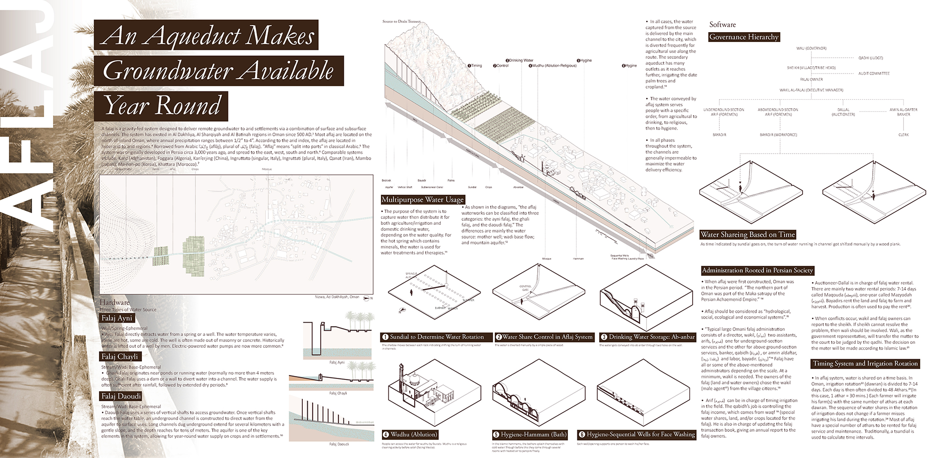
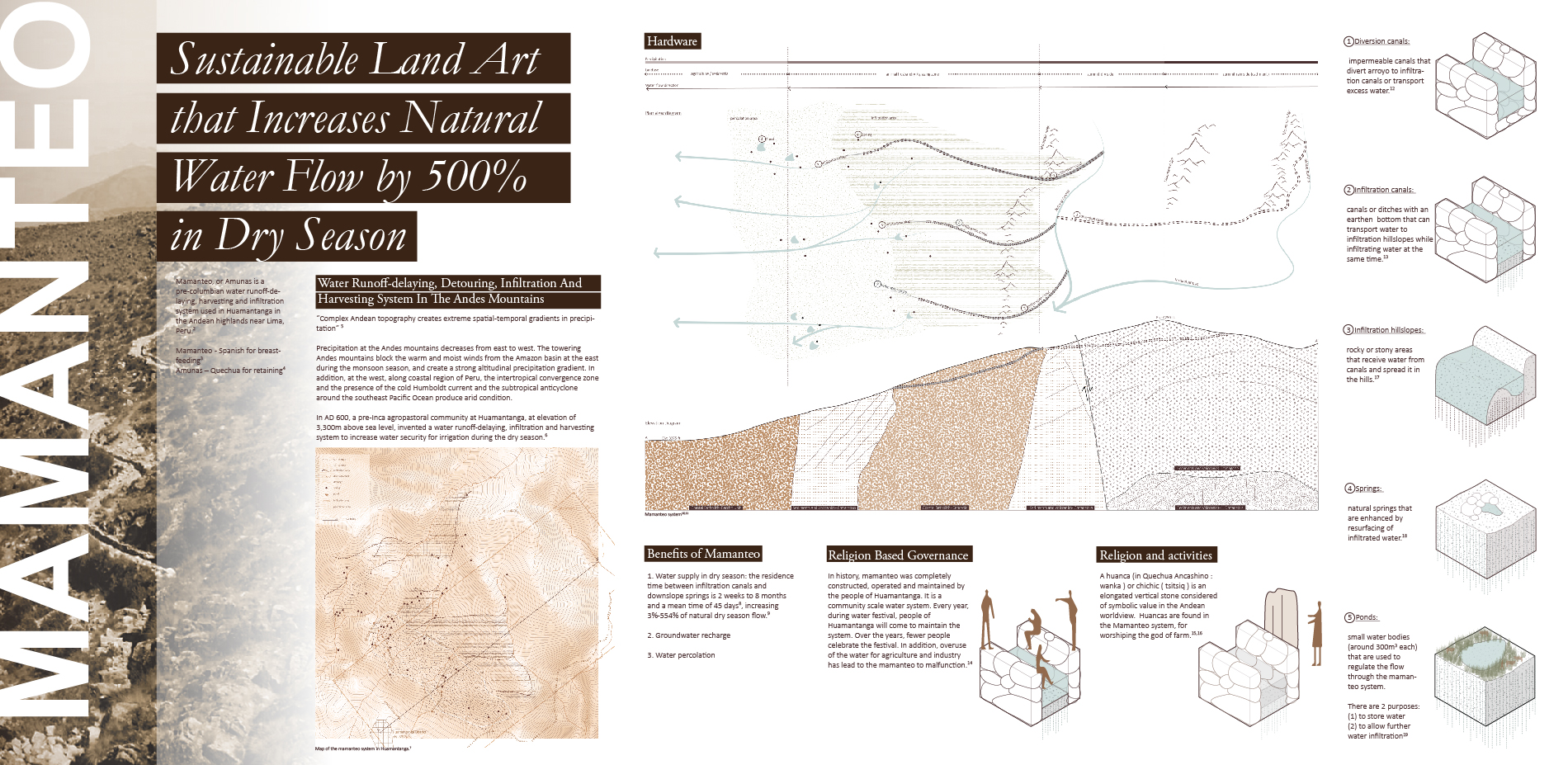
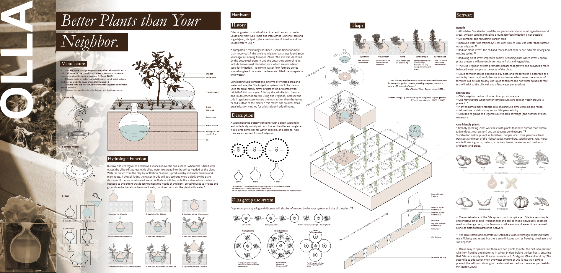
We broke down each coupled human-natural system, asking: What’s the hardware? How does this work physically? and What’s the software? (How is this managed and governed, socially? And what is the spatial and social result of that coupled system
“‘Hardware’ we described through plan, section, detail, and contextual axonometric drawings, standardized to reveal both continuities and departures across systems. Patterns emerged. Systems adhered to a basic typology of archetypes: vessel, line, field, device, and building. Within types, stunning alignments of form (see linear systems) appeared across discontinuous geographies, cultures, and time periods.
‘Software’ was harder—to both understand and to draw. What were the social systems behind construction, operation, and maintenance? How was each system governed? By what principles was water shared? How were water rights not just devised by abstract social and power relations, but written and built into the design of systems? What were the mechanisms for negotiating or overcoming water stress? Did operational rules change in times of water-plenty vs. water-scarcity? Who benefited? Typologies of governance emerged here, too, of course: from the imperial to the cooperative to the d-i-y.” *
We inquired about water systems through a series of methods. Firstly, reading. We have assembled documentation from maps, photos, journals, archeologists, and anthropologists. Secondly, documentary drawing. We have adopted a standardization of viewpoint: sectional axonometric to examine the “hardware”. The last but not the least, analytical drawing. We diagrammed the operational systems across scales and social orders to illustrate the “software”.
In terms of physical typologies, we have identified similarity across discontinuous geography/chronology. For example, we realized that for linear systems aflaj and puquios, they share the idea of tapping groundwater through the underground channel and for conveyance to the villages for consumption; they belong to a larger family of comparable systems including bisses, leiwater, acequias, and others. As far as sociological typologies as are concerned, we documented a wide spectrum, from informal, private, do-it-yourself, to collaborative/cooperative/democratic to public patronage/centralized.
We also asked, who cares? Or who could benefit? We examined how other audiences/disciplines/sectors might benefit from examining and/or re-purposing these works—from travelers to educators, to public utilities, to NGOs, and to fellow students.
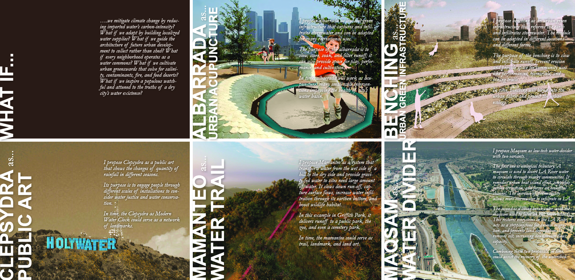
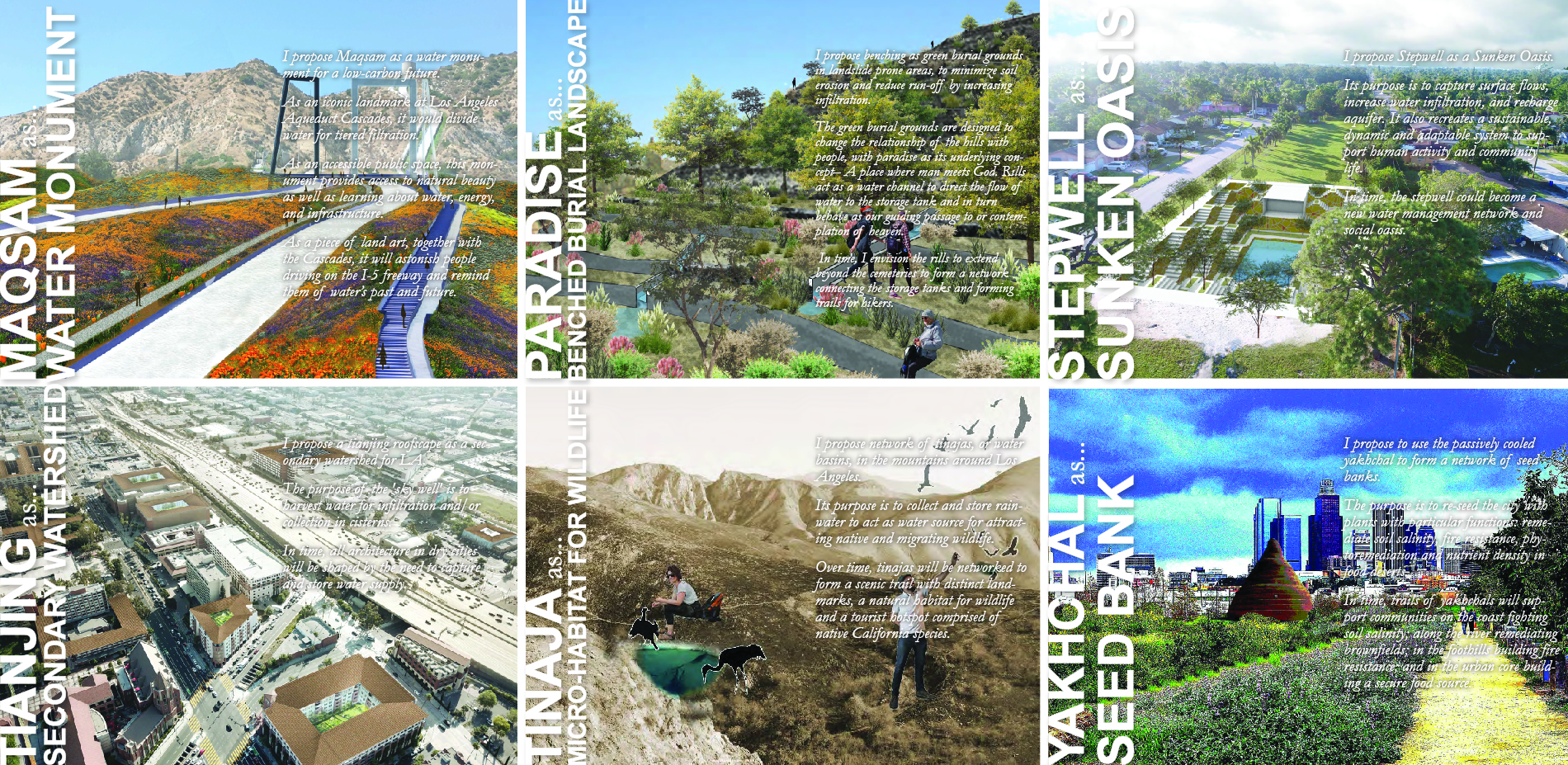
As designers, we questioned whether these ancient systems could help us to re-integrate water systems into social and spatial practices. This began the testing phase of the research: hypothetical propositions for the contemporary city, ranging from separating water from energy to localizing food production and/or creating public space around drought-tolerant fire-resistant botanical palette, with applications on every continent.
This emerging atlas testifies to the relevance of pre-carbon water systems, technologies, devices, and spaces, as well as the software of water principles behind conceiving, operating, and managing them. It could be an asset for various publics responding to water stress in the face of climate change—diversely, rapidly, and effectively.
As the research evolves, we recognize there is continued work to do around environmental metrics: for example, to measure and assess the degree to which a mesh of mamanteo trails or web of yakchal seed banks might produce measurable increase in healthy and just urban watershed function, at reduced carbon levels, with quantifiable economic benefits. We leave the questions of metrics, assessment, quantification open, for now. That work will wait. This is just a beginning.*
*Citations omitted to preserve anonymity; available upon request.