.webp?language=en-US)


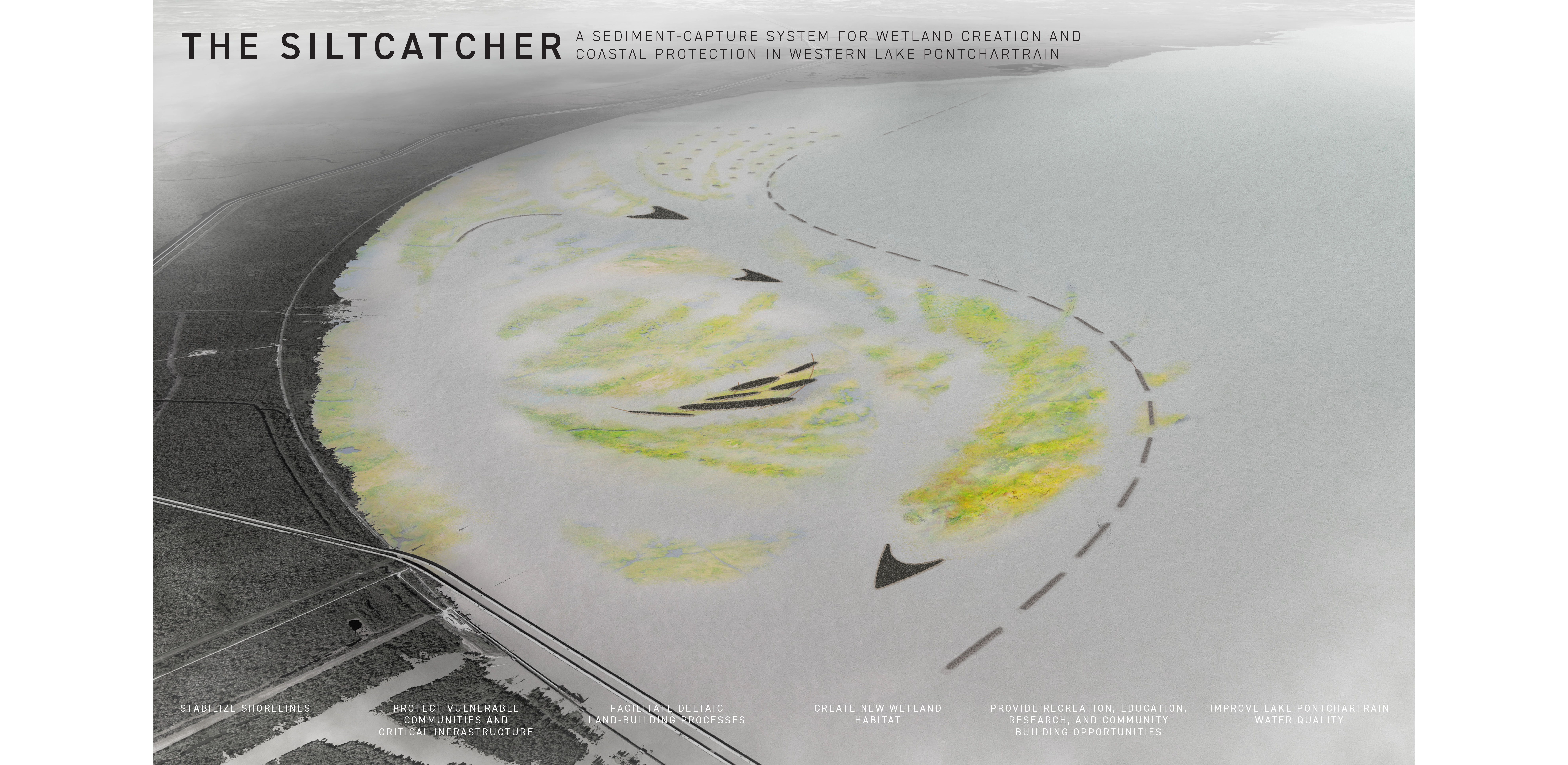
The Siltcatcher: A Sediment-Capture System for Wetland Creation and Coastal Protection in Western Lake Pontchartrain
Andrew Wright, Student ASLA
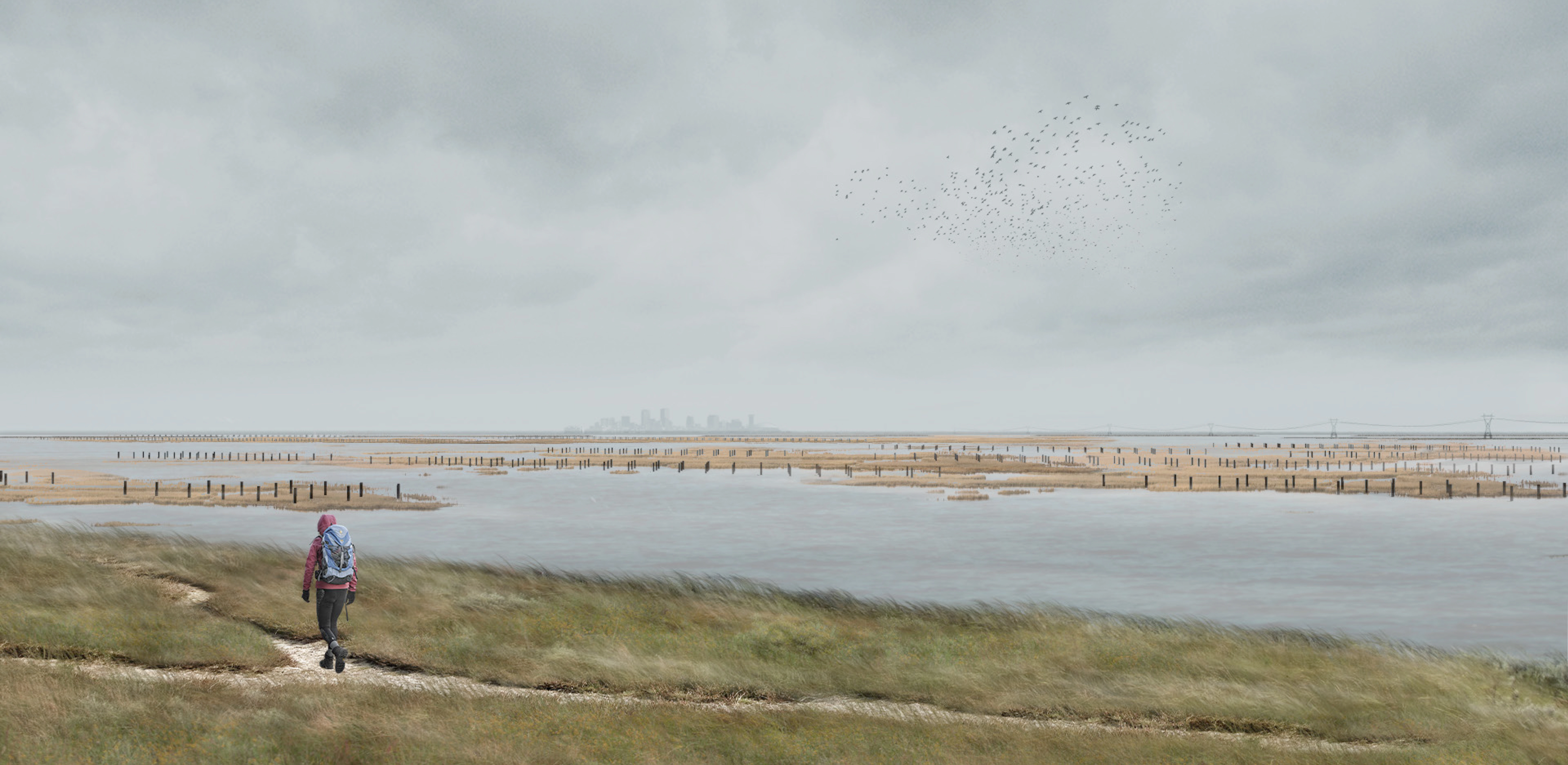
Over the last decade, Louisiana’s Lake Pontchartrain has seen its composition shift dramatically in the wake of several openings of the Bonnet Carré Spillway, which releases floodwaters from the Mississippi River into the lake. Through extensive modeling and iterative testing, the designers developed a system of breakwaters and landforms designed to catch sediment and establish wetland habitats as a natural barrier against sea level rise. Additional interventions include fields of pilings to support osprey nests and boardwalks, and stacks of oyster shells bundled together to become breakwaters. As silt accumulates around these pilings and breakwaters, it will slowly become land, adding a protective layer to a deteriorating coastline while affording recreational space for vulnerable communities.
Awards Jury
-
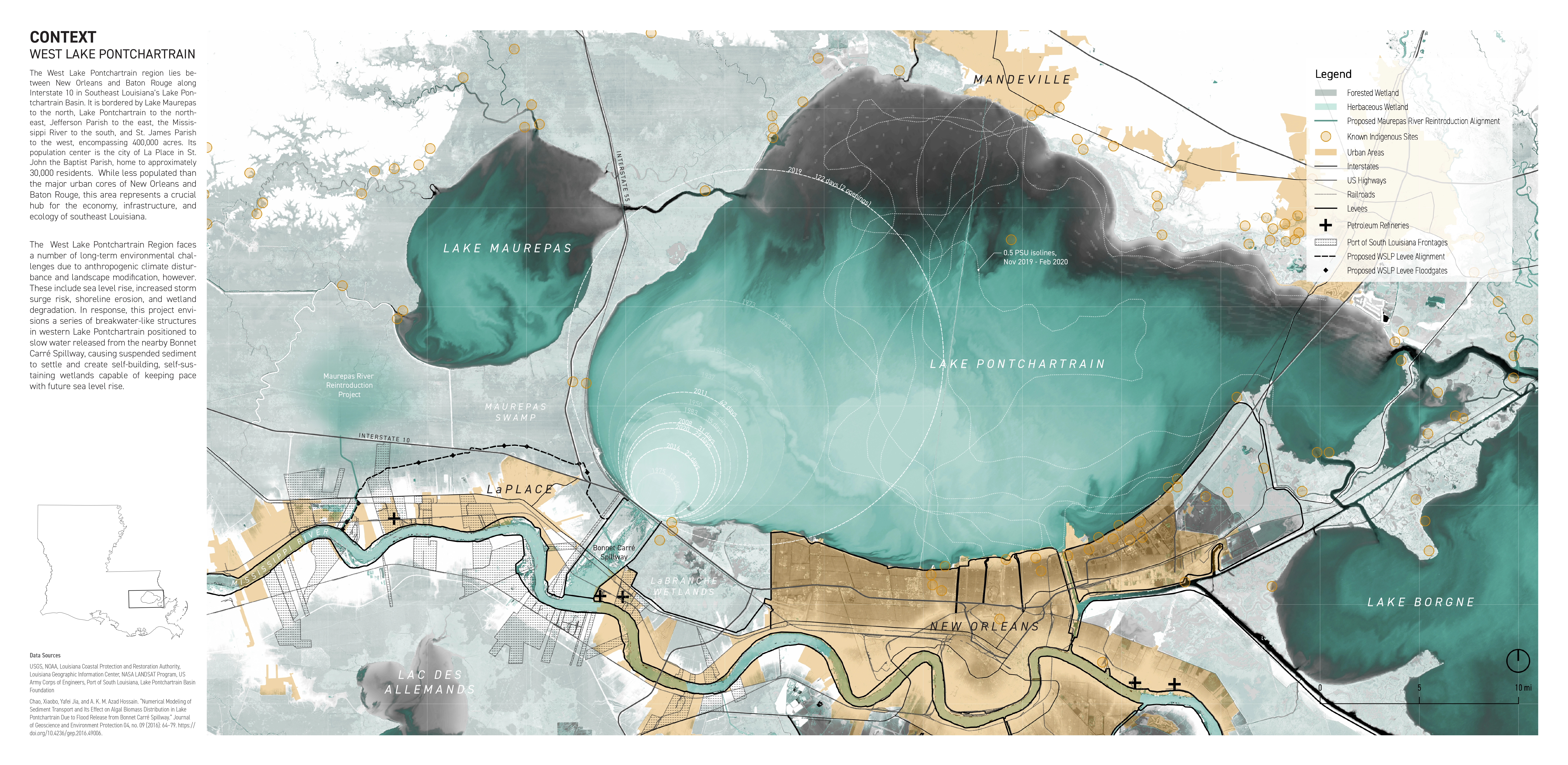
The West Lake Pontchartrain region in southeast Louisiana is home to vast wetlands, sprawling infrastructure, significant industry, and approximately 70,000 residents, many of whom are members of disadvantaged and vulnerable communities. This region faces a number of long-term environmental challenges due to climate change and anthropogenic landscape modification, including shoreline retreat, wetland degradation, subsidence, sea level rise, and increased storm surge risk. In response, the Siltcatcher proposes harnessing deltaic land building processes and sediment-laden discharge from the Bonnet Carré Spillway to create a system of self-sustaining armored wetlands in Lake Pontchartrain capable of keeping pace with sea level rise, providing long-term shoreline stabilization, habitat creation, storm surge mitigation, and recreational, educational, and community-building opportunities for nearby residents. Developed using hydrodynamic modeling as an iterative design tool, the project fuses landscape architecture and civil engineering methodologies and demonstrates the value of interdisciplinary thinking. The resulting proposal reverses conventional narratives of erosion and loss and instead creates a space where the life-giving poetry of deltaic land creation could be witnessed, enjoyed, and celebrated.
-
CONTEXT
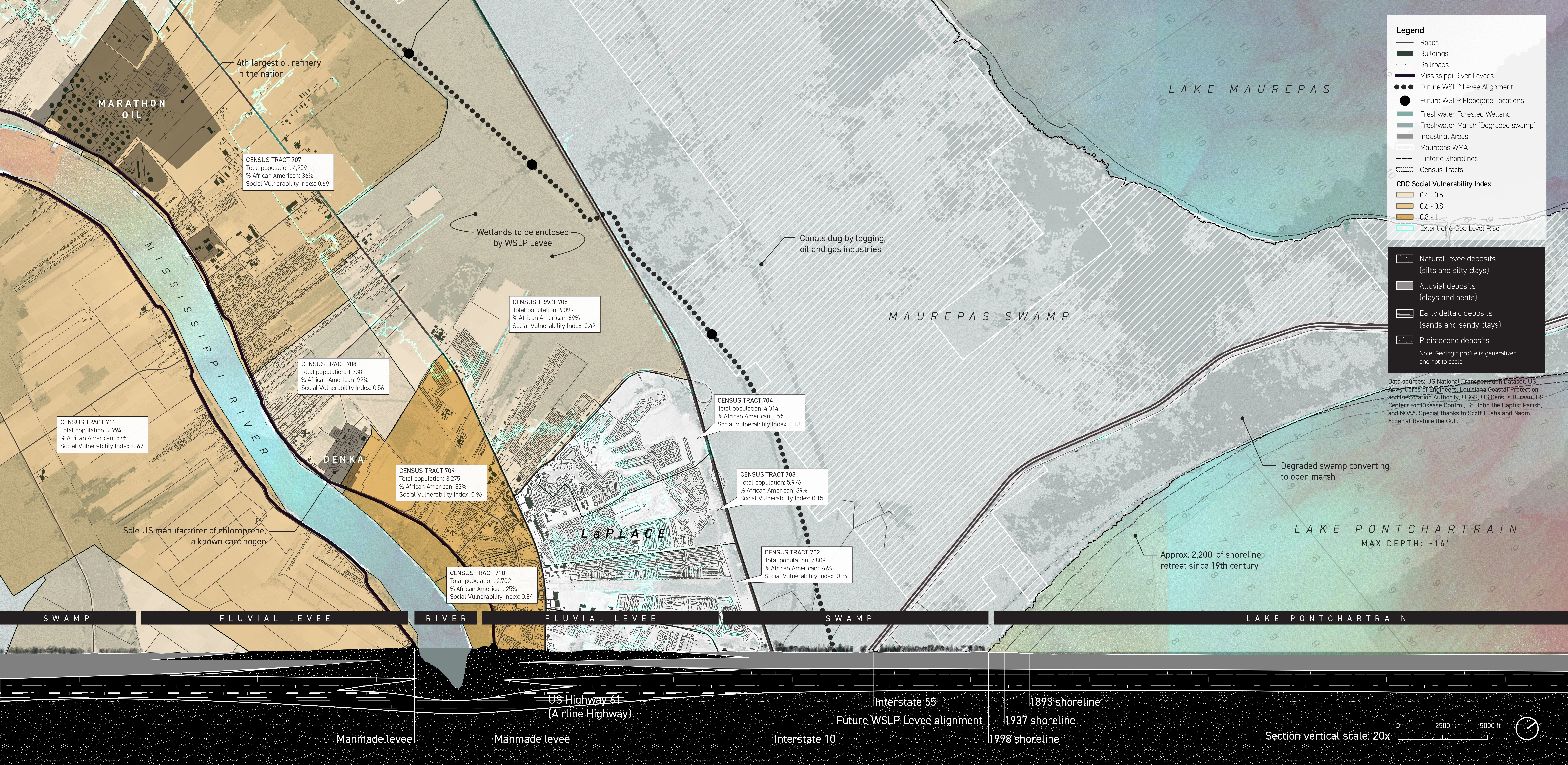
The West Lake Pontchartrain region is a key ecological, economic, and infrastructural hub for Southeast Louisiana and the nation at large. It sits at the western end of Lake Pontchartrain, a nationally significant tidal estuary, and encompasses the 125,000-acre Maurepas Swamp, the second largest freshwater forested wetland in Louisiana. It is home to a number of major industrial facilities, including one of the largest oil refineries by output in the nation, and the Port of South Louisiana, the largest port in the Western Hemisphere by tonnage. It is accessed via Interstates 10 and 55, important links in the nation’s surface transportation infrastructure and vital evacuation routes for residents of the Greater New Orleans Area.
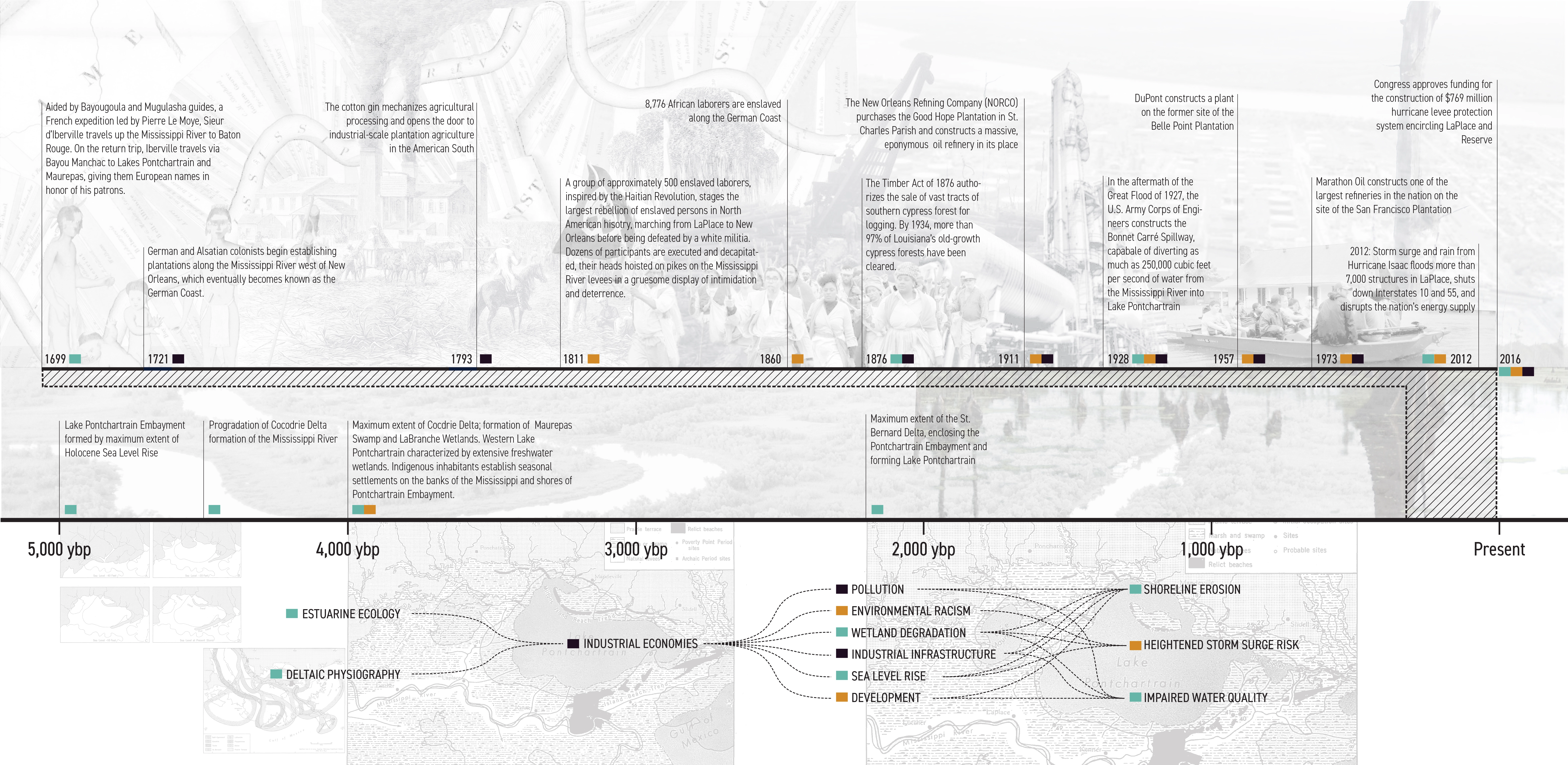
The region is also home to approximately 70,000 residents, many of whom are members of disadvantaged or otherwise vulnerable communities. LaPlace, the region’s largest population center, is 50.5% African American, and includes a number of census tracts ranked as highly at-risk by the CDC Social Vulnerability Index. These communities have lower rates of educational attainment and employment and larger percentages of residents living in poverty than neighboring majority-white communities, reflecting the pervasive and lingering impact of the region’s history of race-based enslavement, segregation, and institutional discrimination.
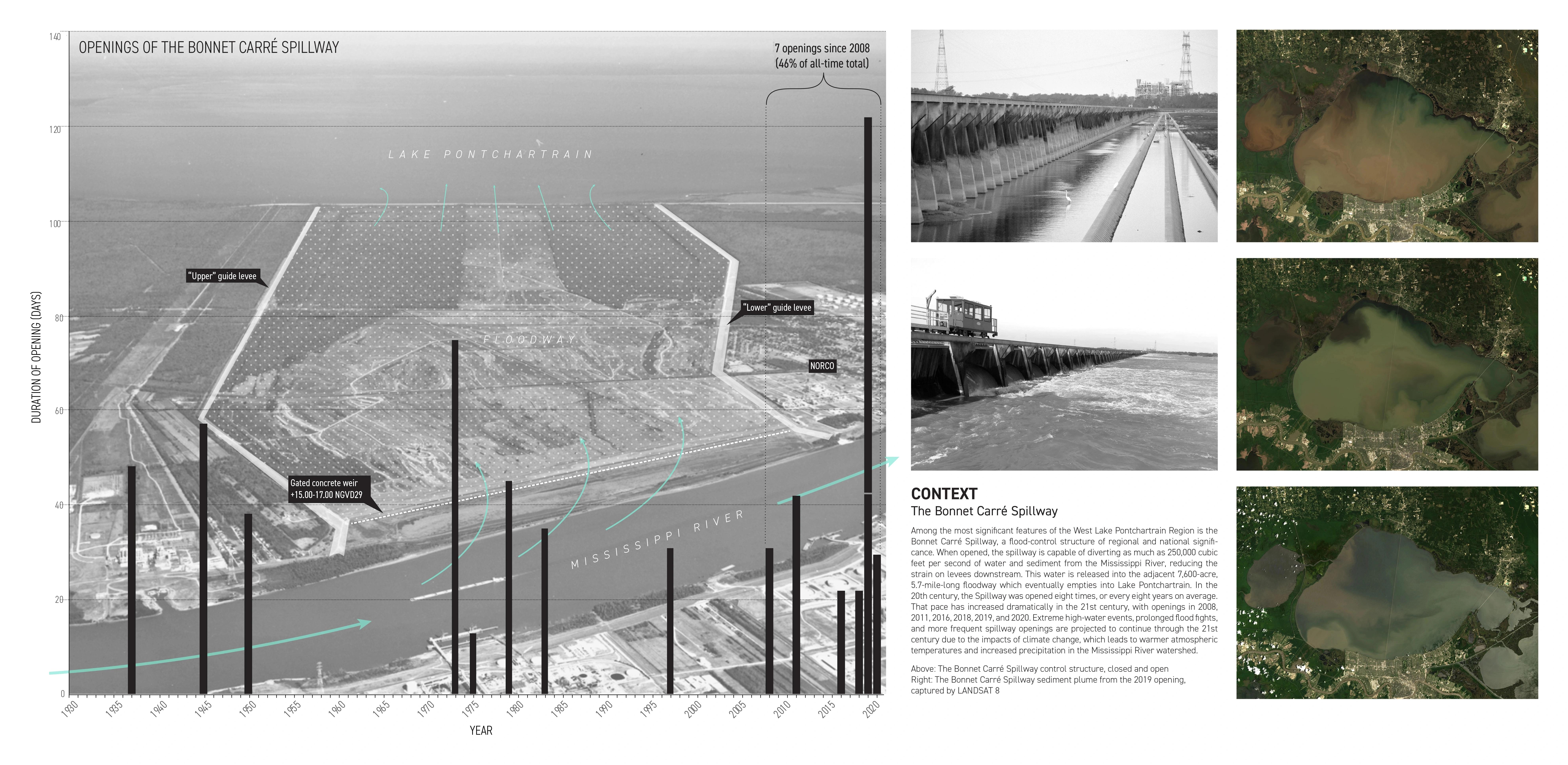
Among the most significant physical features of the West Lake Pontchartrain Region is the Bonnet Carré Spillway. When opened, the spillway is capable of diverting as much as 250,000 cubic feet per second of water and sediment from the Mississippi River, reducing the strain on the new Orleans levees downstream. This water is released into the adjacent 7,600-acre, 5.7-mile-long floodway which eventually empties into Lake Pontchartrain. In the 20th century, the Spillway was opened eight times, or every eight years on average. That pace has increased dramatically in the 21st century, with openings in 2008, 2011, 2016, 2018, 2019, and 2020, leading to algae blooms, salinity flux, and questions about the “new normal” of the spillway’s operation. Frequent spillway openings are projected to continue through the 21st century due to the impacts of climate change, which leads to warmer atmospheric temperatures, increased precipitation in the Mississippi River watershed, extreme high-water events, and prolonged flood fights.
Environmental Challenges and Planned Responses
The West Lake Pontchartrain Region faces a number of long-term environmental challenges due to both natural processes and anthropogenic modifications to the landscape. These include:
• Rapid retreat of the Lake Pontchartrain shoreline, which has moved inland by nearly half a mile since the late 19th century;
• The degradation and collapse of the Maurepas Swamp due to anthropogenic disruptions to the region’s hydrology such as levees and canals;
• Hurricane-driven storm surge flooding from Lake Pontchartrain due to development in low lying areas and sea level rise and exacerbated by the aforementioned shoreline retreat and wetland degradation;
• Increasingly frequent blooms of toxic algae in Lake Pontchartrain due to operations of the Bonnet Carré Spillway and the large volumes of agricultural runoff in the Mississippi River;
• Sea level rise and a warming climate, which will exacerbate all of these challenges.
In response to these challenges, two large-scale infrastructure projects representing nearly $1 billion in investment are currently underway in the region. A $200 million-dollar freshwater diversion project led by the Louisiana Coastal Protection and Restoration authority will restore historic hydrologic connectivity between the Mississippi River and Maurepas Swamp in an attempt to reverse the swamp’s dramatic decline. To the east of this project, the $790 million US Army Corps of Engineers West Shore Lake Pontchartrain Levee will provide hurricane risk-reduction to the population centers of LaPlace, Reserve, and Garyville, as well as Interstate 10 and nearby industrial facilities.
Rising sea levels will likely undermine the efficacy of both of these projects, however, an uncertainty that has been acknowledged by both the US Army Corps and the CPRA. This suggests that currently planned efforts may be less effective than initially envisioned, and that additional strategies and interventions may be warranted in order to safeguard the future of the West Lake Pontchartrain region.
CONCEPT
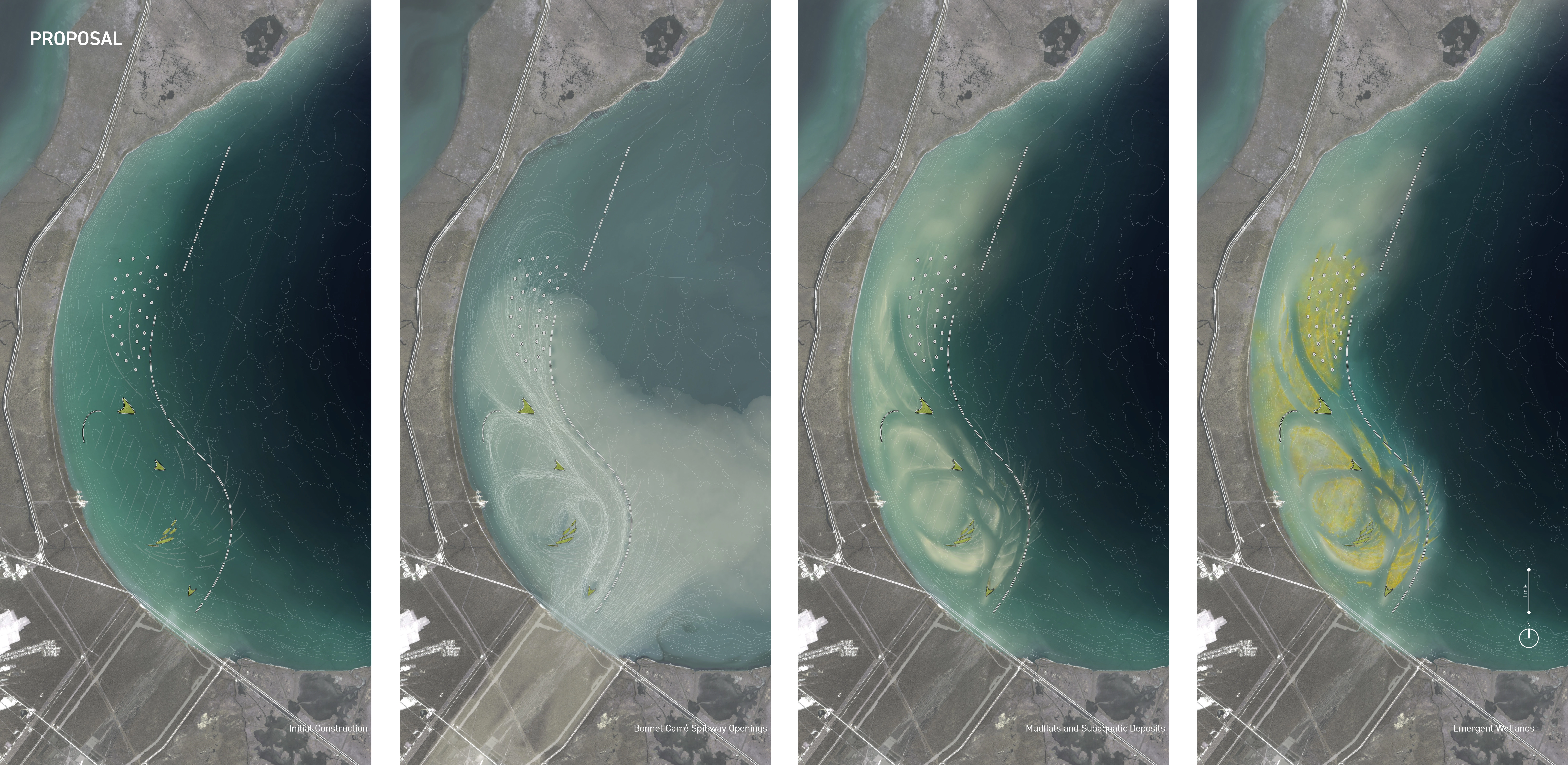
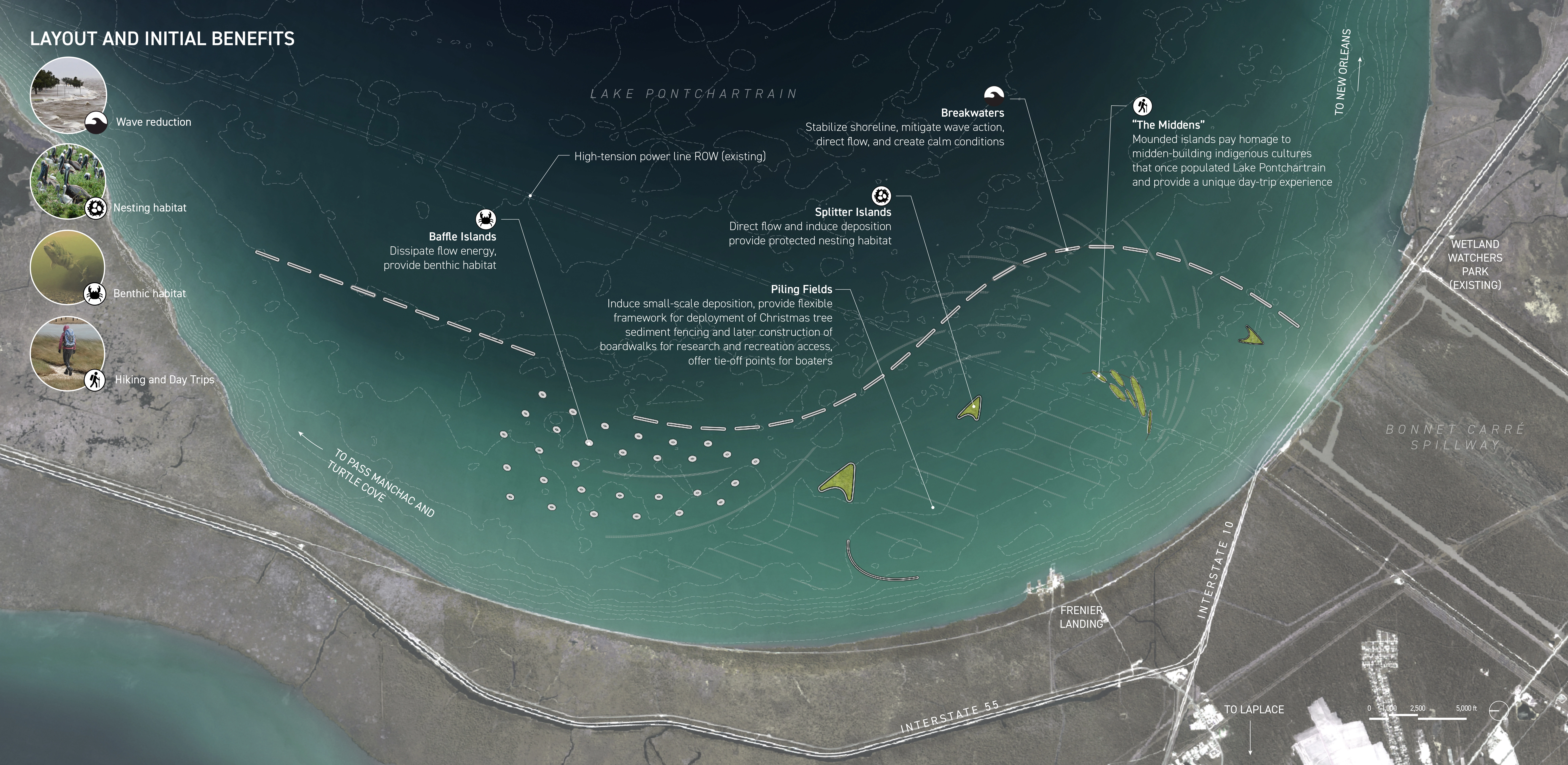
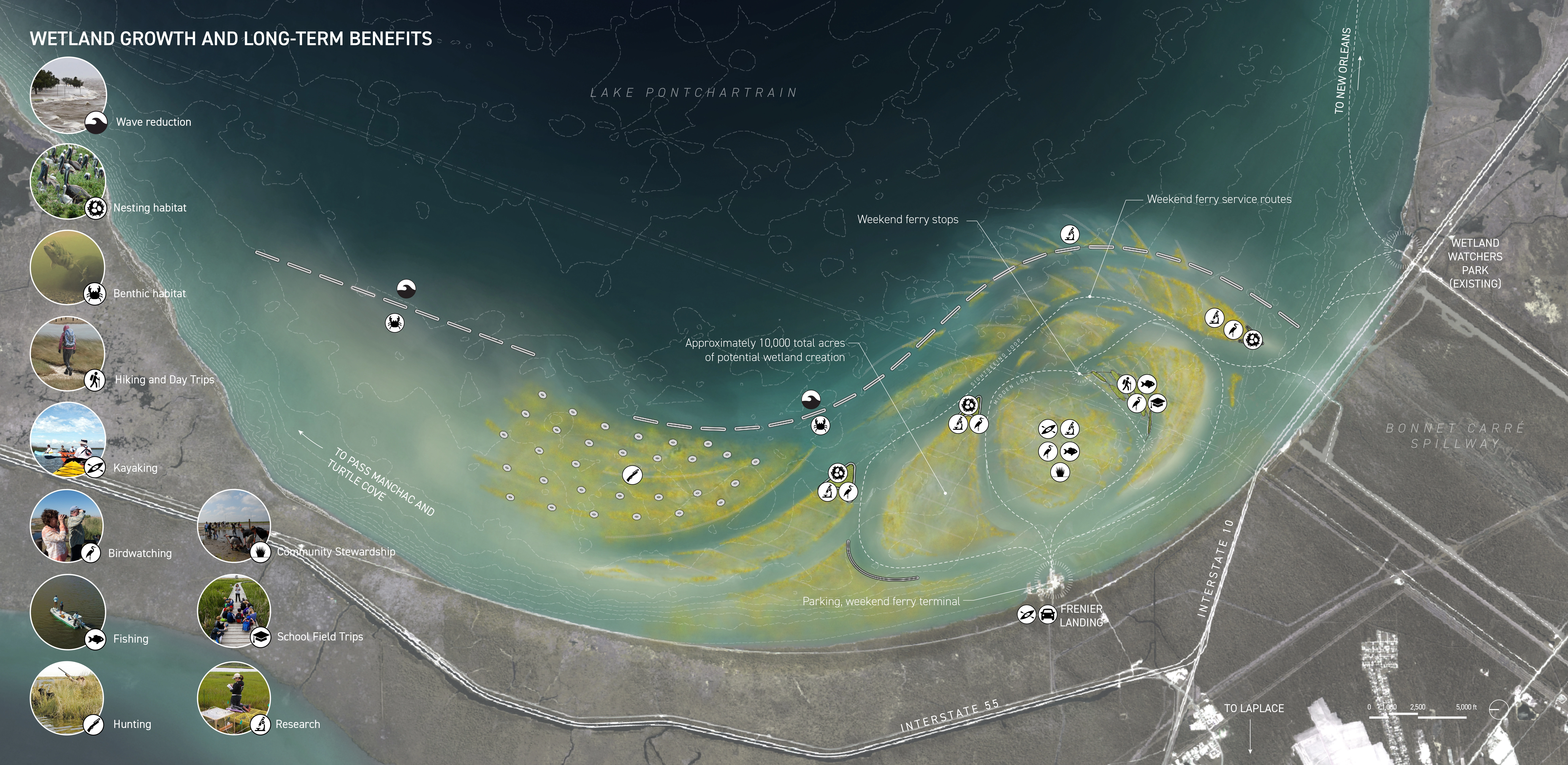
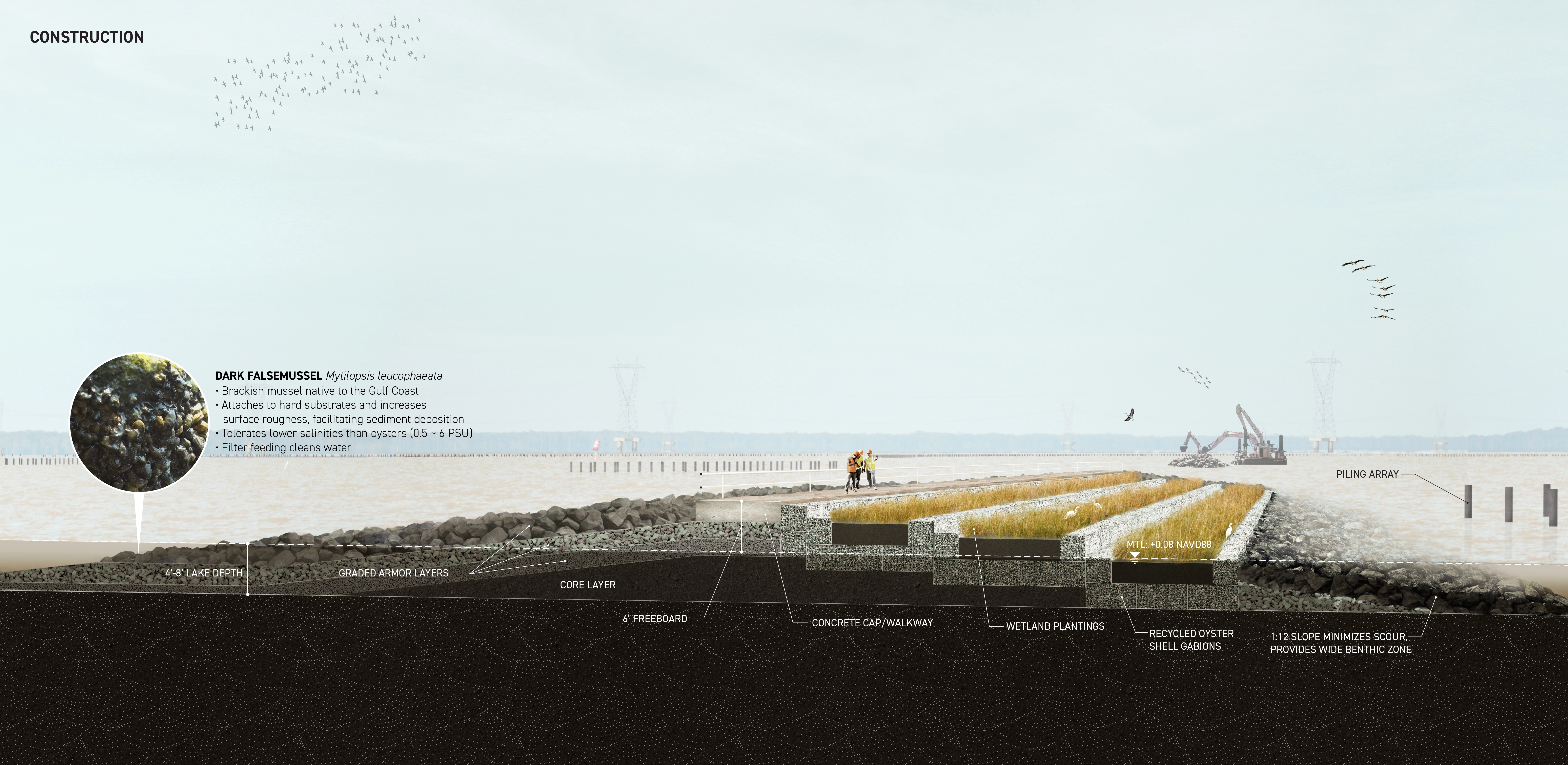
The Siltcatcher envisions a series of offshore breakwater-like structures and associated features in western Lake Pontchartrain positioned to slow water released from the nearby Bonnet Carré Spillway, causing suspended settlement to settle and creating self-building and self-sustaining wetlands capable of keeping pace with future sea level rise. This hybrid grey/green system provides both wetland creation and shoreline protection, serving as a forward line of defense for the communities of the West Lake Pontchartrain region. At the same time, it generates multiple additional overlapping benefits, including habitat creation, water quality mitigation, and recreational, educational, and community building opportunities.
PROCESS
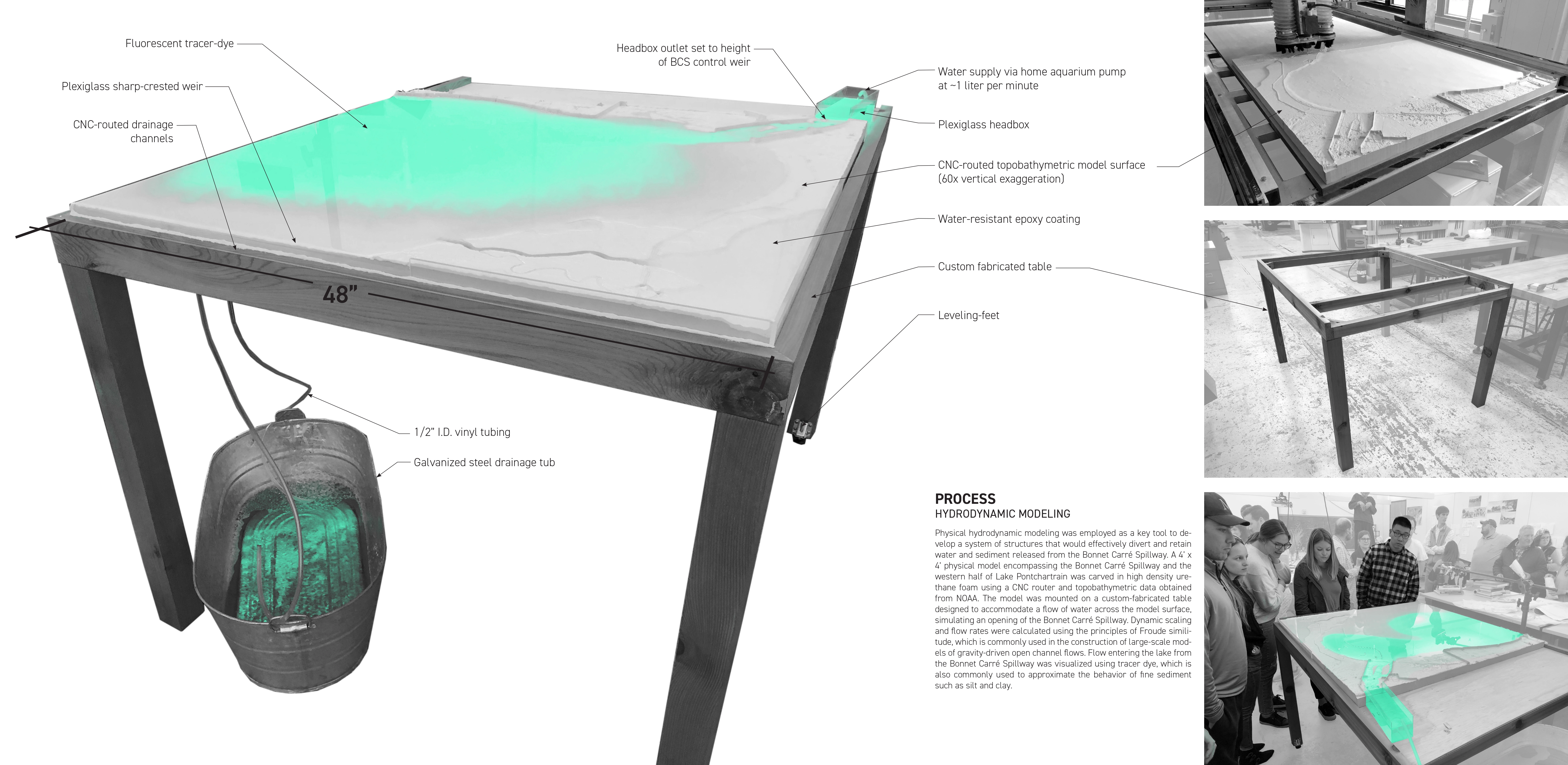
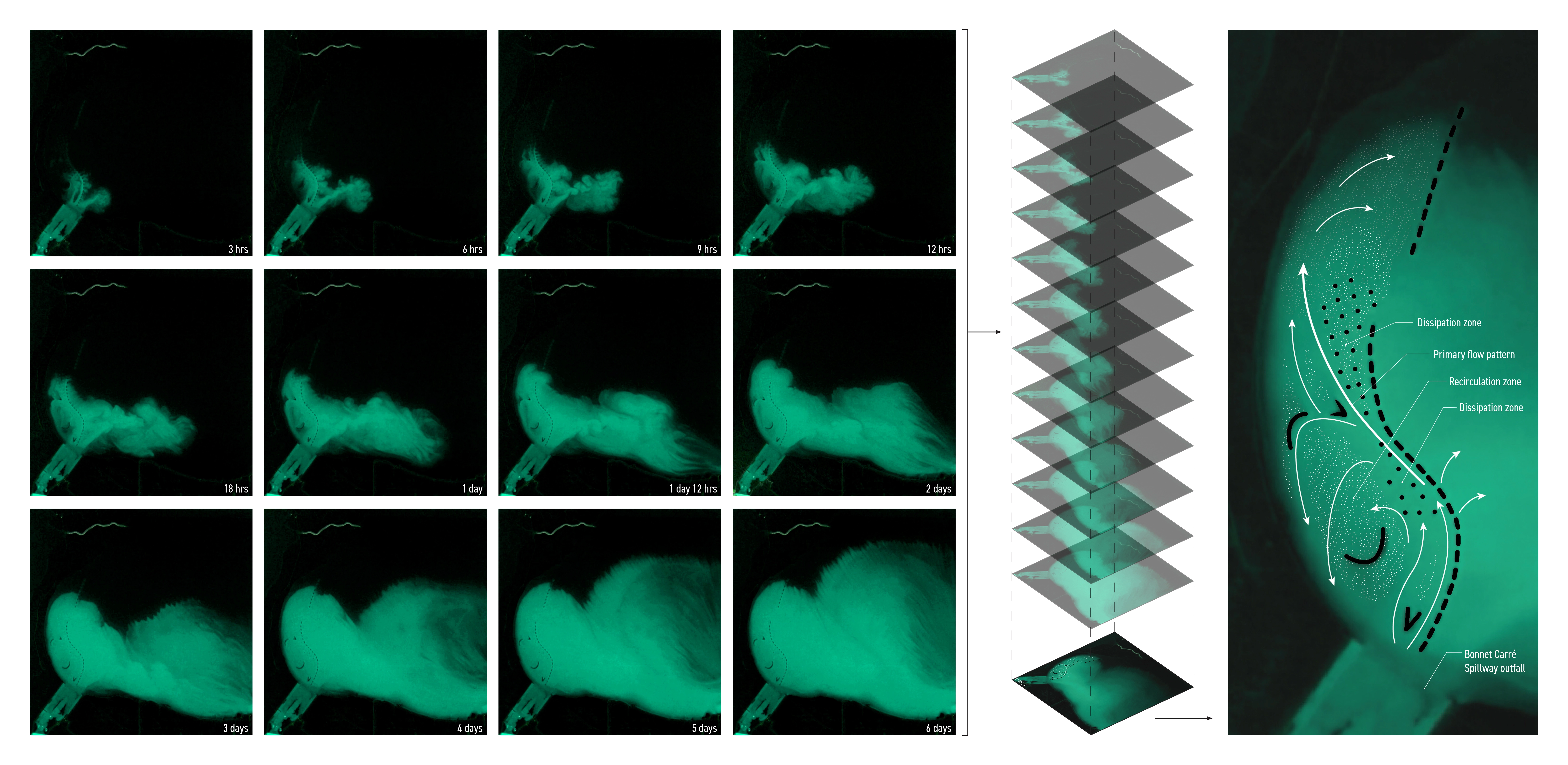
Physical hydrodynamic modeling was employed as a key tool to develop a system of structures that would effectively divert and retain water and sediment released from the Bonnet Carré Spillway. A 4’ x 4’ physical model encompassing the spillway and the western half of Lake Pontchartrain was carved in high density urethane foam using a CNC router and topobathymetric data obtained from NOAA. The model was mounted on a custom-fabricated table designed to accommodate a flow of water across the model surface, simulating an opening of the Bonnet Carré Spillway. Dynamic scaling and flow rates were calculated using the principles of Froude similitude, which is commonly used in the construction of large-scale models of gravity-driven open channel flows. Flow entering the lake from the Bonnet Carré Spillway was visualized using tracer dye.
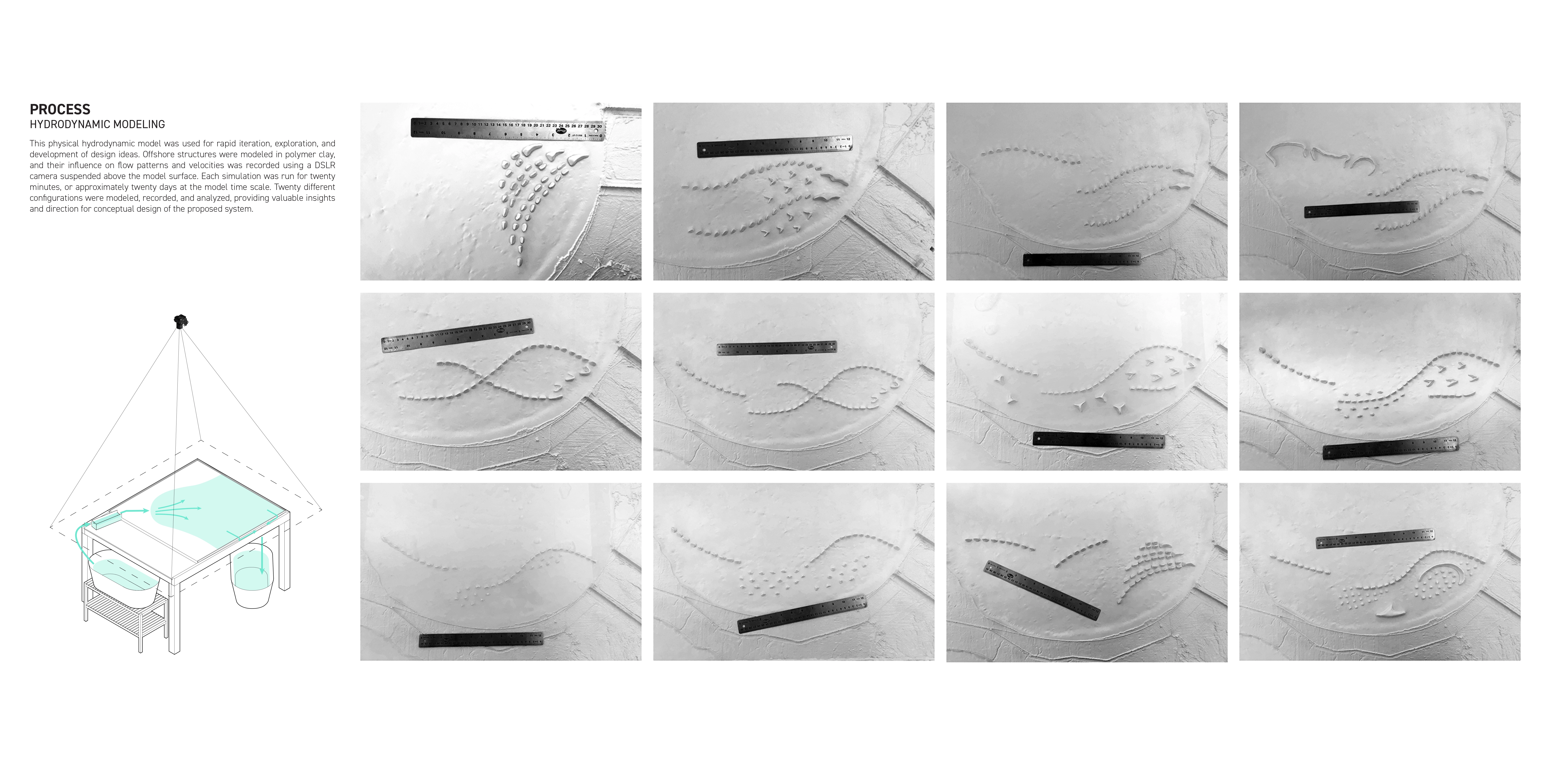
This physical hydrodynamic model was used for rapid iteration, exploration, and development of design ideas. Offshore structures were modeled in polymer clay, and their influence on flow patterns and velocities was recorded using a DSLR camera suspended above the model surface. Each simulation was run for twenty minutes, or approximately twenty days at the model time scale. Twenty different configurations were modeled, recorded, and analyzed, providing valuable insights and direction for conceptual design of the proposed system.
PROPOSAL
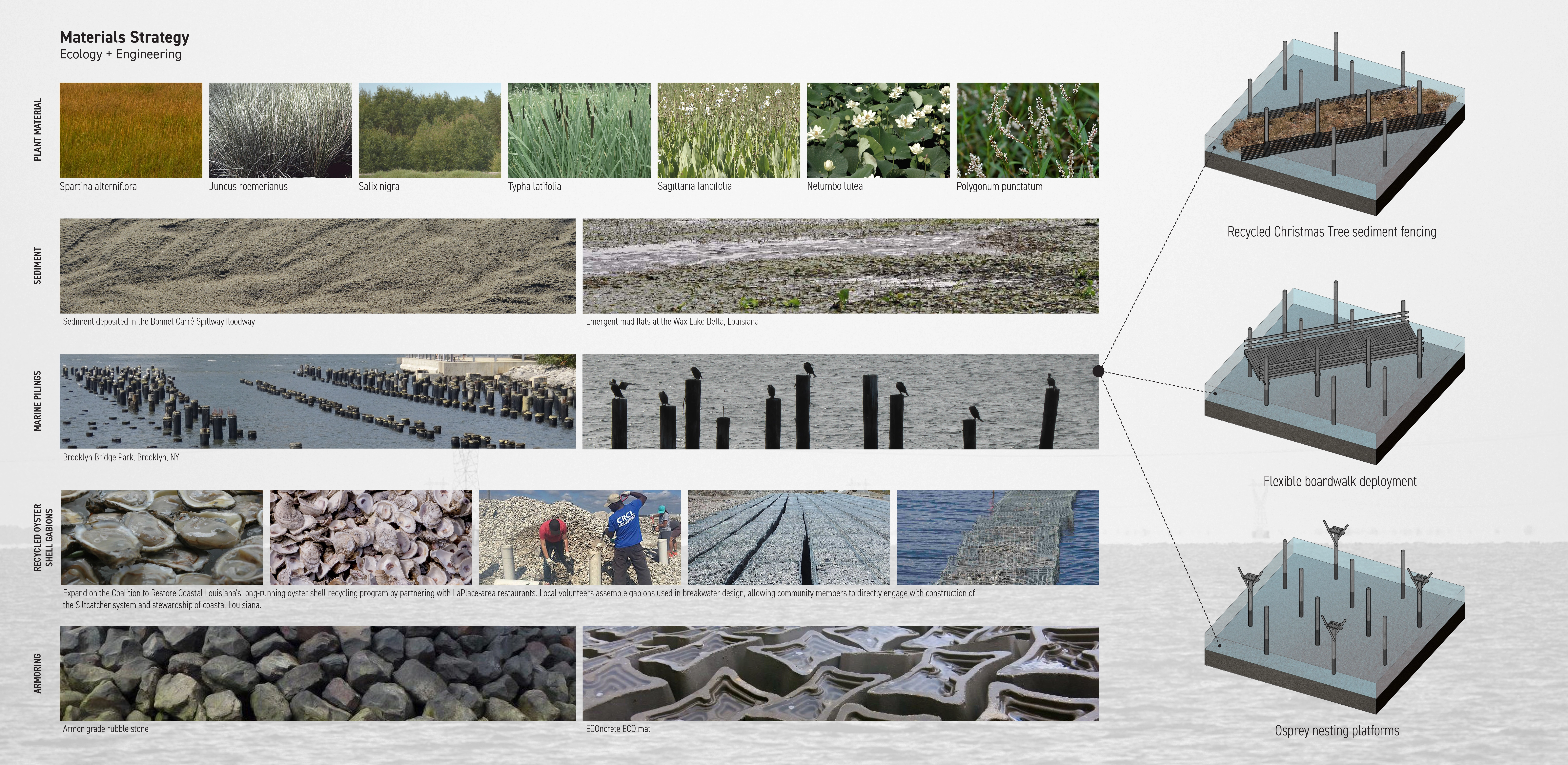
The proposed design represents a multi-layered, multi-functional approach to coastal infrastructure and living shoreline deployment. A forward line of ecologically designed breakwaters both directs flows exiting the spillway and creates a calm, protected area for sediment settling and deposition. A series of dredge-fill “splitter” islands mimic the geometry of islands in active prograding deltas, jump-starting depositional processes while also providing protected bird-nesting habitat. At the center of the proposed system, a group of elongated, elevated landforms inspired by the midden-building indigenous peoples that populated the region prior to European colonization rise above the lake’s surface, providing a destination for day-trips, fishing, and hiking, and providing unique views of the lake and the surrounding areas. Arrays of marine pilings radiate out from these centrally located islands, providing an armature for the flexible deployment of sediment-collecting recycled Christmas tree sediment fences, boardwalks, and osprey nesting platforms. In addition to protecting the Lake Pontchartrain shoreline and the communities of the West Lake Pontchartrain region, the proposal provides a broad range of recreational and educational opportunities for local residents, including fishing, hunting, kayaking, birdwatching, school field trips, and research.
This project represents a novel approach to the design and conceptualization of coastal infrastructure by marrying iterative, architectural design methodologies with qualitative hydrodynamic models commonly used in civil and coastal engineering. Such an approach allows dynamic and temporal processes to be transformed from risks to be managed to sources of design inspiration. The designer, rather than sculptor of a static object, becomes the conductor of an unruly orchestra, organizing and directing the flows, fluxes, and processes responsible for the creation of deltaic landscapes while acknowledging their autonomy and agency. In a time and place where prevailing narratives are centered on erosion and loss, the Siltcatcher would become a place where the life-giving poetry of deltaic land creation could be witnessed, enjoyed, and celebrated. -
- Kevin Benham - Assistant Professor, LSU Robert Reich School of Landscape Architecture
- Clint Willson - Mike N. Dooley, P.E. Professor, LSU Department of Civil and Environmental Engineering
- Robyn Reed - Assistant Professor, LSU Robert Reich School of Landscape Architecture
-
- Spartina alterniflora (Smooth cordgrass)
- Juncus roemerianus (Black Needlerush)
- Salix nigra (Black willow)
- Typha latifolia (Cattail)
- Sagittaria lancifolia (Lanceleaf arrowhead)
- Nelumbo lutea (American lotus)
- Polygonum punctatum (Dotted smartweed)
Advertisement
Related Awards

Award of Excellence, General Design
A Floating Forest: Fish Tail Park in Nanchang City
In Nanchang, within the Yangtze River floodplain, we revitalized a heavily degraded 126-acre landscape into a floating forest that manages stormwater, restores habitats, and provides diverse recreational spaces—all within a limited budget and a short timeline. This innovative urban nature model strengthens the district’s identity and spurs surrounding development. Fish Tail Park offers a scalable solution for flood-prone regions, seamlessly integrating flood resilience, ecological restoration