.webp?language=en-US)
'Tenacity' - Integrating Sea Level Rise and Urban Growth Prediction Modelling in Design Scenarios in Tampa, Fl.
Karishma Joshi, Student ASLA; Jiali Liu

Tampa, Florida is expected to grow considerably over the next decades, yet is one of the most vulnerable U.S. cities for flooding. Simply continuing on the present course, or even in line with current planned growth, will do little to mitigate flood risk, but informed development that incorporates resilient tactics will ensure long-term resilience in uncertain climate scenarios. This study analyzes three possible development strategies, and recommends one that could mitigate the impact of sea-level rise.
Awards Jury
-
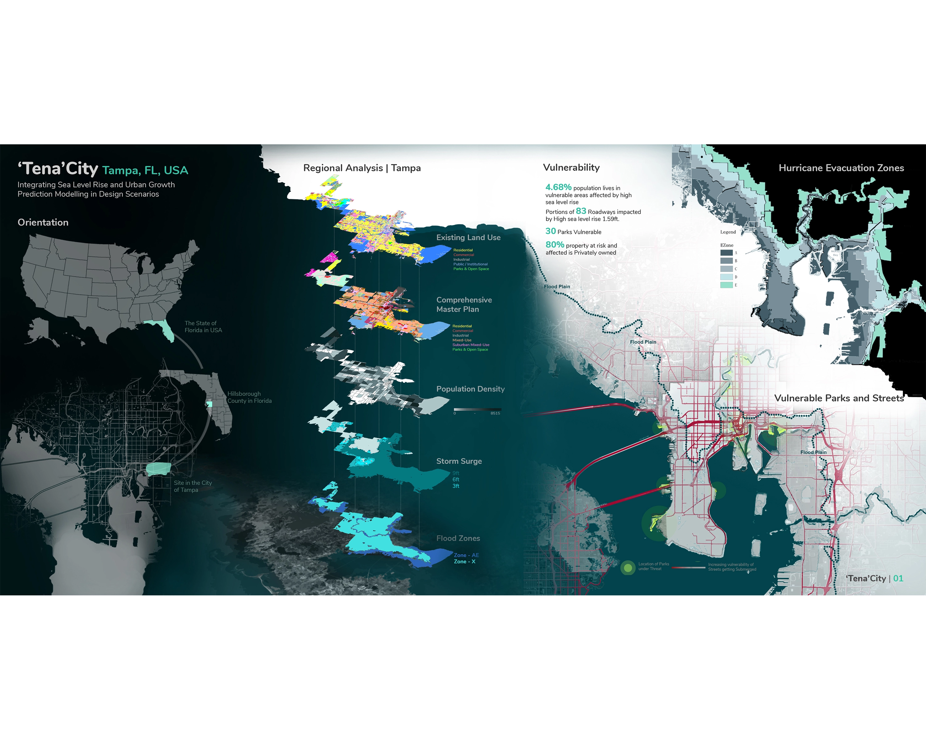
Urban expansion can worsen climate change conditions and enlarge hazard zones. Sea level rise due to climate change makes coastal populations more susceptible to flood risks. The use of land change prediction modelling to inform scenario-based planning has been helpful to increase capabilities when dealing with uncertainties in urbanization such as urban growth and flood risk, when compared to singular comprehensive plans. “Tenacity” uses the Land Transformation model to predict three different urban growth scenarios for Tampa, FL to determine how effective the current comprehensive plan is in adapting urban growth to decreasing flood risk and pollutant load. To achieve this, the project develops master plans according to each scenario and assesses their probable impact using the Long-Term Hydrologic Impact Analysis Low Impact Development Spreadsheet as a performance model. Findings of an in-depth analysis show that the current future land use plan for Tampa, while it appears to be better than current patterns of development, has higher flood exposure, storm-water run-off, and pollutant discharge than current conditions and should follow more resilient approaches to growth.
-
Introduction
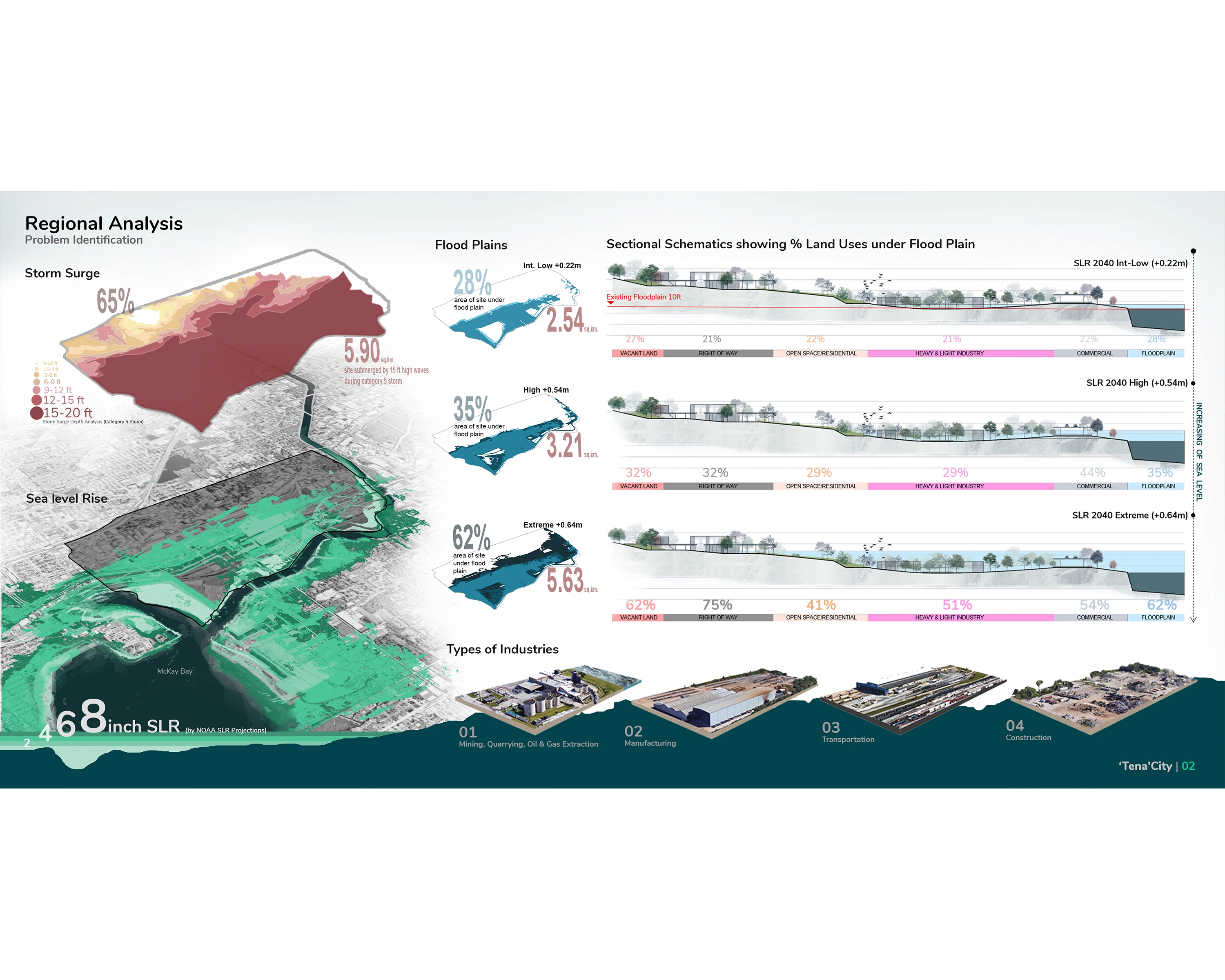
Tampa, FL is ranked in the top five in the most vulnerable U.S. cities to flooding and is expected to grow by over 100,000 people by 2040. Sea level rise also makes coastal populations more susceptible to flood risks. When open space land uses are converted to urban land uses, flood risk can increase. The capability to accurately predict both future flood plain changes and future urban growth allows for the capacity to better protect coastal communities from the effects of future climate change and helps support flood risk mitigation. With Tenacity, we integrate sea level rise and urban growth prediction modelling in design scenarios to produce sustainable design solutions to be implemented in urban design master plans for a heavily industrialized and marginalized neighborhood.
Goals and Objectives
The objective of this project was to understand how effective the current comprehensive plan is in adapting urban growth to decreasing flood risk and pollutant load and offer comparisons and solutions to offset any of its shortcomings. To do this, we propose a combination of new development and regeneration strategies and run resilience analytics and landscape performance models to analyze the impacts of each development scenario. Tenacity both develops and operates measures to evaluate the performance of the built environment, using baseline data to compare new urban growth schemes against to determine design benefits.
Problem Statement
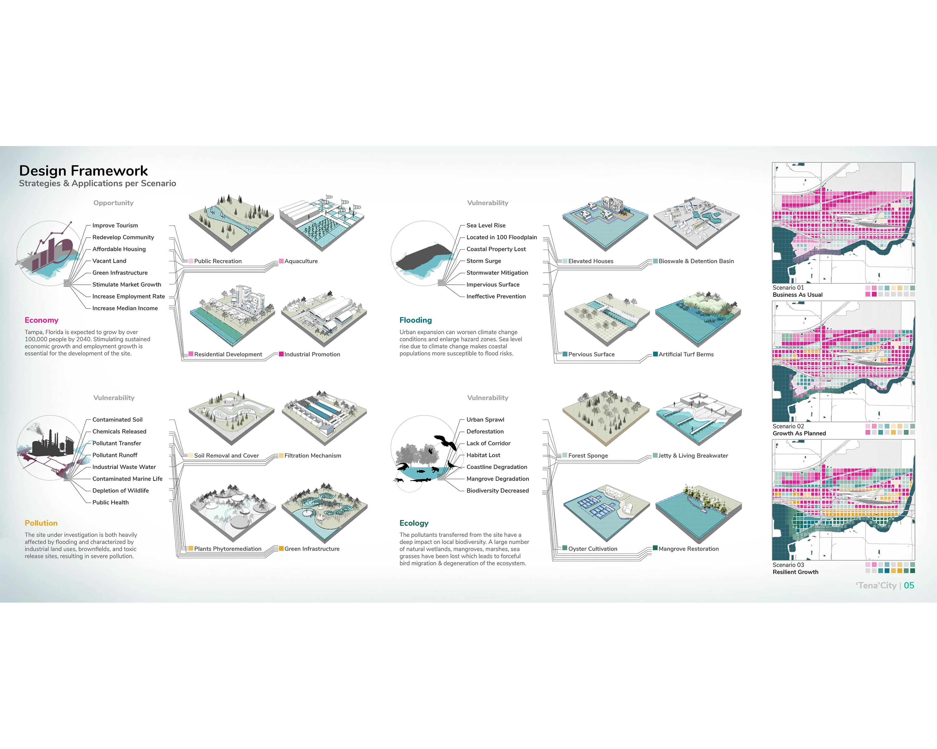
The site is in the south eastern part of Tampa, along the Palm river, where it meets the McKay Bay which feeds into Tampa Bay. It is both heavily affected by flooding and characterized by industrial land uses, brown fields, and toxic release sites, resulting in severe pollution and related effects from runoff containing industrial by-products. This creates a direct impact on the aquatic life, local biodiversity, and indirectly affects human health due to polluted groundwater and air. The existing growth patterns are negligent towards these environmental problems and the site is in need of a design which properly applies both and structural and nonstructural mechanisms to build a resilient neighborhood. Tenacity builds on to these needs, using advanced spatial forecasting models and innovative design solutions based on growth predictions and design scenarios.
Methodology
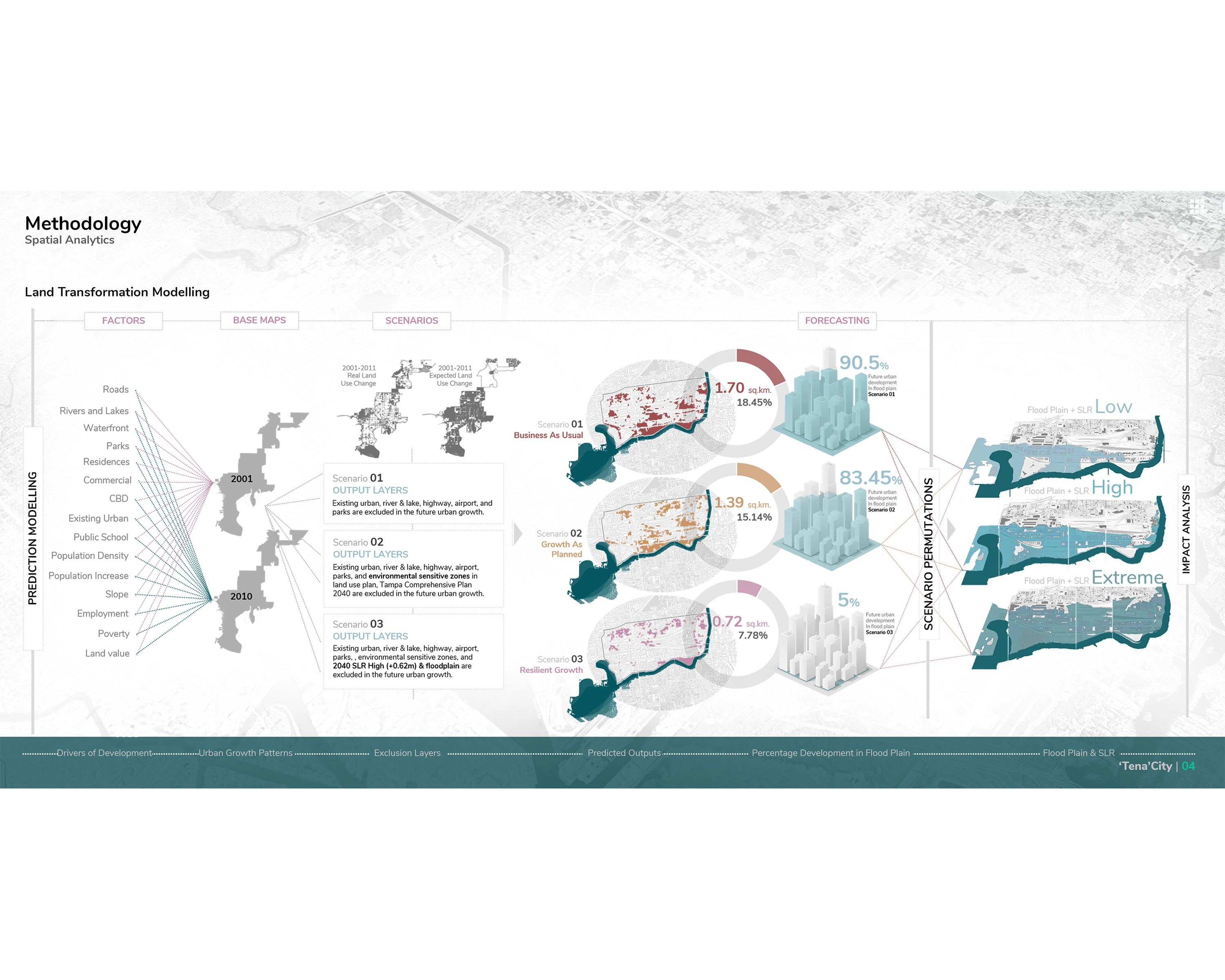
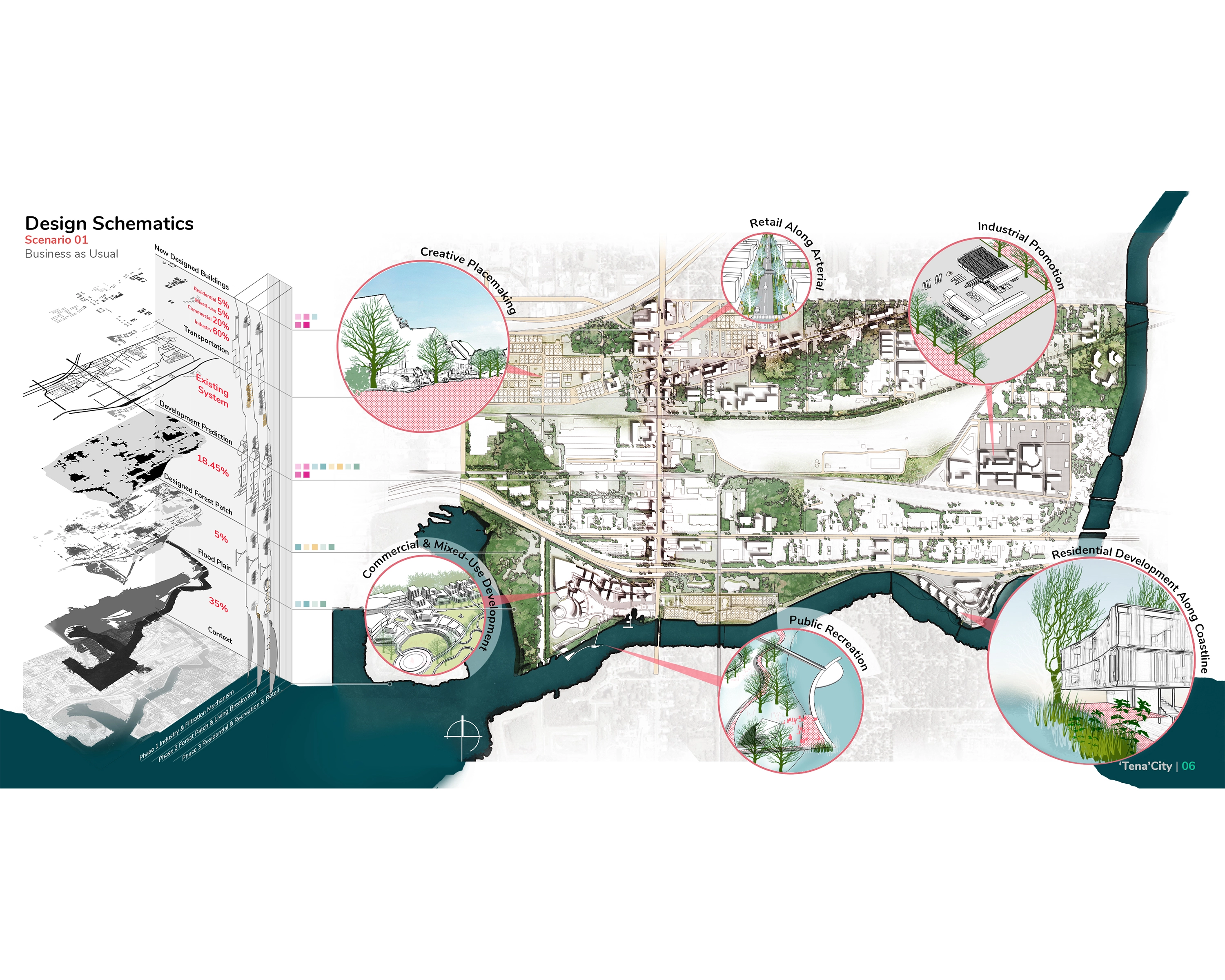
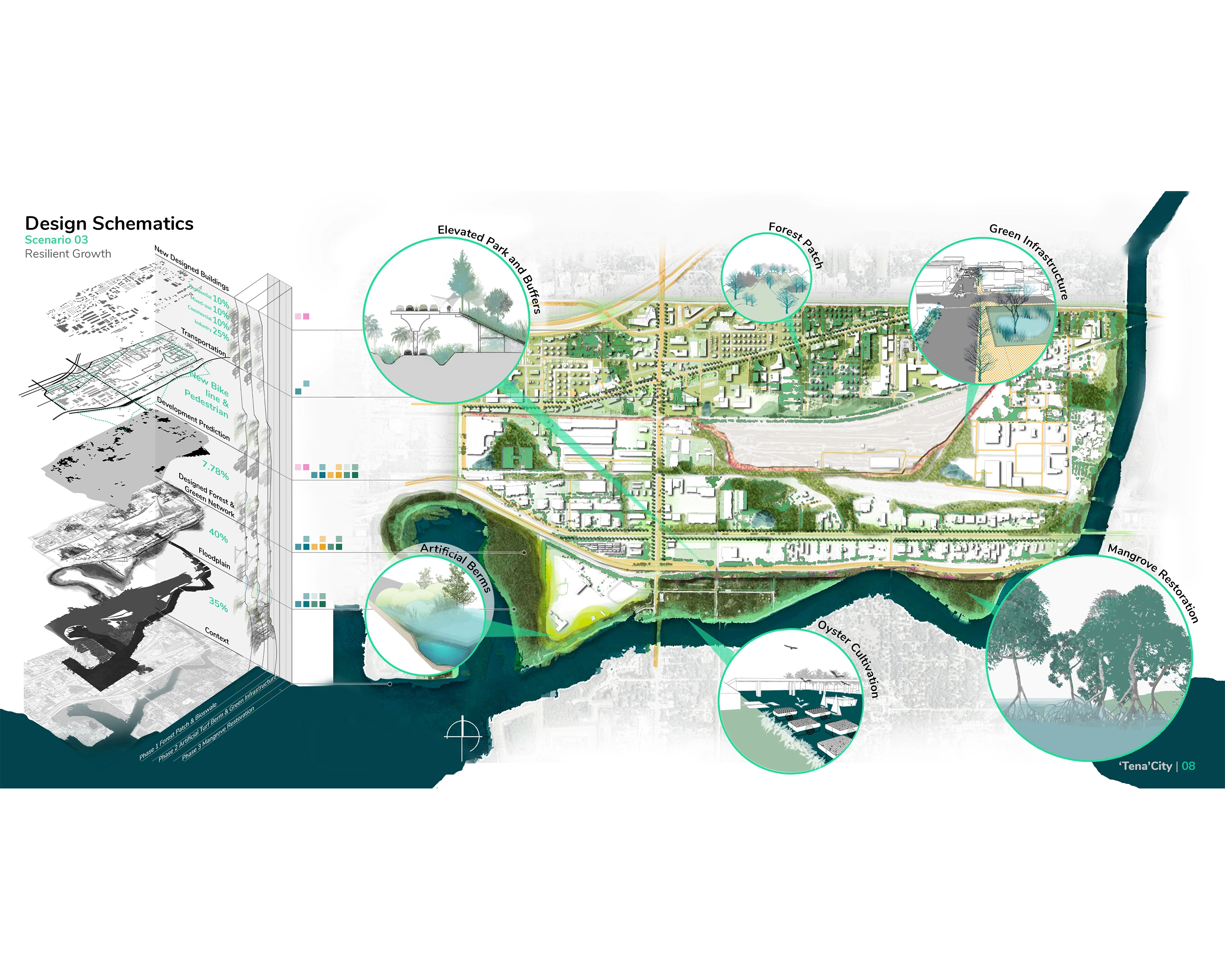
Tenacity uses a series of tools on multi-scalar spatial datasets to increase resiliency. The Land Transformation Model (LTM) is a GIS-based neural network, used to predict land uses, examining relationships between spatial driving factors and land use changes. The LTM uses machine learning to calculate complex patterns through an artificial neural network. In this project, it is used to predict potential future urban growth of Tampa according to three different scenarios: 1) Business as usual – predicted urban growth based on current growth patterns; 2) Growth as planned – predicted urban growth based on the current land use plan; and 3) Resilient growth – predicted urban growth based on all future development occurring outside of the floodplain.
Enhancing resilience in areas vulnerable to flooding is most effective with participation from the local community. The engagement process used to develop the master plan scenarios relied on feedback loops that support resilient design and planning. Research and design on these issues in this neighborhood were undertaken using a participatory approach in cooperation with local senior planners, public health researchers, machine learning flood modeling experts, and community contaminant sampling specialists.
Prediction Modelling
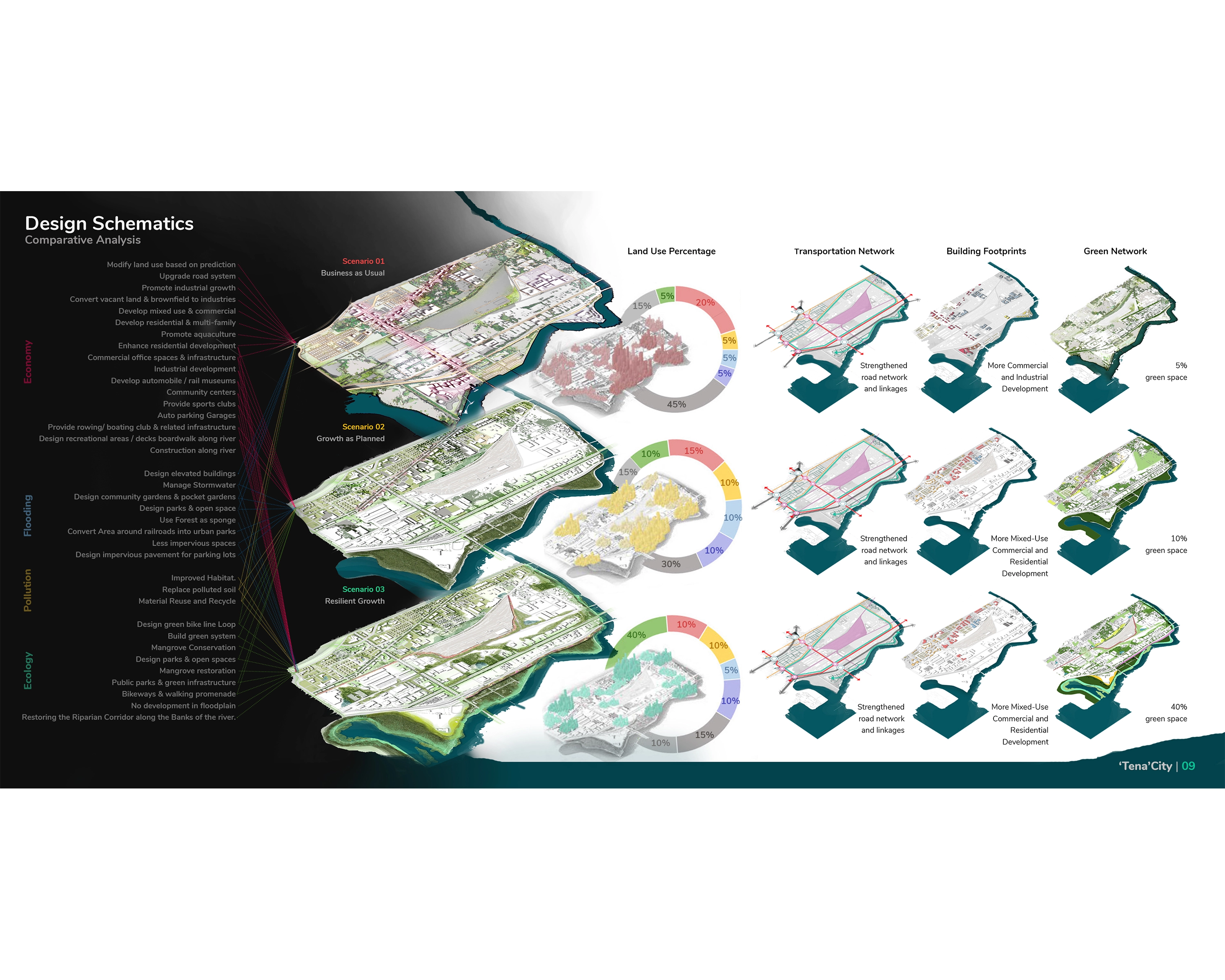
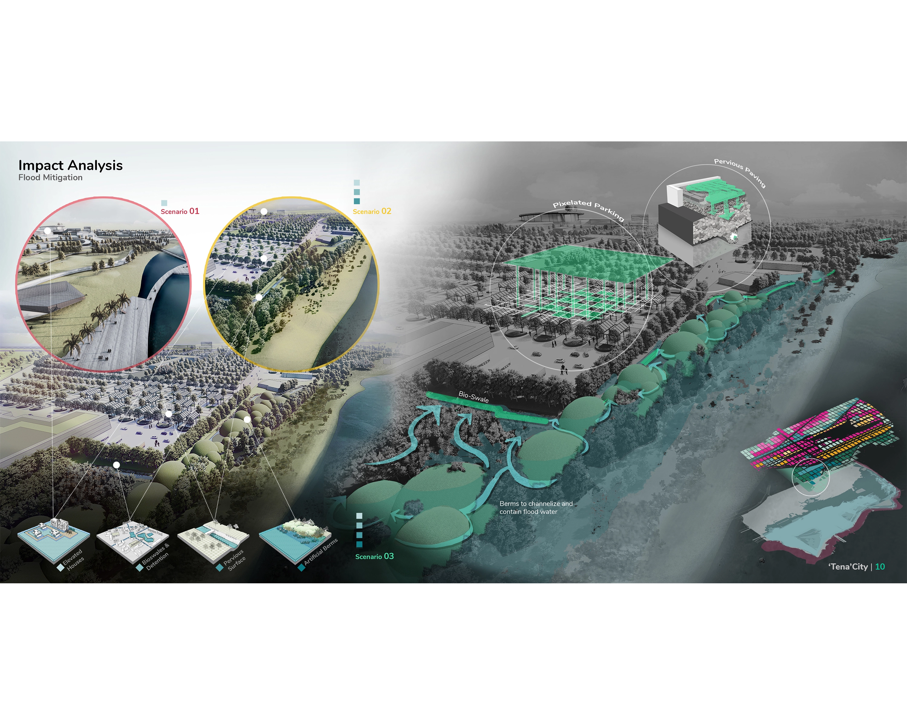
Urban flood exposure is calculated by overlapping existing urban and projected future urban scenarios with the delineated future flood risk zones. Following the previous land change ratio, there was a change of 8,917 pixels between 2001 and 2011, projecting a population increase of 32,600 people. The future urban growth scenarios project a change of 48,395 pixels corresponding to a 176,928 population change between 2001 and 2040. The predicted development pixel amounts are the same for all scenarios, but the locations of the pixels are different based on different exclusionary layers in each scenario. Business as usual (scenario 1) excludes existing urban, rivers and lakes, highways, airports, and parks from future development areas; Growth as Planned (scenario 2) also excludes environmentally sensitive areas from the future land use (according to the comprehensive plan’s policy); and Resilient Growth (scenario 3) also excludes development within future flood risk zones (2040 SLR High and 100-year floodplain).
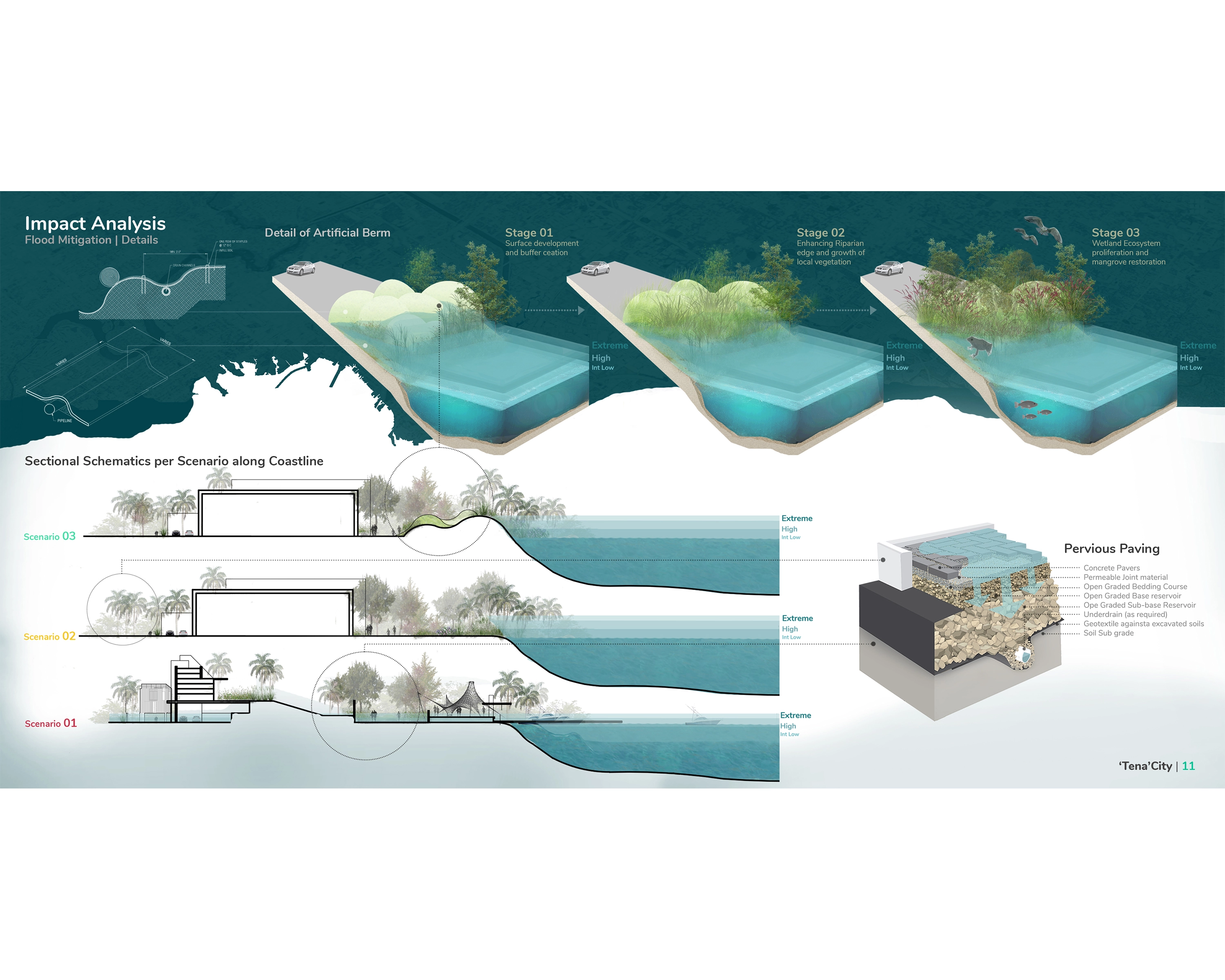
Design Schematics and Master Plan Outcomes
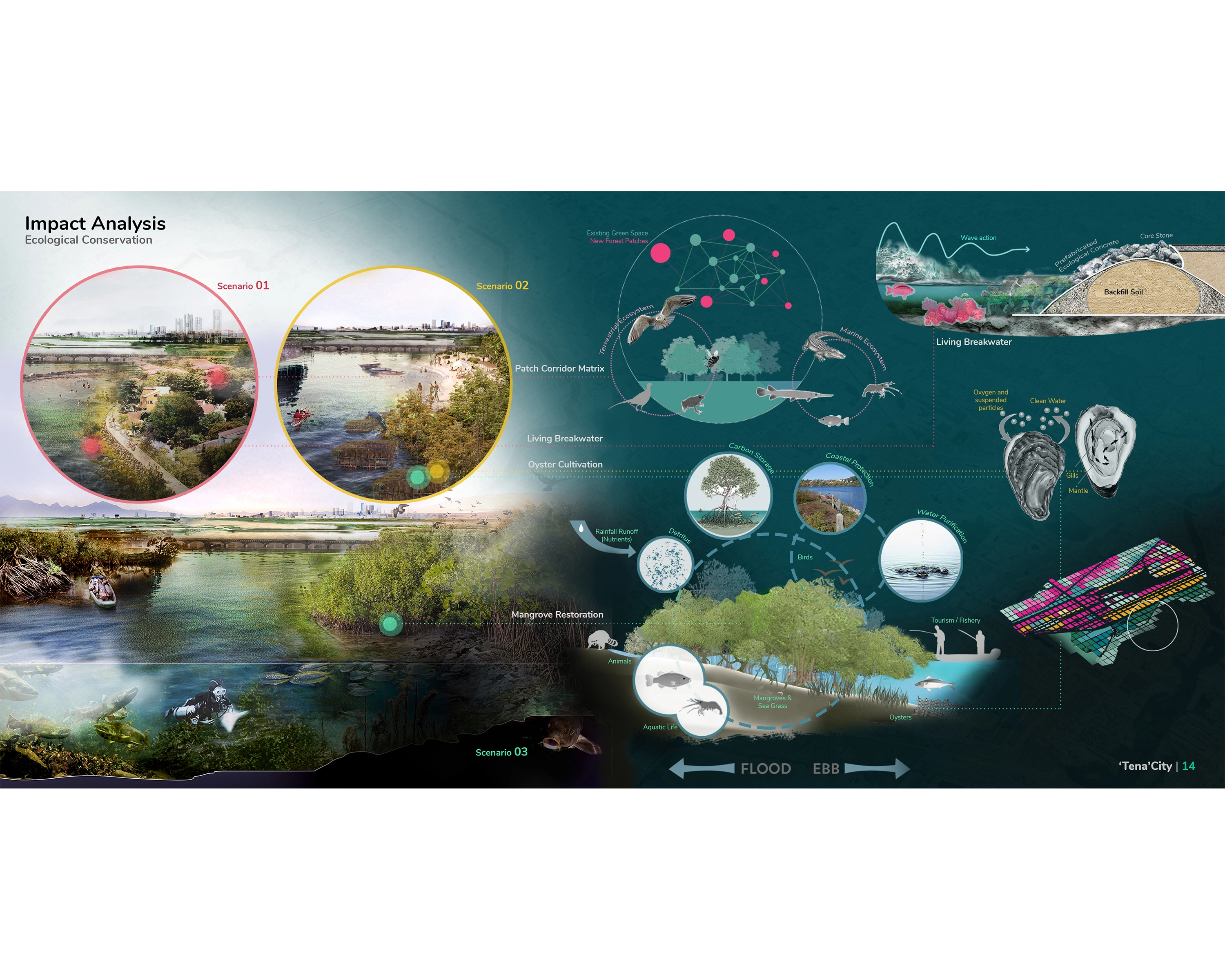
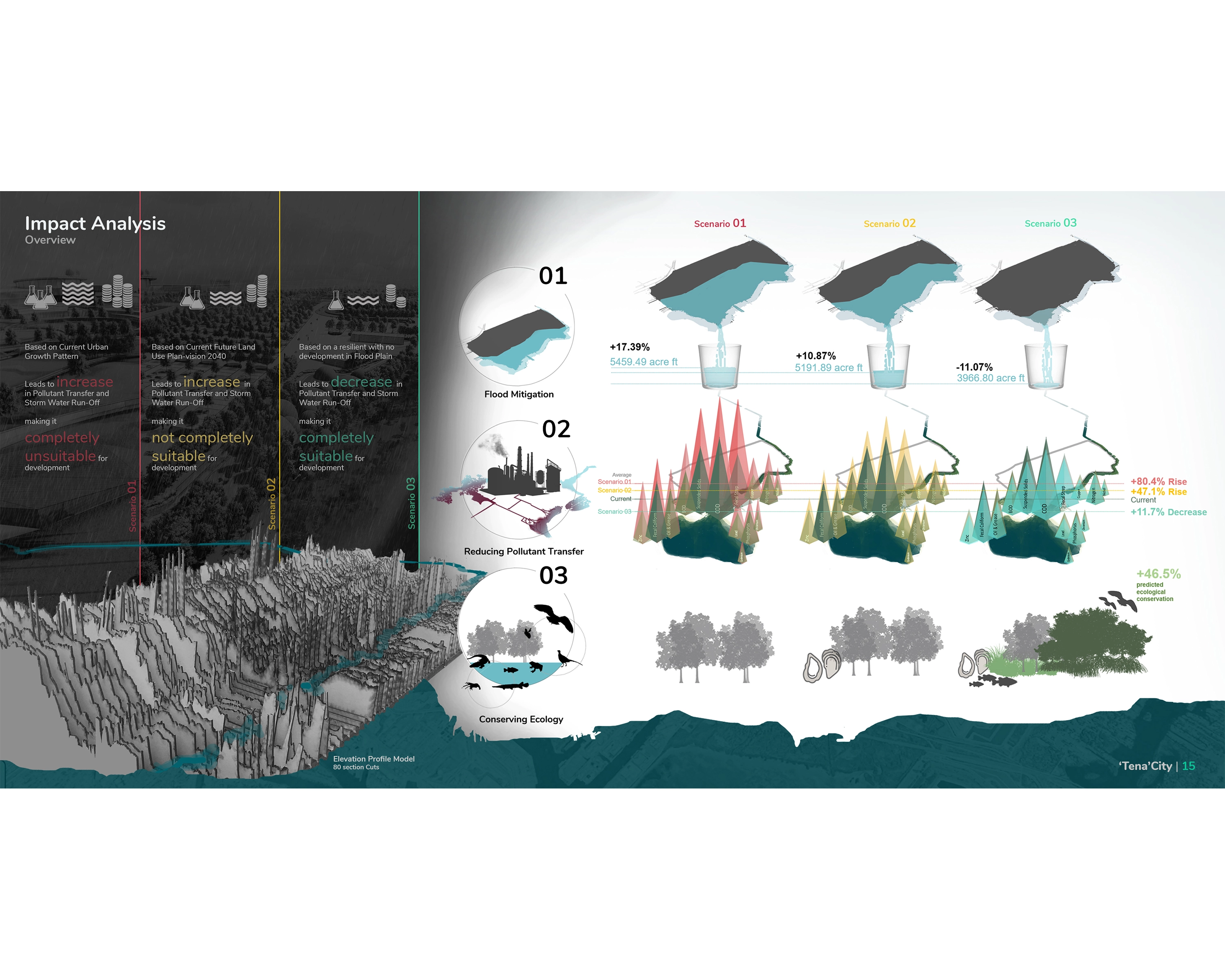
The designs used the relative locations and amounts of the LTM prediction outputs to inform development locations and land use arrangement. The transportation hierarchy remained the same across all design sites but densities and land use arrangements altered since the location of new development was restricted in certain areas in the growth as planned and resilient growth scenarios. Within the site, nearly 90% of the new growth in scenario 1 would be in the floodplain, 83% in scenario 2 and only 5% in scenario 03. Each master plan outcome builds on a framework of design strategies categorized under four major categories of promoting economy, reducing pollutant transfer, flood mitigation and conserving ecology.
Design Impact and Benefit
The performance model outputs, based on the L-THIA performance spreadsheet, for the current conditions suggest that the business as usual scenario increases impervious surfaces, decreases green infrastructure area, increases area within high flood risk, and increases public exposure to contaminants/pollutants in surface runoff, compared to the other two scenarios. While growth as planned reduced pollutants compared to business as usual, both scenarios increase pollutant load in runoff compared to the current land use arrangement. The resilient growth scenario appears to be the most optimal approach.
Using an adaptive approach for implementation, there are four key benefits for flood prone communities and practitioners when using the aforementioned scenario-based process. First, the process allows city officials to develop new knowledge about flood related spatial conditions. Local knowledge related to current issues and desired land uses can be incorporated, while local planners simultaneously gain the ability to spatially distinguish where effective policy to reduce flood risk is already in place and which areas could be in the 100-year flood plain in the future. Second, current and new knowledge can be used as a basis for design and planning-based decision making. Typically, economic and aesthetic concerns are the primary drivers of design-based decision making. However, the design process presented here allows for better placement of new development as well as the strategic allocation of necessary infrastructure to help protect it. Third, according to the design impact models, the sustainable growth plan creates a more resilient community compared to conventional development practices. The reduction of the area of the 100-year flood plain due to structural and non-structural placement of flood attenuation mechanisms as well as the pollutant load reduction due to increased green infrastructure show that resiliency is increased. Finally, the process not only allows for increases in current resiliency, but can also better prepare neighborhoods for the future impacts of sea level rise. Most modeling and projections for climate change occur at the regional scale or larger. As demonstrated in this project, community scaled conditions can be used to proactively inform community layout, resulting in longer-term stability, reductions to future flood risks, and decreased contamination.
Conclusion
Tenacity examines future urbanization using prediction modelling coupled with scenario planning to advance conditions for uncertain future climate change. The project sets an example to demonstrate a scenario matrix using urban growth and flood risk with sea level rise scenarios and impact analysis with scenario evaluation. Analytical findings show that the current future land use plan for Tampa may not be the best approach for dealing with climate change, in terms of urban flood exposure, storm-water runoff increase, and pollutant discharge and can be made better suited with the application of innovative design solutions and urban design and planning guidelines incorporated in the resilient growth approach. -
- Dr. Dongying Li - Committee Member / Advisor
- James Tate - Committee Member / Advisor
-
- Piper marginatum
- Jatropha curcas
- Chrysopogon zizanioides
- Pennisetum purpureum
Advertisement
Related Awards
Honor Award, Analysis & Planning
A Cultural Approach: The Fort Peck Tribes Hazard Mitigation Plan
In collaboration with the Fort Peck Assiniboine and Sioux Tribes, EPA, and FEMA, the Fort Peck Tribes Hazard Mitigation Plan (HMP) adopts a culturally responsive approach to hazard mitigation planning that features connection to place.