Storm + Sand + Sea + Strand -- Barrier Island Resiliency Planning for Galveston Island State Park
Award of Excellence
Analysis and Planning
Galveston, TX, USA | Studio Outside | Client: Texas Parks & Wildlife Department
Cover
Galveston Island State Park (GISP) claims 2,000 acres on the barrier island an hour south of Houston. This is the only location on the island where the natural bay-to-beach cross section of island habitat is accessible.
Photo Credit: Google Earth Aerial
images@asla.org.
09.10.2008
The island habitat is rich in diversity and home to many threatened and endangered species. Extremely flat, the slightest rise reveals expansive views of the tapestry of water, marsh, and prairie.
Photo Credit: Studio Outside
images@asla.org.
Storm History
Although tropical cyclones are frequent, development on barrier islands has intensified and continues to result in escalating losses, even in lower category storm events.
Photo Credit: Google Earth Aerial
images@asla.org.
09.14.2008
Infrastructural damages from Ike were staggering, and previously compromised natural systems were further impacted. Over 75 linear feet of beach and two-thirds of the park’s campsites were reclaimed by the Gulf during the storm.
Photo Credit: TPWD
images@asla.org.
50-YR Land Loss
A primary challenge is to identify and plan for a site in constant transition – predictive models forecast impacts and reveal a dramatically different site in 50 years.
Photo Credit: Google Earth Aerial
images@asla.org.
SHIFTING ECOLOGY
Six inches in elevation can define a very different habitat. As water and plants migrate over time, so does wildlife. Structures must accommodate both present and future conditions to preserve investment and ensure habitat viability for future generations.
Photo Credit: N/A
images@asla.org.
PUBLIC OUTREACH
The park is a meaningful setting for the memories of many Texas families. Approximately 9,000 Galvestonians were displaced by Ike, and an extensive outreach campaign sought to connect those stories with input from current and potential visitors.
Photo Credit: N/A
images@asla.org.
PUBLIC PROGRAM PRIORITIES
Outreach and jurisdictional collaboration revealed an array of priorities to align with the reality of predictive models. A common goal was delivering a welcoming park to all segments of Texas residents and tourists, including previously underserved communities.
Photo Credit: Studio Outside
images@asla.org.
RESPONSIVE INTERVENTIONS
A holistically resilient natural system is the overarching planning objective. Programs and structures deliver the Texas Parks & Wildlife mission of conservation and recreation within the context of a restored and functioning ecology that has built-in capacity to evolve.
Photo Credit: Google Earth Aerial
images@asla.org.
AGGREGATION
Human intervention is limited to the edges surrounded by development. A highway overpass forges a connection for visitor movement from bay to beach, and reduced footprint allows space for ecological adaptation and migration inland as waters rise.
Photo Credit: Google Earth Aerial
images@asla.org.
ACCOMODATION
A hierarchy of elevation provides vertical protection from rising seas and storm surge while creating dynamic visitor experiences. Building locations anticipate habitat shift, ensuring that endangered species can still thrive as the marsh moves inland.
Photo Credit: N/A
images@asla.org.
ELEVATION TIED TO FUNCTION
Unique experiences also flourish and endure for guests. Kayak camping on the bay provides a low-cost overnight option unlike anything in Texas Parks & Wildlife system.
Photo Credit: N/A
images@asla.org.
NIMBLE INFRASTRUCTURE
Beach camping was a project mandate. Strategic setbacks, however, encourage a healthy dune restoration and migration zone. Campsite loops anticipate migration and can retreat inland with minimal loss of infrastructure.
Photo Credit: N/A
images@asla.org.
BARRIER ISLAND DISCOVERY CENTER - 2010
A repurposed mound creates a ramp that ascends to the Discovery Center, providing an elevated view that orients and propels visitors to explore the park. The Transect Trail crosses the island and engages bay, beach, and marsh.
Photo Credit: N/A
images@asla.org.
BARRIER ISLAND DISCOVERY CENTER - 2060
As waters rise and habitats migrate, visitor destinations remain, dynamic experiences adapt, and structures chronicle the transition. Fragile ecosystems endure as they have been granted the opportunity to evolve with the shifting sands and seas of Galveston Island.
Photo Credit: N/A
images@asla.org.


The planning process is laid out very well in everything they’ve presented to lead you to what you get.
- 2017 Awards Jury
PROJECT CREDITS
Lead Designer
- Michael Fraze, ASLA
Ecological & Coastal Resiliency Planning
- Biohabitats Inc.
Architecture
- Overland Partners Architects
Interpretive Planning
- PRD Group
Hurricane Engineering
- Engensis
Civil Engineering & Environmental Permitting
- CP&Y
Public Engagement
- RJ Rivera Inc.
Archaeology
- Prewitt Associates
Electrical Engineering & Sustainability
- Henderson Engineering (MEP)
Tourism Economics & Operations
- Dean Runyan Associates
Construction Cost Projections
- Project Cost Resources
Texas Parks & Wildlife Department
- Team
PROJECT STATEMENT
Barrier islands are dynamic ecosystems in constant evolution. While wind and tide shape the landscape, tropical storms and sea level rise accelerate inland habitat migration. In 2008, Hurricane Ike completely ravaged Galveston Island State Park. The redevelopment master plan is a new precedent for coastal recreation planning built on a foundation of predictive models. Based on site specific ecologies and elevations, the plan must literally anticipate what of the site will remain in 50 years and what its ecology will be. The plan immerses visitors in the dynamics of this fragile and diverse landscape.
Site strategies reduce impermeable surfaces by 25% and significantly decrease habitat fragmentation. The transect trail engages guests with the full island cross section: bay to beach – the only location on Galveston Island where this is possible. Responding to a robust outreach process that sought out displaced residents, a broad array of overnight and recreation opportunities celebrate island environment. Endangered species and the rare Strand Prairie are protected, and development strategies encourage these delicate yet resilient systems to evolve and flourish.
PROJECT NARRATIVE
Context
September 13, 2008 – Hurricane Ike slams into the Texas coast. This mighty force of nature ravages the region as the 3rd most costly hurricane on record. Since 1842, over fifty storms have churned through these waters – forcing a pattern of re-armoring, re-construction, destruction, repeat - on barrier islands and Gulf communities.
While this catastrophic event is a dramatic milestone in the legacy of Galveston Island, it is but one of many phenomena that will continue to shape the future of 2,000 acre Galveston Island State Park (GISP).
Ike was the impetus for forced redevelopment - and a rare chance to re-vision a park of this scale - literally from the ground up.
The Opportunity
GISP is the only place on the island where the full bay-to-beach system of barrier island habitat can be explored. While development devours the island, the endangered Strand Prairie here is somewhat intact – clinging to historic dunes that parallel the beach. The site is flat - 6” of elevation change can define a shift in the rich tapestry from one habitat to the next. The rich yet fragile diversity includes:
- Bay
- Oyster reefs
- Seagrass beds
- Brackish bayous
- Oak mottes
- Freshwater ponds
- Coastal prairies
- Tidal marsh
- Interdunal swales
- Dunes
- Beach
- Gulf
Historically, visitors were presented with a mixed message regarding GISP. Initial park construction flattened the dunes in 1975 to make way for beachside RV camping. A highway bisects the island, and many beach visitors missed that the larger “bay” side of the park even existed.
The park grew in popularity and thrived for 30 years - until Ike. Texas Parks & Wildlife sought to rebuild the park with a new vision that celebrates its mission of conservation and recreation.
Landscape Architect’s Role
As prime consultant, the Landscape Architect forged a “land based” process that embraced a holistic comprehension of environmental issues to educate the client and the public. The fragility of the island system was the dominant driver behind every planning strategy. This effort sets precedence for coastal planning that can be adapted to other sites. Systematic predictive models were developed for site-specific field conditions, rather than relying on global hypotheses. The plan directly confronts the shrinking site by planning facilities that adapt to a reality that does not yet exist.
Assessments
While historic patterns are evaluated as a benchmark, the emphasis is on looking ahead. As a basis for design, the plan predicts what the site that WILL BE, rather than what it is today.
- Predictive Modeling – Three model scenarios compound the impact of sea level rise, beach erosion, and subsidence, punctuated by periodic tropical storm events. The models apply broader sea-level-rise research specifically to the topography and ecology of the site – delivering a separate white-paper as a public resource. The result is a site-specific prediction of high, medium, and low calculations of land loss. The plan is based on the mid-range scenario of 22% land loss by 2060. Much of what is dry today will become open water or marsh.
- Storm Science – The dynamics of tropical storms were equally modeled to the site’s topography and storm frequency predictions. These episodic events can accelerate the rate of beach erosion by 11 years in a single day. A 20+ foot storm surge immediately converts freshwater ponds to saltwater – a shift that takes years to reverse.
- Habitat Migration – A pairing of existing habitat and elevations creates a benchmark from which to model where ecosystem elements will migrate to over time – including the endangered Coastal Strand Prairie. Wherever plant communities migrate, so too will the wildlife – including endangered species such as piping plover and Kemp’s ridley sea turtle.
- Island Precedent – Field measurements from San Bernard National Wildlife Refuge create a framework of spatial relationships from a nearby healthy barrier island. These dimensions establish the first “line in the sand” for re-development – ensuring that a healthy system can be re-established and then allowed to evolve.
Public Engagement
Outreach purposefully identified different visitor groups throughout the state, including former neighbors displaced by Ike. The plan is built on a foundation of public education, but is also inspired by memories and personal stories shared at numerous engagement events:
- “Intercept Surveys” of 1,000 people across 10 regional locations
- Online – 800 participants
- Stakeholder Sessions
- Multi-Agency Workshops
- Public Open-houses
Planning Goals & Objectives
1.Reveal the Bay-to-Beach Experience to all Visitors:
- Celebrate the only place where one may walk from the Gulf to the Bay by engaging guests with each segment of the island ecology. The Transect Trail emanates from the Discovery Center to distribute and collect visitors from across the park.
- Provide safe passage over the highway.
- Reveal the “hidden gem” of the bay ecosystem.
2. Establish a series of toolkits that are responsive to barrier island dynamics:
- Aggregate development to reduce footprint and restore un-interrupted habitat.
- 25% reduction in impermeable surface
- 50% increase in contiguous healthy dune system – consolidate program to the west in order to provide turtle nesting to the east.
- Embrace the inevitable transition from land to water to create unique, adaptive, and enduring experiences.
- Support pylons artfully record storm surge, wave crests, and sea-level-rise benchmarks.
- Structures preserve endangered species habitat in current and predicted locations.
- “Clip off” beachside campsites as dunes migrate inland.
- Create a purposeful hierarchy of elevation that responds to storm inundation while creating permanent structures that expand the visitor experience and preserve investment.
- Utilize structures as an educational tool to interpret natural phenomena and exhibit innovative island construction strategies.
- Teach how old techniques of armament have continued to result in costly losses and how building WITH the land is necessary for a sustainable future.
3. Provide a diversity of programs to welcome all Texans (direct outcomes from public engagement).
- Build new relationships with underserved and displaced communities.
- Create a gradient of overnight lodging on bay and beach: primitive, tents, kayak campsites, RV’s, & cabins.
- Provide training facilities and accessible “gear” that encourage visitors to explore the park.
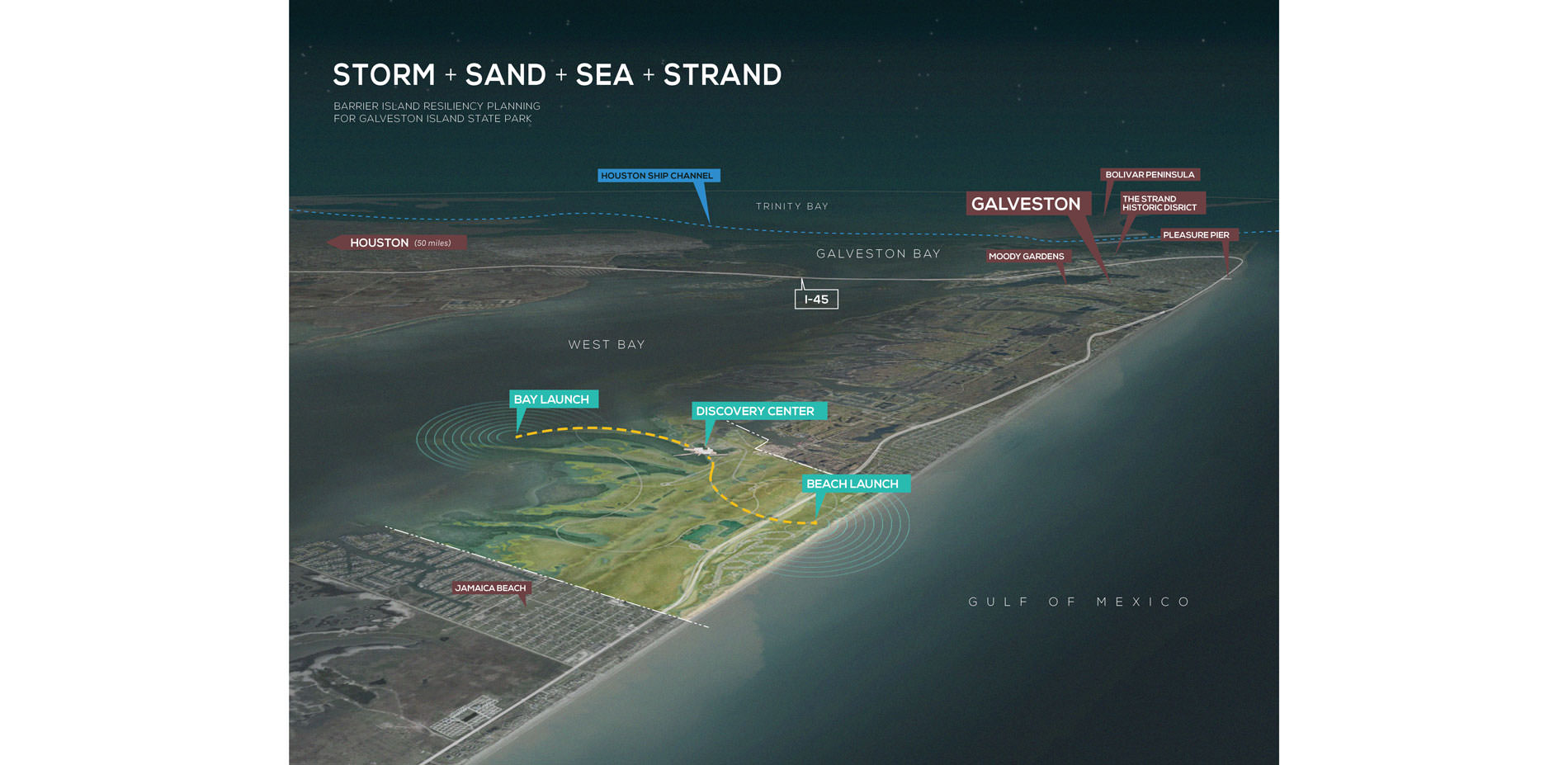
Barrier Island Discovery
Site selection for the park headquarters is paramount in achieving multiple project goals. A bay-side location is strategic for storm surge but demands a dramatic experience to entice beach-goers. As the launch point for interpretive experience, the Discovery Center is located at the confluence of land and water at an area that is already experiencing periodic flooding.
The plan decidedly rejects the concept of building atop the highest point on the site: a mound created for a failed 1980’s amphitheater endeavor. Instead, visitors gradually ascend the mound to the 21 foot elevation and traversing a bridge across the marsh to the Discovery Center. The elevated complex greets guests with unparalleled panoramic views that sweep from beach to bay. The broad deck educates visitors in one location and propels them to explore the site – reducing the dependency on signage clutter that erodes the sense of nature immersion.
Rather than simply a shell for exhibits, the Discovery Center tests and exhibits storm resiliency engineering and sustainable island construction practices that might be utilized elsewhere on the island (where no mound exists).
Trails immerse visitors in the overlapping storylines of the barrier island environment and educate them on the fragility of the site. Three “launch points” celebrate unique areas of the park (bay, marsh, and beach). Secondary loop trails offer exploration into subsets of site diversity and connect outdoor classrooms. The Transect Trail crosses the highway, physically connecting the two sides of the park, and terminates at the beach launch point. Strategically pulled back from the shore, the elevated observation platform offers foreground views across the freshwater swale, dune, beach, and on to the gulf beyond.