Award of Excellence
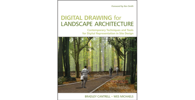
Digital Drawing for Landscape Architecture: Contemporary Techniques and Tools for Digital Representation in Site Design
Bradley Cantrell, ASLA and Wes Michaels, ASLA
Publisher: John Wiley & Sons, Inc.
 Close Me!
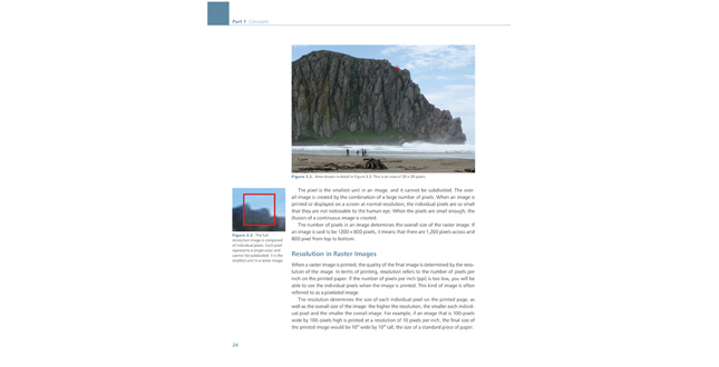
Figure 3.2. Area shown in detail in Figure 3.3. This is an area of 20 x 20 pixels.
Download Hi-Res ImageImage: Bradley Cantrell, ASLA and Wes Michaels, ASLA
Image 2 of 15
 Close Me!
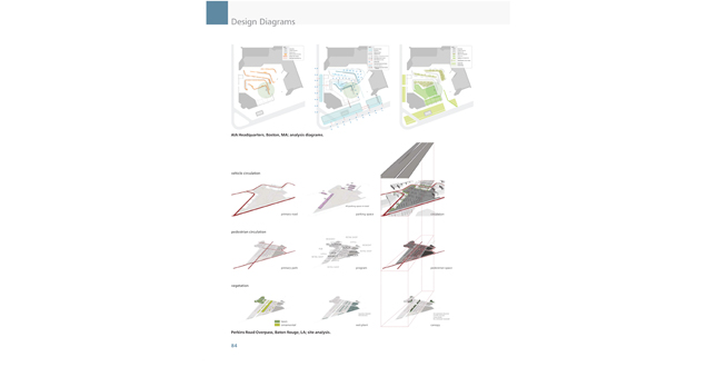
Design Diagrams.
Download Hi-Res ImageImage: Bradley Cantrell, ASLA and Wes Michaels, ASLA
Image 3 of 15
 Close Me!
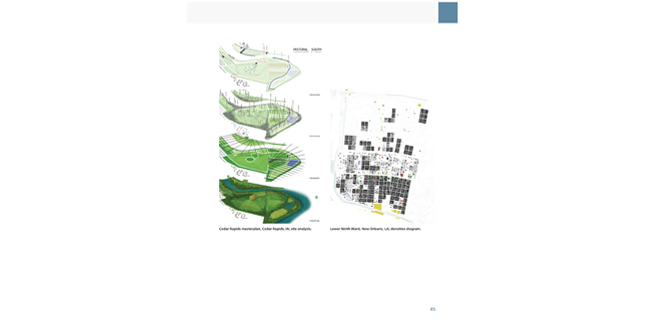
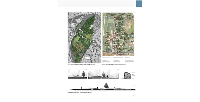
Cedar Rapids masterplan, Cedar Rapids, IA; site analysis. Lower Ninth Ward, New Orleans, LA; densities diagram.
Download Hi-Res ImageImage: Bradley Cantrell, ASLA and Wes Michaels, ASLA
Image 4 of 15
 Close Me!
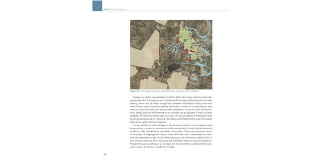
Figure 9.3. Active diagramming using illustrator transformation tools. Mexico City Studio.
Download Hi-Res ImageImage: Bradley Cantrell, ASLA and Wes Michaels, ASLA
Image 5 of 15
 Close Me!
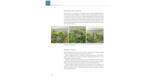
Figure 9.6. Complex representations can be distilled in order to highlight specific components necessary to support a design narrative.
Download Hi-Res ImageImage: Bradley Cantrell, ASLA and Wes Michaels, ASLA
Image 6 of 15
 Close Me!
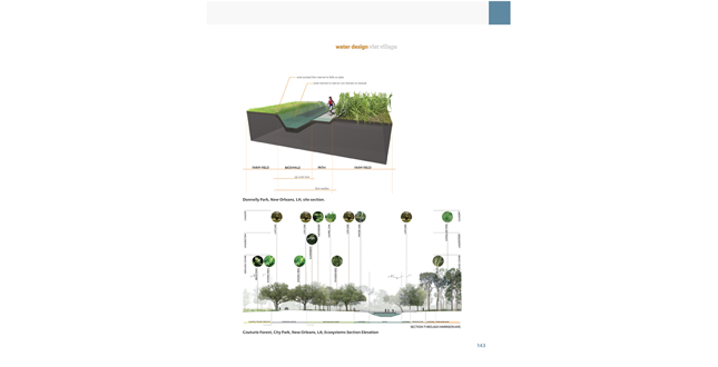
Couturie Forest, City Park, New Orleans, LA; Ecosystems Section Elevation.
Download Hi-Res ImageImage: Bradley Cantrell, ASLA and Wes Michaels, ASLA
Image 8 of 15
 Close Me!
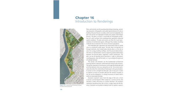
Figure 16.1 AutoCAD and Photoshop site plan; Soundview Park, Bronx, NY.
Download Hi-Res ImageImage: Bradley Cantrell, ASLA and Wes Michaels, ASLA
Image 9 of 15
 Close Me!
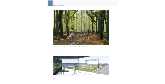
Top: Couturie Forest, City Park, New Orleans, LA; pathway through forest perspective. Bottom: Bridge park Competition, Buzzard’s Bay, MA; overlooking levee perspective.
Download Hi-Res ImageImage: Bradley Cantrell, ASLA and Wes Michaels, ASLA
Image 10 of 15
 Close Me!
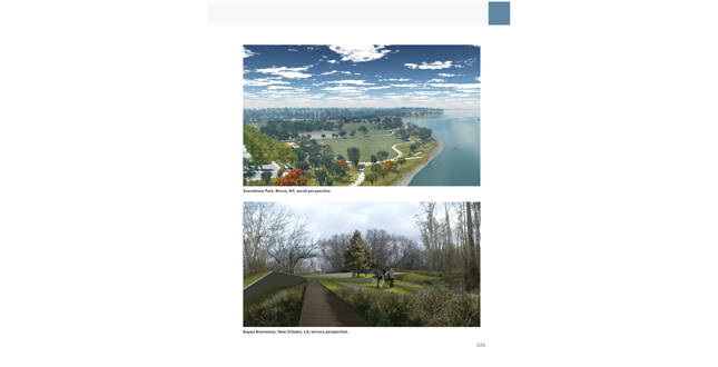
Top: Soundview Park, Bronx, NY; aerial perspective. Bottom: Bayou Bienvenue, New Orleans, LA; terrace perspective.
Download Hi-Res ImageImage: Bradley Cantrell, ASLA and Wes Michaels, ASLA
Image 11 of 15
 Close Me!
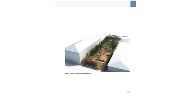
Growing Home, New Orleans, LA; aerial perspective.
Download Hi-Res ImageImage: Bradley Cantrell, ASLA and Wes Michaels, ASLA
Image 12 of 15
 Close Me!
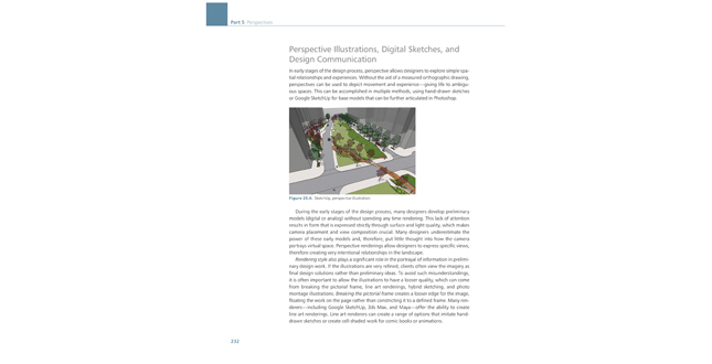
Figure 25.4 SketchUp, perspective illustration.
Download Hi-Res ImageImage: Bradley Cantrell, ASLA and Wes Michaels, ASLA
Image 13 of 15
 Close Me!
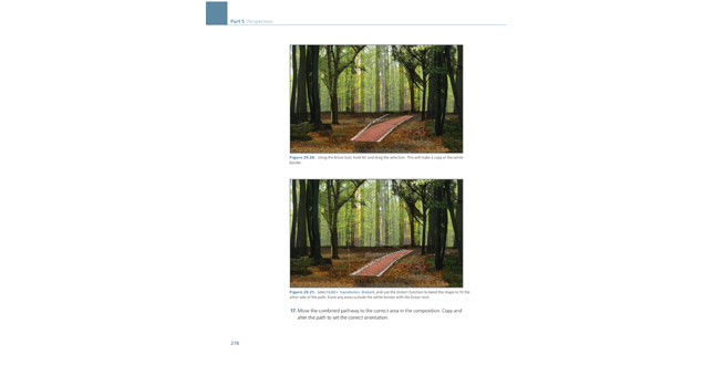
Top: Figure 29.20. Using the Move tool, hold Alt and drag the selection. This will make a copy of the white border. Bottom: Figure 29-21. Select Edit>Transform>Distort, and use the Distort function to bend the shape to fit the other side of the path. Erase any areas outside the white border with the Eraser tool.
Download Hi-Res ImageImage: Bradley Cantrell, ASLA and Wes Michaels, ASLA
Image 14 of 15
 Close Me!
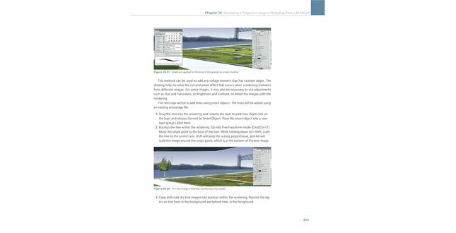
Top: Figure 40-32. Shading is applied to the base of the grasses to create shadow. Bottom: Figure 30.22 The tree images is inserted, positioned, and scaled.
Download Hi-Res ImageImage: Bradley Cantrell, ASLA and Wes Michaels, ASLA
Image 15 of 15
Project Statement
Digital Drawing for Landscape Architecture is a book about bridging analog and digital landscape representation techniques. Digital landscape representation relies heavily on the past, and we attempt to tie past and present together. The book is intended to highlight examples, explain techniques, and provide context for how we use digital media as designers and landscape architects.
Project Narrative
—2012 Professional Awards Jury
Digital Drawing for Landscape Architecture: Contemporary Techniques and Tools for Digital Representation in Site Design is the product of many years of professional practice and teaching. As designers, we attempted to create a book that focused on getting the job done. In this sense, each section tackles the basics of the subject matter and each chapter introduces a short background with an explanation of how to accomplish a phase of the representation process with current digital tools. Our inspiration comes from the books that introduced us to landscape architectural graphics, such as Grant Reid’s Landscape Graphics or Chip Sullivan’s Drawing the Landscape. Both books present the reader with techniques that are applicable to a specific topic with just enough background to explain how it fits within the larger profession. Our hope is that Digital Drawing for Landscape Architecture will serve as a contemporary, digital version of these books for landscape architecture professionals and students.
We come from a group of academics and professionals that did not take any formal digital media courses. Instead, we were taught analog mechanical drafting and drawing and then applied those skills to our interest in digital media. All of our skills come from exploration through trial and error. We learned that doing it the second or third time was always the most productive. Typically, we would jump into a project and begin to experiment. If we didn’t understand a tool, we opened the Help file or just started using it to see what happened. This book outlines techniques, but we encourage our readers to experiment. There are an infinite number of ways to get to the same solution, and it is important that each person find a way that works for him/herself.
Digital Drawing for Landscape Architecture is a book about the moment, bridging analog and digital techniques. Digital landscape representation relies heavily on the past, and we attempt to tie past and present together. We are consistently amazed at the work our colleagues and students produce, and our hope is that by putting out defined techniques, individuals will question and evolve these practices. In the long run, landscape representation will eventually begin to leave the conventions of the mechanically drafted orthographic drawing in favor of parametric modeling and geographic information systems. While these systems exist, they currently do not address the needs of site designers as creative design tools.
It is always a risk to base any book on specific software, but when techniques are introduced it is almost impossible to be completely software agnostic. It is possible to create amazing work with any software, but we focused on the tools we use everyday: Adobe Photoshop, Adobe Illustrator, 3ds Max, SketchUp, and Vectorworks or AutoCAD. These are not the only tools, but they are the ones we have evolved with over time and, therefore, feel the most comfortable using. While software does change, it has essentially been very consistent for the past 10 years. Features are added and refined, but the process has not been considerably altered through time. It is very easy to constantly chase the newest tools, but it is typically more productive to evolve our own processes with or in spite of the tools. Readers will find that most of the techniques discussed in this book will work in software versions that date back 5-10 years.
Digital Drawing for Landscape Architecture presents examples and techniques for each of the traditional design drawings: diagram, plan, section/elevation, and perspective. These drawings are the basis for all of our representation endeavors; and while we encourage experimentation in how these drawings evolve, it is important to recognize the need for measured drawings when working in digital media. The techniques also focus on speed and efficiency, which translates to getting a job done quickly, with the fewest mouse clicks, and being able to edit the drawing when necessary. Readers will find that almost every technique allows representation to be an iterative process, creating elements that we assume will be changed or modified. There is very little certainty within the design process and, therefore, it is essential that drawings remain flexible.
This book assumes that readers are versed in basic representation concepts and computing principles. The book spends a small amount of time discussing how computing affects the representation process and the basics of each piece of software, but it is not intended as an introduction to any particular piece of software. There are many great books that catalogue and explain each feature of the software.
The book is intended to highlight examples, explain techniques, and provide context for how we use digital media as designers. Readers are free to start at the beginning or jump around to areas of interest; either method is suitable to take advantage of the information. We hope the reader will take away something new and contribute back to others with new and interesting techniques.
Project Resources
LSU Robert Reich School of Landscape Architecture


