Honor Award
Governors Island Park and Public Space Master Plan
New York City
West 8 Urban Design & Landscape Architecture, P. C., New York City
Client: The Trust for Governors Island
 Close Me!
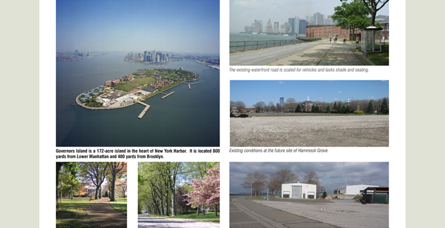
Governors Island is a 172-acre island in the heart of New York Harbor. It is located 800 yards from Lower Manhattan and 400 yards from Brooklyn.
Download Hi-Res ImageImage: West 8 and Aerial by Andrew More
Image 2 of 16
 Close Me!
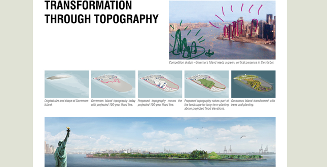
Transformation Through Topography. Governors Island transformed.
Download Hi-Res ImageImage: West 8
Image 3 of 16
 Close Me!
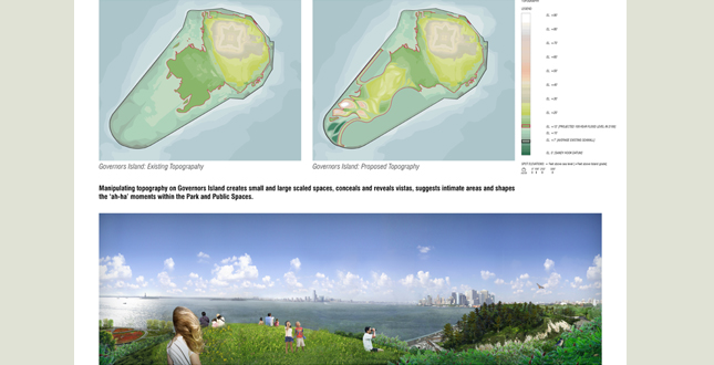
Manipulating topography on Governors Island creates small and large scaled spaces, conceals and reveals vistas, suggests intimate areas and shapes the ‘ah-ha’ moments within the Park and Public Spaces.
Download Hi-Res ImageImage: West 8
Image 4 of 16
 Close Me!
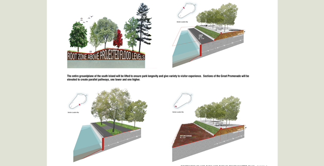
The entire groundplane of the south Island will be lifted to ensure park longevity and give variety to visitor experience. Sections of the Great Promenade will be elevated to create parallel pathways, one lower and one higher.
Download Hi-Res ImageImage: West 8
Image 5 of 16
 Close Me!
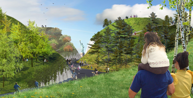
The Hills draw visitors towards the Harbor and frame views.
Download Hi-Res ImageImage: West 8
Image 6 of 16
 Close Me!
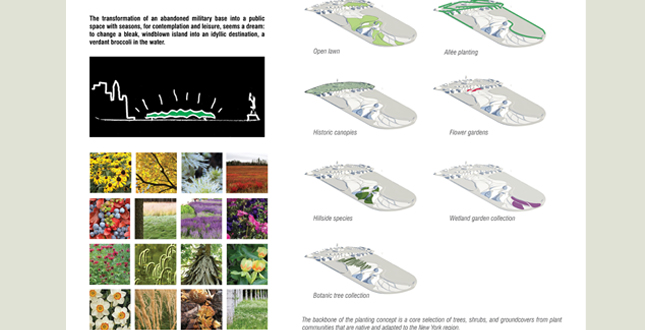
A Green Island. The transformation of an abandoned military base into a public space with seasons, for contemplation and leisure, seems a dream: to change a bleak, windblown island into an idyllic destination, a verdant broccoli in the water.
Download Hi-Res ImageImage: West 8
Image 7 of 16
 Close Me!
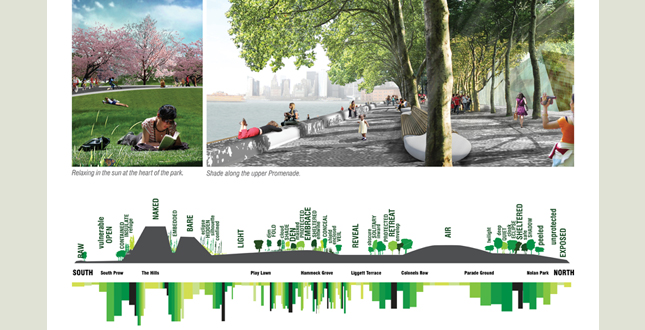
The experiential quality of light and shade establishes a noticeable rhythm across the Island.
Download Hi-Res ImageImage: West 8
Image 8 of 16
 Close Me!
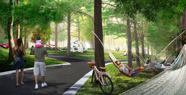
Hammock Grove has shade, lawns and hammocks for relaxing. Custom bicycles reinforce the park narrative.
Download Hi-Res ImageImage: West 8
Image 9 of 16
 Close Me!
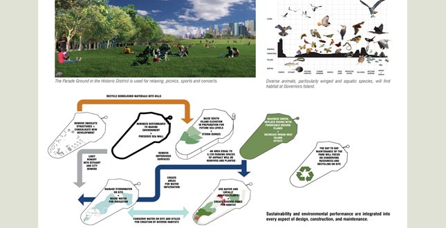
Sustainability and environmental performance are integrated into every aspect of design, construction, and maintenance.
Download Hi-Res ImageImage: West 8
Image 10 of 16
 Close Me!
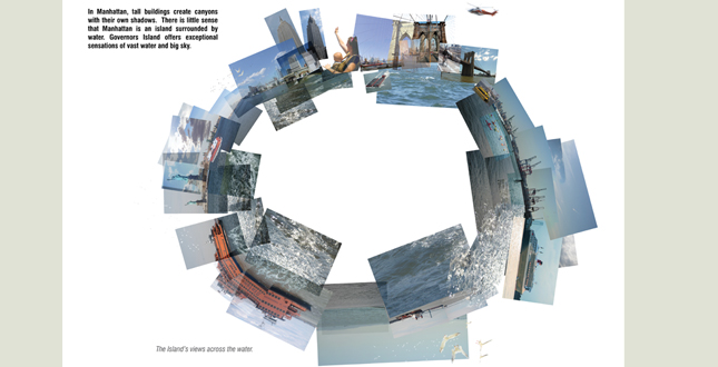
An Island Like No Other. In Manhattan, tall buildings create canyons with their own shadows. There is little sense that Manhattan is an island surrounded by water. Governors Island offers exceptional sensations of vast water and big sky.
Download Hi-Res ImageImage: West 8
Image 11 of 16
 Close Me!
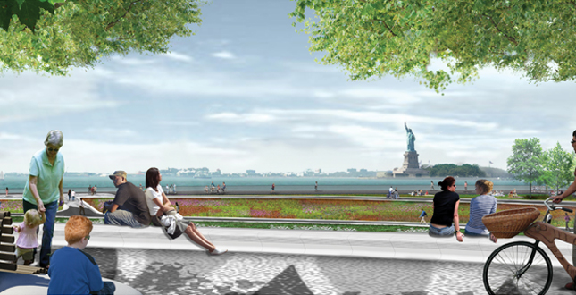
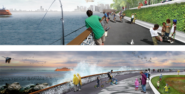
The design offers 360 degree visual experiences on the Island: one slowly shifting along the Great Promenade and the other providing surprise and drama from viewpoints on top of the Hills.
Download Hi-Res ImageImage: West 8
Image 12 of 16
 Close Me!
The 2.2 miles of the Great Promenade offer interesting views and experiences along the Harbor. A custom balustrade references marine life.
Download Hi-Res ImageImage: West 8
Image 13 of 16
 Close Me!
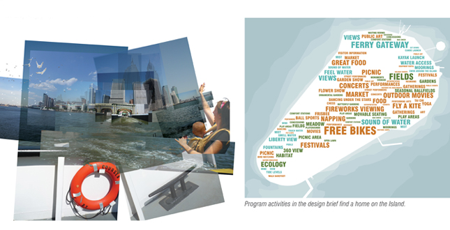
A Carefree Island. Governors Island embodies a special carefree spirit. The short journey by boat allows passengers to leave the City behind. The park and public space design preserves the Island as an oasis for bicycling, play, the arts and the imagination.
Download Hi-Res ImageImage: West 8
Image 14 of 16
 Close Me!
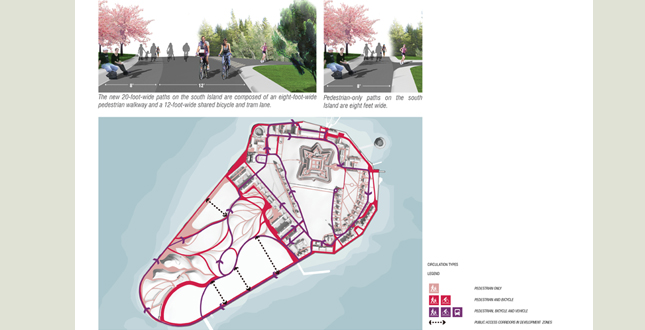
Clear, organized circulation is essential to the Island. While pedestrians, bicyclists and service vehicles all use the Island, the plan gives priority to pedestrians and bicyclists.
Download Hi-Res ImageImage: West 8
Image 15 of 16
 Close Me!
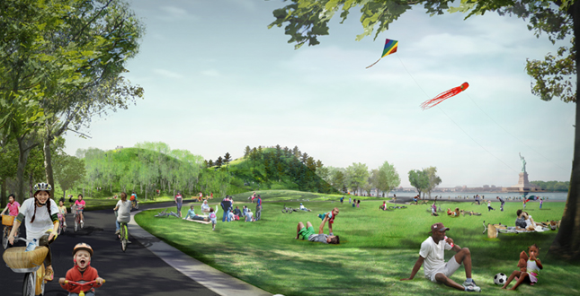
Bicyclists enjoy the inviting open spaces on the Island.
Download Hi-Res ImageImage: West 8
Image 16 of 16
Project Statement
The Governors Island Park and Public Space Master Plan proposes a dramatic transformation of this once-abandoned island and accentuates the qualities of this unique place, transforming Governors Island into both a destination and landmark. Governors Island offers a world apart from New York City, an extraordinary vantage point on New York Harbor, and the chance to experience the sensations of a green Island surrounded by water and sky.
Project Narrative
—2012 Professional Awards Jury
History and Context
The Lenape Indians, Dutch settlers, British military and U.S. Coast Guard all had substantial presence on Governors Island and influenced the rich cultural and physical history of the place. In the 20th century, the island was expanded with landfill from the Lexington Avenue subway line, increasing the Island's area from 69 acres to 172 acres. The US Army and Coast Guard's presence can be seen in the many vacant buildings on the site, and the existing site organization of circulation and planting.
The natural setting of Governors Island is paradoxical and a collection of unique micro climates in the context of the urbanization of New York City. At the Island’s edge, rapid changes in weather, strong currents and winds off the harbor are physically manifest in the lack of planting and hard edge of the seawall. The naturalistic setting of the North Island is, in contrast, serene and quiet.
Despite its central location only 800 yards from the tip of Manhattan, Governors Island was invisible to New Yorkers for two centuries. Inaccessible to the public, the Island became the ultimate exemplar of out-of-sight, out-of-mind. This perception began to shift in 2003, when President Bush designated 22 acres of the north Island as a National Monument that is now managed by the National Park Service (NPS). The remaining 150 acres were deeded to the Governors Island Preservation and Education Corporation (GIPEC), now known as the Trust for Governors Island (TGI). Today, the Island is accessible by a free, 7-minute ferry ride from either Lower Manhattan or Brooklyn during the summer season.
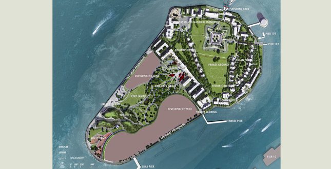
The Island’s deed restricts typical residential housing therefore the design team began the project with a truly vacant Island, which had no permanent tenants. Developed from the 2006 international design competition winning entry, the vision has since been developed into richly conceived and feasible Master Plan, which will serve as the catalyst and driver for the redevelopment of the Island. The Master Plan for the Governors Island Park and Public Spaces encompasses 87 acres. The landscapes of the northern Historic District total 33 acres and the new Park and Public Spaces to the south total 40 acres. The Great Promenade, 2.2 miles in length, runs the complete periphery of the Island.
Analysis and Planning Process
Analysis was unique on this project. The design team spent hundreds of hours on the Island, in all types of weather and seasons, to understand and incorporate micro and macro site conditions. On both the large and small scale, design decisions were rarely made without a visit to the site to test assumptions. Data sources including maps, historical photographs and technical reports were leveraged and verified on site to underpin design ideas.
The re-imagining of the Island landscape goes hand-in-hand with its rediscovery by the people of New York City. In 2004 the Island was opened to the general public for the first time. By 2011, more than 448,000 people from all five boroughs visited and the Island has emerged as a major festival and event space, weekend destination and tourist draw within the New York region.
The design team observed visitors’ use to inform the Master Plan. Concepts as simple as moveable furniture and as complex as the logistics of ferry queuing, servicing and disembarkation were all informed by empirical research and direct observation. The design team was on site numerous times a week and meetings with the client were often conducted in-situ, using mockups and real site conditions to test ideas. Actual events were mapped and analyzed to develop future scenarios and to assess their potential for implementation. This constant process of observation and feedback continues to inform the design and planning process through construction documentation.
Many of the successful programming strategies evolved from the Master Plan and were tested during the summer season: free bikes, a grand waterfront promenade, and a care-free experience. By expanding public access and early uses, the team engaged a broad public base of different users. Thousands of New Yorkers contributed ideas about what they would like to see in the park and public spaces and are incorporated into the Plan: hammocks for napping, habitat for birds, fields for sports and bicycles available for everyone’s use.
Planning Principles and Design Strategies
The planning principles and design strategies are rooted in a deep understanding of the Island’s inherent attributes and its potential as a resource for the entire region.
Transformation through Topography
The foundation for the Master Plan is transformation through topography in the tradition of Prospect and Central Parks. The Master Plan dramatically sculpts the flat and utilitarian southern part of the Island to create a landscape with a rich array of experiences and settings for plants and people. As the visitor traverses from north to south, an undulating groundplane choreographs the park experience through framed views, enclosure, and a sense of drama. The new topography curves and weaves, providing small high points within the landscape, making the experience of the heart of the Island seem vast and providing the visitor with an appetite for exploration and discovery. The topography culminates in four green hills from which never-before-seen 360o panoramic views of the Brooklyn and Manhattan skylines are revealed. Raising and sculpting the topography in the southern part of the Island knits together the entire Island, while also armoring new parkland against the predicted effects of flooding and rising sea levels.
A Green Island
The Master Plan calls for the Island to be a green skyline in the harbor. The existing southern part of the Island has a patchwork of parking lots and roads, with a collection of struggling trees, while the northern part of the Island suffers from an overabundance of disorienting asphalt pathways and loading zones. The Master Plan provides a strategy for increasing softscape by the removal of redundant hardscape associated with vehicles and parking, in addition to providing new lawns, gardens, wetlands and groves. More than 1,300 new trees will be planted, adding to the 1,700 trees already on-site. Plant selection will focus on native and locally-adapted species expected to thrive as weather patterns in the region change. The qualities proposed in the Master Plan are a true transformation for the existing desolate spaces. Intrinsic to this vision are regenerative strategies for managing stormwater, recycling and a vision of park longevity that is remarkable in its ambition.
An Island Like No Other
Governors Island is truly an island like no other, with a unique vantage point on the New York Harbor, its icons and a treasured historic landscape. The Master Plan provides many places to revel in the sensual experiences of water and sky in addition to providing enclosure, refuge and escape within the heart of the Island. The design offers two 360o experiences: one slowly unfolding as the visitor circumnavigates the Great Promenade, the other providing surprise and drama as the visitor ascends to the summit of the hills. The design team reinforced the location of the Island in the design of park-wide custom details. For example, paving patterns convey an abstraction of aquatic forms. Furnishings such as bicycles, seating and the balustrade provide opportunities to experience the harbor in different ways. This customized narrative provides a richness of ornamentation that highlights the landscape experience and celebrates this landscape tradition.
A Carefree Island
Governors Island embodies a special carefree spirit and visitors remark that a visit is like a vacation. The short journey by boat allows passengers to leave the worries and sensations of the City behind. The Park and Public Space design protects the Island as an oasis of car-free bicycling, play, the arts and the imagination. The many kinds of spaces — garden, terrace, wetland, lawn and grove — offer room for passive recreation, leisure and serenity to coexist with play and gathering. Pathways are designed for bicycling at slow speeds with viewsheds hiding and revealing the icons of the harbor while alternating the refuge of the park with the enormity of the sky.
Regenerative Design
Sustainability, feasibility and longevity underpin the Governors Island Master Plan. Creating 87 acres of green space on Governors Island and making this park publicly accessible to millions addresses larger goals for the long-term livability and sustainability of cities. In the physical design of the Park and Public Spaces, it was important to do more than simply turn asphalt into lawn; these spaces are designed to thrive for generations. The park is designed to absorb the effects of climate change and projected sea level rise. Site-specific strategies are employed that consider soils, groundwater, flooding, air quality, habitat and urban heat-island effects.
The creation of new topography on the Island and the planting design specifically addresses the concerns of climate change by lifting the entire groundplane, creating a park above the elevation of the projected 100-year flood in the year 2100. These raised areas, and the enrichment of soil conditions, provide sustainable habitat for trees and other plantings to thrive. The new topography will reuse on-site materials from demolished buildings and parking lots, keeping those materials out of existing landfills. The replacement of acres of impervious asphalt with softscape, plantings and permeable paving reduces stormwater runoff, maximizes infiltration and decreases the urban island heat effect. Combined with a system of collection and reuse on-site, stormwater will be collected rather than flowing directly into the Harbor and City sewers.
The overarching planting strategies include the use of native plants, planting to micro-climatic conditions and specifying appropriate soil depths. The Master Plan envisions the development of complex plant communities that will provide healthy habitat for many winged and aquatic species, adding Governors Island to a network of regional habitat corridors.
Implementation and Development
The physical transformation of Governors Island will happen in phases. In the context of Island-wide redevelopment, the Park and Public Spaces are the first step of a longer-term strategy that seeks to enliven the Island with new tenants — both in the existing structures on the northern part of the Island and new development on the southern part of the Island.
The Park and Public Space Master Plan helped initiate a comprehensive capital improvement program. The process enabled the numerous stakeholders involved to coalesce around a unified goal and schedule for implementation. By identifying key issues early on and defining them in the Master Plan, the design team helped enable these efforts, streamlining the implementation process. Potable water, seawall repair, historic building stabilization and Island-wide infrastructure improvements are now funded and underway. In 2013, the Island will be home to 30 new acres of park and public space and additional renewed public space in the Historic District.
Project Resources
Lead Landscape Architects and Master Planners: West 8
Principal, Design Director: Adriaan Geuze, International ASLA
Principal-in-Charge: Jamie Maslyn Larson, ASLA
Design Team: Claire Agre ; Ela Chojecka; Jerry van Eyck; Pieter Hoen; Chia-Ying Lin; Rachel Laszlo Tait; Perry Maas; Marco van der Pluym; Ronald van Nugteren; Matthew Skjonsberg; and Joris Weijts


