Award of Excellence
An Emerging Natural Paradise — Aogu Wetland Forest Park Master Plan
Taiwan
National Sun Yat-sen University, Kaohsiung, Taiwan
Client: Forestry Bureau, Council of Agriculture, Executive Yuan, Taiwan
 Close Me!
Master Plan
Download Hi-Res ImageImage: National Sun Yat-sen University, Yannlin Photo, Forestry Bureau
Image 1 of 16
 Close Me!
AOGU Wetland and Forest Park, Taiwan
Download Hi-Res ImageImage: National Sun Yat-sen University, Yannlin Photo, Forestry Bureau
Image 2 of 16
 Close Me!
Site Location
Download Hi-Res ImageImage: National Sun Yat-sen University, Yannlin Photo, Forestry Bureau
Image 3 of 16
 Close Me!
Site History
Download Hi-Res ImageImage: National Sun Yat-sen University, Yannlin Photo, Forestry Bureau
Image 4 of 16
 Close Me!
Project Issues
Download Hi-Res ImageImage: National Sun Yat-sen University, Yannlin Photo, Forestry Bureau
Image 5 of 16
 Close Me!
Vision for Augo Wetland and Forest Park
Download Hi-Res ImageImage: National Sun Yat-sen University, Yannlin Photo, Forestry Bureau
Image 6 of 16
 Close Me!
Planning Process
Download Hi-Res ImageImage: National Sun Yat-sen University, Yannlin Photo, Forestry Bureau
Image 7 of 16
 Close Me!
Zoning Strategies
Download Hi-Res ImageImage: National Sun Yat-sen University, Yannlin Photo, Forestry Bureau
Image 8 of 16
 Close Me!
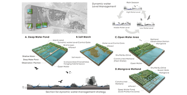
Passive Conservation Strategies
Download Hi-Res ImageImage: National Sun Yat-sen University, Yannlin Photo, Forestry Bureau
Image 9 of 16
 Close Me!
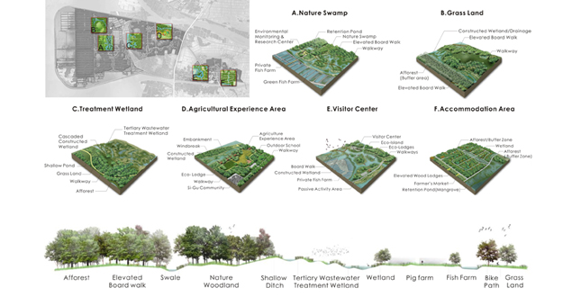
Active Conservation Strategies
Download Hi-Res ImageImage: National Sun Yat-sen University, Yannlin Photo, Forestry Bureau
Image 10 of 16
 Close Me!
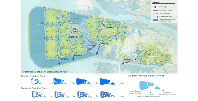
hydrological Strategies —Water Resources Management
Download Hi-Res ImageImage: National Sun Yat-sen University, Yannlin Photo, Forestry Bureau
Image 11 of 16
 Close Me!
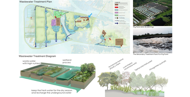
Hydrology Strategies — Wastewater Management
Download Hi-Res ImageImage: National Sun Yat-sen University, Yannlin Photo, Forestry Bureau
Image 12 of 16
 Close Me!
Planting Strategies
Download Hi-Res ImageImage: National Sun Yat-sen University, Yannlin Photo, Forestry Bureau
Image 13 of 16
 Close Me!
Future Scenario
Download Hi-Res ImageImage: National Sun Yat-sen University, Yannlin Photo, Forestry Bureau
Image 14 of 16
 Close Me!
Project Phasing
Download Hi-Res ImageImage: National Sun Yat-sen University, Yannlin Photo, Forestry Bureau
Image 15 of 16
 Close Me!
Impementation
Download Hi-Res ImageImage: National Sun Yat-sen University, Yannlin Photo, Forestry Bureau
Image 16 of 16
Project Statement
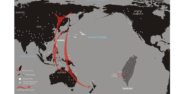
Aogu is a 1,600-hectare site located on the route of Asian migrating birds. The site has been reclaimed from the sea and unexpectedly reverted to a coastal wetland because of land subsiding and the cessation of farming in the area. The project focuses on establishing a series of re-habitation strategies on site that is reclaimed for human development, and emphasizes the site as a seeding process for the natural systems, as well as environmental education and eco-tourism.
Project Narrative
—2011 Professional Awards Jury
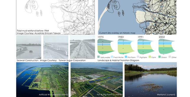
Over the past decades, flat and spacious coastal areas have been seen various usages and development. The contention and conflict between human development and natural conservation along the coastal area occur all around the world. The project, Aogu Wetland and Forest Park, is located in the southwest area of Taiwan, and has experienced different stages of development before it eventually reverted to natural wetland. On the estuary of the Bei-Gang River, the site was a typical tidal mud wetland before 1964. The site began the C-shaped seawall construction and reclaimed over 1,000-hectare of lands from sea in 1964 because of the farming and livestock industry. Historically, the land was desalinated and prepared for a sugar plantation, a pig farm and a fish farm. After the land subsided and several serious inundation events by the sea occurred, the soil become saline and the production of sugar ceased on the site. In 2001, the site was selected as an afforestation area. The landscape and habitat have changed dramatically in the past 40 years, and the site now consists of a combination of natural wetland and artificial woodland. The Aogu Wetland and Forest Park comes from this changing process of environment.
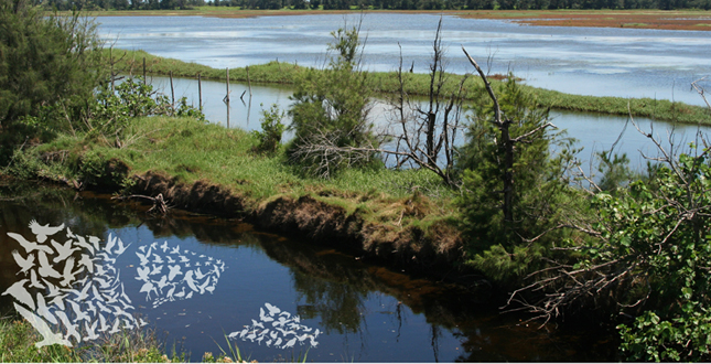
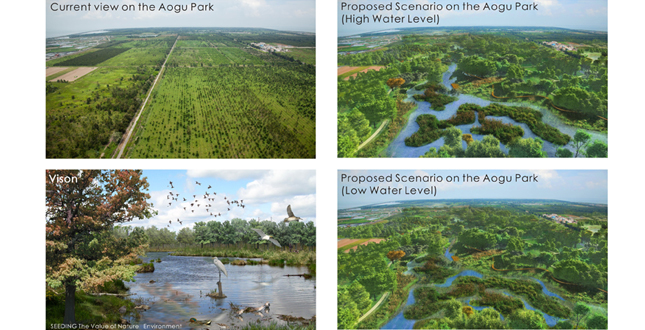
Aogu Wetland and Forest Park is the showplace of the process of natural systems. The site has been reclaimed and reverted back to a coastal wetland, which unexpectedly has become a refuge for migratory birds and other wildlife. The aim of this project focuses on establishing a series of conservation and re-habitation strategies on sites reclaimed for human development, and emphasizes the site as a seeding process for the natural systems, as well as environmental education, eco-tourism and cultural sustainability.
Project Issues
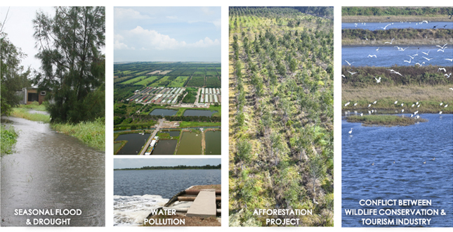
- Seasonal Flood and Drought: The site is still enclosed by a C-shaped seawall with the challenge of land subsiding. The rainfall during typhoon season can reach 300-500 mm per month, and create the major flood issue. During the drought season, the shortage of fresh water challenges the survival of wetland and forest habitat.
- Water Pollution: In the Aogu Wetland and Forest Park, is a pig farm with 30,000 pigs. The wastewater from the pig farm is treated by a secondary treatment plant, but the outflow from the plant and other untreated wastewater from surrounding fish farms and villages create major problems to the wetland and forest park.
- Afforestation Project: Based on the economic purpose, the afforestation project planted single species in each 100 by 400 meter land plot from 2001 to 2009. The artificial woodland with low diversity and natural habitat faces the critical issue of natural succession in the changing environment.
- Conflict between Wildlife Conservation and the Tourism Industry: The Aogu Wetland and Forest Park is becoming famous because of the number of migrating birds in the past few years. Unregulated tourism activities create major conflicts and environmental impacts to the wetland and forest habitats.
The Aogu Wetland and Forest Park master plan aims to use methods with the least impact to resolve the environmental problems and restore the natural habitats for various types of waterfowl and wildlife. The main concept for this project is returning, keeping, and recreating this site to its environmental and educational values.
Analysis and Planning Process
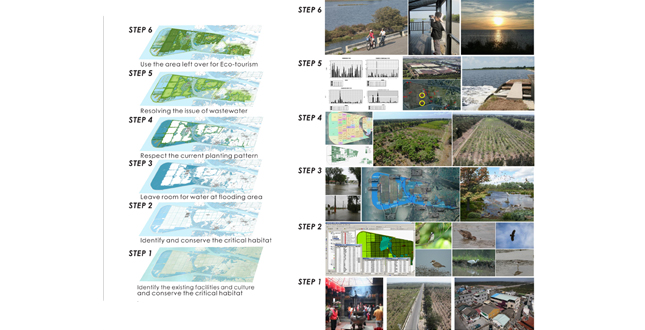
The Aogu Wetland and Forest Park faces complicated hydrological and natural environmental systems. The master plan is the result of a sequence of physical surveys, suitability analyses, and planning processes describing the following: 1) identify the existing facilities and culture; 2) identify and conserve the critical habitat; 3) leave room for water at flooding area; 4) respect the planting and natural pattern; 5) resolve the issue of wastewater; and 6) use the area left over for eco-tourism.
Conservational Strategies
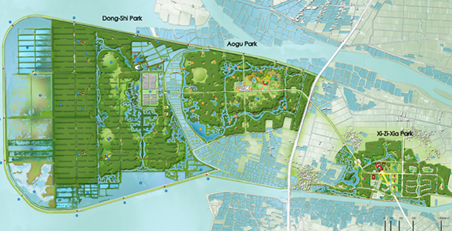
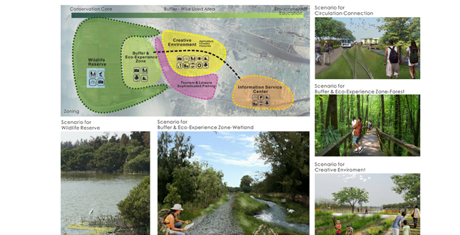
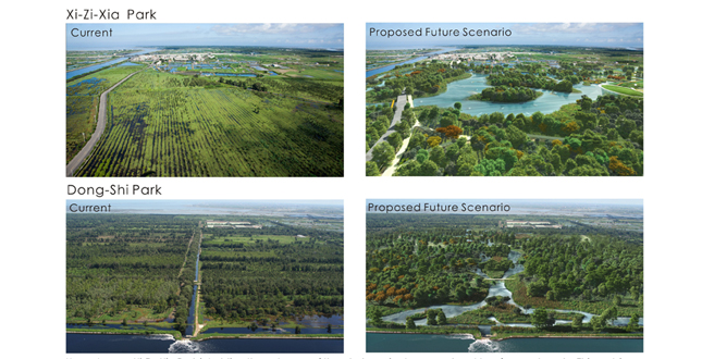
The conservation strategies are designed based on environmental sensibility in various areas. The western site of the park (Don-Shi Park) is the conservation core area with strict conservation policies. The middle part of the park (Don-Shi Park) plays the buffering role and provides services to natural species, villagers, and visitors. The eastern part of the park (Xi-Zi-Xia Park) is the entrance of the park with less environmental sensibility, but of high value in regard to education and demonstration. The main concept of the conservation is to restore and re-populate various types of habitats to recreate various eco-systems that existed here historically. In the master plan, marsh, mangrove, mud flat, open water, salt mud, ditches, woodland, grass land, wild farm, fishing ponds, etc., are merged into the wetland and forest park.
Hydrological Strategies
Freshwater is scarce at the site. Therefore, keeping all available fresh water on site has been the guideline for the hydrological strategies, except the storm rainfall intensity is higher than design standard. Since the rain is unevenly distributed over the year, various types of wetlands have been designed for maximizing utilization of the available freshwater sources. A flood-detention pond at the center of the Don-shi Park, which is capable of storing the 0.3 million cubic meters of storm rainfall runoff that comes only once or twice a year. Domestic discharges and farm disposals are collected through drainage ditches, purified through a set of constructed wetlands, and stored in the detention pond during the dry season. This will play the most important role in keeping the proposal green and viable.
Planting Strategies
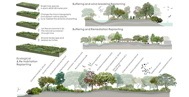
Due to the afforestation project, the low diversity of the woodlands, and several species are not in a healthy condition because of the salty and wet soil. The master plan alters the micro-topography, and uses the native species to recover the afforestation area gradually. The planting strategies include ecological replanting, buffering replanting, wind-breaking replanting, and historical-replanting strategies. The master plan focuses on the emerging coastal environment strategically with the following sequence: 1) get detailed surveys of the tree species in each 100 by 400 meter land plot; 2) create micro-topography changes and replant native species to re-habitat the diversity of planting; 3) allow the environment return to the natural succession through time; and 4) merge diverse landscape and related activities.
Zoning Strategies
The Aogu Wetland and Forest Park is zoned with the idea of green gradient. The park is planned for more environmental diversity, with strict and higher protection guidelines from east to west sides of the site. The park can be divided into three major parks. From west to east are Don-Shi Park, Don-Shi Park and Xi-Zi-Xia Park sequentially. Don-Shi Park has the highest diversity and is the core for conservation. The plan is to alter the artificial channel to natural waterways and various wetlands for restoring the most possible rainfall runoff during the wet season and purifying all available disposals to support the emerging diverse habitats. Aogu Park has a small village (300 people) in its center. This park acts as a Wise Use Area in the master plan. People living in this area can practice their fishing farm in a sustainable way, and use this area as a center for outdoor education. A ring-wetland system will be connected through created waterways around the village to protect it from flooding and treating the domestic disposals. Water will be circulated within the ring by using the flood drainage pumps to maintain creativities and biodiversity during the dry season. Xi-Zu-Xia Park is holding the entrance of the whole project area and is next to a famous temple. This park is a public access area with a deep open water park in the master plan. The visitor’s center will be floating on the water, letting visitors experience the natural environment and become educated before going into the park with high environmental sensitivities. Basic services and facilities can be provided to the public. Local people can use this area to set up their commercial development and services to the whole project area eventually.
Implemental Strategies
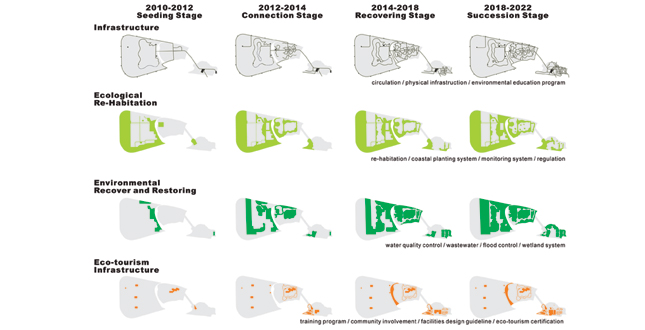
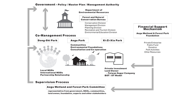
The master plan is developed through a serious public involvement, meetings, and consultations with experts that helped identity key issues and shape the planning process. The master plan includes phasing strategies with the least input regarding significant issues, and let natural succession take over gradually within a monitoring, educational, and management framework. An organizational structure, including NGOs, communities, government, committees. etc., is provided in the master plan to facilitate and maintain the operation of the park.
Project Resources
National Sun Yat-sen University: Planning and Design
Prof. Shiau-Yun Lu, International ASLA; Prof. Lei Yang; Prof. Jason Yu; Prof. Hsueh-Wen Chang; Prof. Yuen-Po Yang; Prof.Ming-Rea Kao; Hsiang-Hsiang Wang; Shau-Fu Wang; Hsin-Pei Wang; Jheng-Ru Li, Student Affiliate ASLA; Shin-Chia Chiu, Student Affiliate ASLA; Shu-Ting Shang; Hui-Yin Lin; Ying-Chieh Lin; Chen-Wei Wu; Shih-Yeu Hou; Yi-Chun Chou; Chia-Wen Hsu; Yung Chen Hsu; Kai Tsao; Chen-Hao Chang; Kai Chu Yang; Yu Jie Zhan; Tzu-Lin Kuo; Tzu-Chieh Chen; Hsiao-Yu Hsieh; I-Chun Chien; Che-Wen Chien
National Sun Yat-sen University: Plant Species Investigation
Mo-Shih Tang; Chun-Kuei Liao; Hsien-Cheng Yu
National Sun Yat-sen University: Animal Species Investigation
Chiung-Chen Cheng; Yi-Ting Huang; Chiao Ting; Ming-Hung Hsu; Wei-Jia Wen; Chang-En Chou; Guan-Liang Kuo; Hao-Ying Hsu; Szu-Ting Hsu; Wei-Jan Weng; Hsien-Chung Lee
National Taitung University
Prof. Jen-Jiun Perng
LUP International
Shian- Po Liao; Pi-Chu Liu
Yannlin Photo
Min-Min Chen; Wei Min Li
Sasaki Associates
Michael Grove; Mark Reaves; Dennis Pieprez, Affiliate ASLA; Stephen Benz
Financial Assessment
Chien-Ju Teng
Photography on Birds
Yu-Hsien Lai; Yi-Lun Hou
Consultant
Prof. Robert L. France; Prof. Robert Brian Shutes;
Prof. Kuo-Chung Li; Prof. Tzu-Chao Chang; Prof. Cho-Ying Huang; Prof. Tzu-Yuan Chao; Prof. Ying-Hao Chiu; Prof. Ling-Yi Wu; Seen Hui Long; Prof. Monica Kuo


