Honor Award
Gowanus Canal Sponge Park™
Brooklyn, New York
dlandstudio, llc, Brooklyn, New York
Client: Gowanus Canal Conservancy
 Close Me!
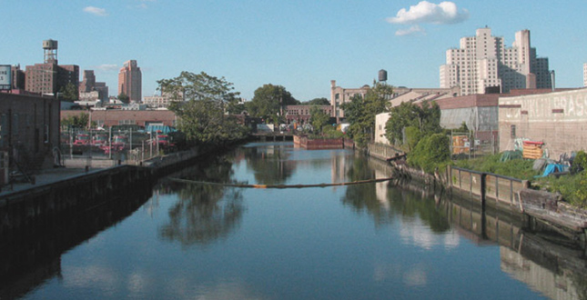
View of Gowanus Canal from Union Street Bridge. Gowanus Canal as it exists today and its natural beauty.
Download Hi-Res ImagePhoto: dlandstudio llc
Photo 3 of 17
 Close Me!
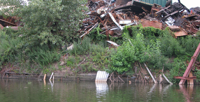
Gowanus Canal Bulkhead — Former industrial corridor has deteriorated due to lack of need for water transportation and years of neglect.
Download Hi-Res ImagePhoto: dlandstudio llc
Photo 4 of 17
 Close Me!
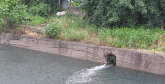
CSO’s of the Gowanus Canal — Over 1.1 million cubic meters of combined sewage is discharged into the canal annually.
Download Hi-Res ImagePhoto: dlandstudio llc
Photo 5 of 17
 Close Me!
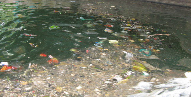
Polluted Gowanus Canal — Contaminants in the water include sewage from overflow of Combined Sewer Outfalls, industrial waste, and debris from surface rurnoff.
Download Hi-Res ImagePhoto: dlandstudio llc
Photo 6 of 17
 Close Me!
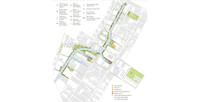
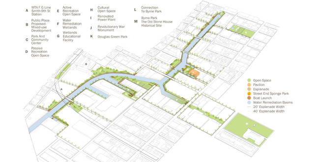
Site Axonometric — Linear esplanade along the edges of the Gowanus Canal interconnects proposed open spaces to existing recreational spaces, providing an urban waterfront park.
Download Hi-Res ImagePhoto: dlandstudio llc
Photo 8 of 17
 Close Me!
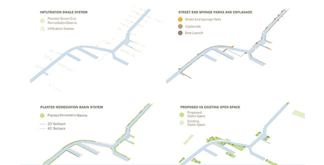
Water Remediation and Program Elements — Recreational programs and water remediation elements are distributed along the canal to promote diversity and activity along the length of the canal.
Download Hi-Res ImagePhoto: dlandstudio llc
Photo 9 of 17
 Close Me!
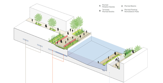
Street End Axonometric — Proposed programs include community gardens, dog runs, performance spaces, cafés, seating areas, boat launches and exhibition spaces.
Download Hi-Res ImagePhoto: dlandstudio llc
Photo 10 of 17
 Close Me!
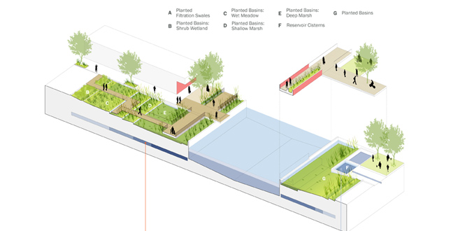
Street End Axonometric — Reservoir cisterns are connected to street sewer drains to divert excess street runoff. Collected water is distributed into the artificial wetland basins for remediation.
Download Hi-Res ImagePhoto: dlandstudio llc
Photo 11 of 17
 Close Me!
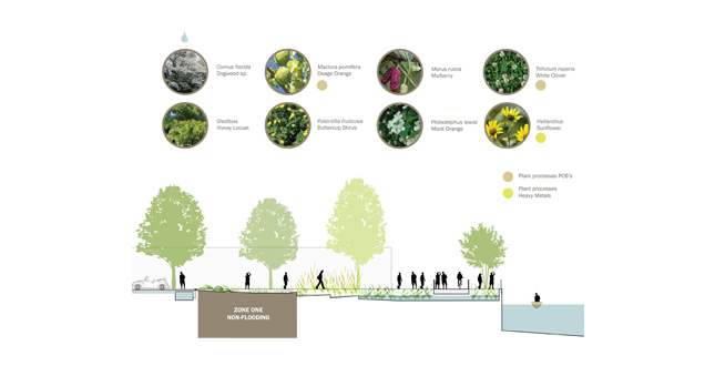
Sponge Park™ Phytoremediation — Zone One Non-Flooding
Download Hi-Res ImagePhoto: dlandstudio llc
Photo 12 of 17
 Close Me!
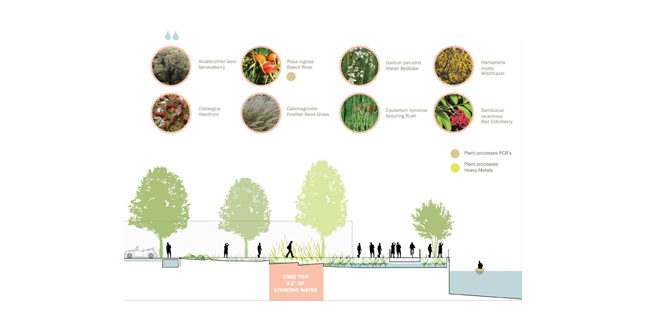
Sponge Park™ Phytoremediation — Zone Two 0–2" of Standing Water
Download Hi-Res ImagePhoto: dlandstudio llc
Photo 13 of 17
 Close Me!
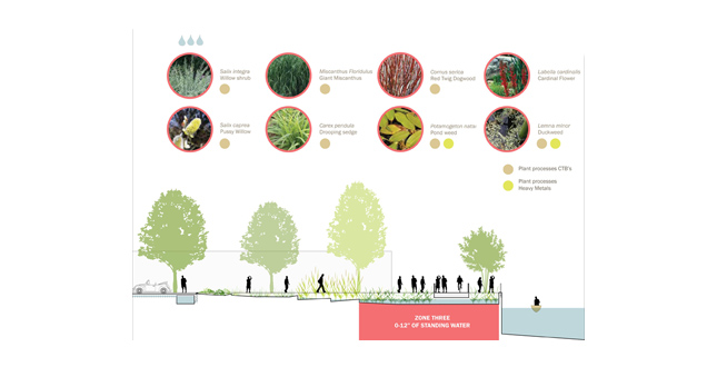
Sponge Park™ Phytoremediation — Zone Three 0–12" of Standing Water
Download Hi-Res ImagePhoto: dlandstudio llc
Photo 14 of 17
 Close Me!
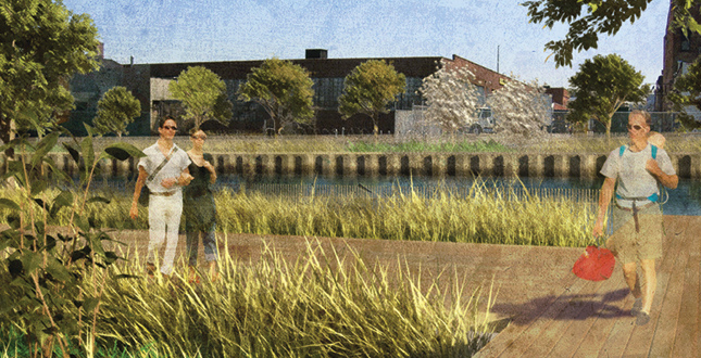
Street End Sponge Park™ at Sackett Street — Public street ends with limited use and access are transformed into artificial wetland parks with access to water.
Download Hi-Res ImagePhoto: dlandstudio llc
Photo 15 of 17
 Close Me!
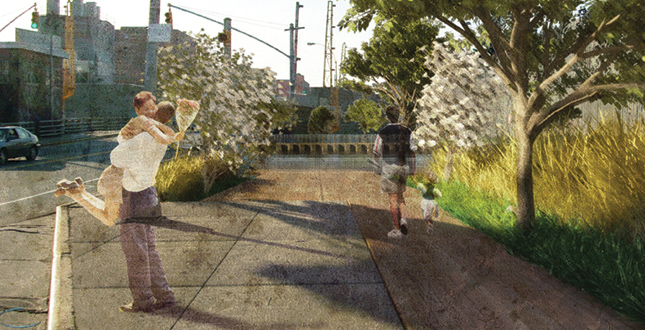
Sponge Park™ Entrance at 3rd Street — Public waterfront access is provided through interweaving pathways and planted remediation basins along the Gowanus Canal.
Download Hi-Res ImagePhoto: dlandstudio llc
Photo 16 of 17
 Close Me!
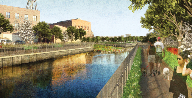
View of Esplanade from Carrol Street — Storm runoff water are remediated through artificial wetland basins, floating wetland remediation pads and restoration of natural wetlands in the existing turning basins.
Download Hi-Res ImagePhoto: dlandstudio llc
Photo 17 of 17
Project Statement
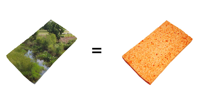
The Gowanus Canal Sponge Park™ is a multifunctional public open space system that slows, absorbs and filters surface water runoff to remediate contaminated water, activate the private canal waterfront, and revitalize the neighborhood. The proposal communicates a larger vision for environmental stewardship to a broad community through productive landscape strategies, collaboration among public and private constituencies, and an interactive design process that incorporates the input of residents, community groups, and city, state, and federal agencies.
Project Narrative
—2010 Professional Awards Jury
Years of exposure to industrial waste and water pollution has currently classified the Gowanus Canal as a New York State Saline Surface Water Quality Standard Class SD. Class SD water bodies are identified as dangerously polluted areas where activities such as fishing, swimming, and secondary contact are discouraged. This poor water quality is exacerbated by a lack of maintenance that has caused 85 percent of the canal bulkheads to erode, high cleanup costs, and minimal private investment. Recently, the U.S. Environmental Protection Agency began investigating the Gowanus Canal as a potential Superfund site.
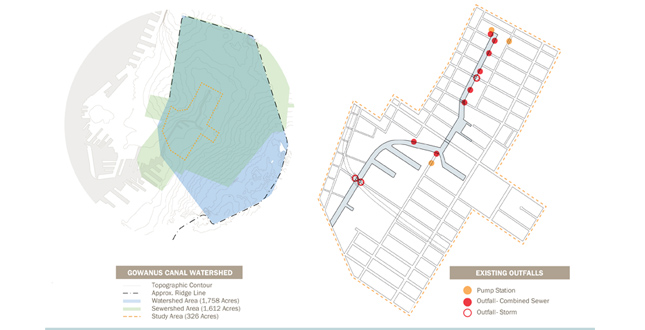
New York City has a combined sewer system. During storm events, rain falling within the Bergen watershed enters the storm drains and mixes with raw sewage in the sanitary sewer system. During heavy rainfalls, the combined sewage and stormwater overflow directly into the Gowanus Canal, discharging over 1.1 million cubic meters of combined sewage. Consequently, the Gowanus Canal remains listed on the New York State Section 303(d) list of impaired water bodies and is designated as a Track I Combined Sewage Overflow planning water body by the New York City Department of Environmental Planning. The innovative Sponge Park™ plan proposes diverting surface water runoff into a water management system and publicly accessible park that includes programmed urban outdoor space and vegetated landscape buffers to slow, absorb and filter the contaminated water, reduce the input of stormwater into the sewer system, and create an accessible public waterfront.
The Sponge Park™ plan proposes a strategy of urban stitching, connecting the public and private lands adjacent to the water, to create a continuous esplanade with recreational spaces spanning 1.5 miles along the canal. Existing public street ends serve as public entry nodes enabling public access to the esplanade and to the waterfront, as well as providing an open space network for community-oriented programs such as dog runs, community gardens, public exhibition spaces, and temporary markets. The proposed total area for the Gowanus Canal Sponge Park™ is 11.4 acres: 7.9 acres of esplanade and recreational open spaces, and 3.5 acres of remediation wetland basins.
The design also recognizes the cultural context of current and future resources by linking important historic sites, recreation areas, and neighborhood facilities. Important sites include the currently inaccessible Revolutionary War Memorial at the head of the canal, the Old Stone House in J.J. Byrne Park which was once connected by water to the Gowanus Canal, Thomas Green playground, Gowanus Dredgers boathouse and launch, and the historic waterfront itself. The use of remediation wetlands recognizes the natural history of the Gowanus watershed as a wetland creek. While the former marsh will not be restored to its 17th century state the plant communities and processes that historically helped control flooding and kept the Gowanus Bay clean will be reintroduced in a 21st Century adaptation.
Plants included in the design thrive at different levels of inundation, and draw heavy metals out of contaminated water. In addition, floating remediation wetlands and oyster beds would incorporate a mixture of aquatic organisms that work in concert to absorb or break down organic toxins, heavy metals, and over 21 viral bacteria found in the water. The Sponge Park™ utilizes multiple sustainable design elements in various facets and scales within the recently rezoned, 40-foot waterfront setback along the Gowanus Canal.
Research and data collection focused on urban water infrastructure. For urban water management, we researched existing urban sewer systems, watershed boundaries, aquatic plants plant communities, water contaminants, water remediation strategies, permeable materials, soil permeability and water related public programs.
The water analysis was divided into the following foci:
- Understanding existing urban rainwater runoff and sewer mechanics.
- Developing strategies to direct, collect and absorb excess storm water runoff.
- Determining how to clean stormwater runoff through phytoremediation.
- Strategies for restoring wetland habitat.
The urban analysis focused on the reality that many of the parcels are privately owned and have existing structures that conflict with NYC Department of Planning's proposed 40-foot setback. Our design creates a continuous path that is not reliant on a contiguous waterfront edge condition. Instead the circulation weaves in and out of the adjacent neighborhoods. The conflicts facilitate an intertwining esplanade and promenade that experientially stitches the Gowanus Canal waterfront to existing nearly adjacent recreational open areas such as Thomas Greene Park and The Old Stone House historical site.
It is important to recognize how significant development of the Gowanus Canal Sponge Park™ is to the future of urban infrastructure development. Water management within the Sponge Park™ design is based on reconfiguration of sewer and stormwater systems to reduce reliance on expensive engineered solutions that do not include generative vegetal and biological structures. In addition to its economic benefits, the Sponge Park™ system integrates stormwater management with the cultural context of important historic sites, recreation areas, and neighborhood facilities in a way that creates programmable urban open space while improving the environment. This environmental urbanism is a synthetic idea that can be implemented across the country. It is applicable to mature cities whose infrastructure is taxed by age and growth as well as in areas where industrial development has left behind inhospitable toxic landscapes. With the Sponge Park™, consideration of the environment becomes an integral part of the way the system functions. The flexible program of public spaces allows adaptation to site-specific program needs, and adds accessible urban open space to underserved neighborhoods. The design proposes realistic strategies for fixing broken infrastructure in a manner that supports the promise of a cleaner future.
This project is made possible with public funds from the New York State Council on the Arts, a state agency.
Project Resources
dlandstudio llc Design Team
Susannah C. Drake, ASLA, Principal
Yong K. Kim, Project Director
Lauren Barry, Designer
Anne Clark, Designer
Chris Davies, Designer
Rebecca Hill, Designer
Delia Kulukundis, Designer
Halina Steiner, Designer
Rachel Whiteside, Designer


