«previous pageANALYSIS & PLANNING CATEGORY
Honor Award
Brays Bayou Greenway Framework, Houston, TX
SWA Group, Houston, TX
client: Harris County Flood Control District
Project Statement
The Greenway Framework expands the flood-prevention strategies for Brays Bayou into an environmentally and culturally regenerative design and implementation strategy for a dynamic urban greenway. This visionary framework presents multifaceted solutions that simultaneously restore the surrounding habitat and offer urban recreation and education. It also identifies concurrent improvements planned by other entities in the Brays Bayou Corridor that, as a whole, will elevate Brays Bayou to national status as a large-scale, economically sustainable open-space destination.
Project Narrative
Goals
The Brays Bayou Greenway Framework is an urban design strategy that presents solutions for flood damage protection that equally serve the needs for urban recreation, habitat preservation, aesthetic beauty, and cultural enhancements. Its broad goals include:
- Reducing flood damage along Brays
- Creating high-quality regional open space and connections
- Improving and enriching the ecology of the project corridor
- Educating and serving citizens living along the bayou
The Brays Greenway Framework identifies a broad set of recreational and open-space opportunities along Brays Bayou. As a design tool, it simulates all possible trail alignments and connections as well as additional recreational and open-space amenities along Brays Bayou for more than 31 miles—from the mouth at Buffalo Bayou (the Ship Channel) to the Barker Reservoir (George Bush Park) in the west.
As a capital planning tool, the Brays Greenway Framework is designed to provide guidance to Enabling Agency and Brays Bayou Greenway partners, ensuring that as portions of the target programs and projects are initially implemented, the linkages and other objectives of the strategy are realized over time. The comprehensive implementation of program elements leads to a vision for the greenway that moves beyond its individual components and toward the creation of a cherished regional corridor.
Brays Bayou
Project Brays is a Local and Federal Government partnership to design and build increased flood protection as soon as possible. This is a $450 million flood-damage-reduction project to protect homes, businesses, and institutions along the length of Brays Bayou. The project aims to lower the flood water surface elevations along Brays Bayou by:
- Widening the channel from Fondren to the mouth (Buffalo Bayou and the ship channel turning basin)
- Replacing or lengthening low bridges to accommodate the widening
-
Building regional detention basins
Inputs
The Brays Greenway Framework evolved from Project Brays, and leverages the significant Federal money available for recreational development as a companion to the flood damage protection improvements. Thirty-one miles of the Brays Bayou channel were carefully inventoried. Manmade and natural systems were both documented in a mapped and linked database using GIS. Public workshops were held from one end of Brays to the other to discuss and draw a Brays "vision" and to prioritize community interest for a range of improvements.
Implementation and Monitoring
Recreation improvements are envisioned to be undertaken by community-based partners, with the first $45 million of those improvements being eligible for 50 percent reimbursement from the Project Brays budget. This $22.5 million is available through a Federal matching program to be used for recreational and open-space improvements along Brays Bayou and adjacent to the bayou, including selected tributaries.
To date, several million dollars of recreation projects have been started and/or completed by community partners including land acquisition, bridge constructions/enhancements, trail construction, landscaping, and other recreation amenities. These improvements are concentrated in the lower reaches of Brays Bayou, following behind the channel improvements constructed by Project Brays.
The Brays Bayou Greenway Framework will be updated every year to record the work accomplished in the preceding period. Partners (green groups, community groups, institutions, and corporations) responsible for making these incremental improvements will be recognized and their projects improvements illustrated in the new editions of the document. Eventually, the document is expected to form the basis of the Federal Recreation Plan, which will leverage $22.5 million in supplemental, recreational improvements on Brays Bayou.
Community Partnerships
As a community-based effort to leverage the work being done by Project Brays along the channel, partnership enhancements will be adopted and implemented by many communities or institutional organizations. Partners to date include universities, parks departments, greenspace advocacy groups, and private companies.
The Greenway Partnerships will contribute at all of these three levels:
- Connectivity: Providing links between neighborhoods and smaller segments along Brays, while also providing a connection for the entire length of the Bayou
- Culture and Identity: Acknowledging the sense of place for the immediate bayou and Brays Watershed, while also defining the greenway’s place within Houston and its surrounding region
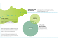
- Community: Offering interactive programs and improvements associated with bayou features and spaces that educate and celebrate the places that Brays tie together.
Project Resources
Project Team
Houston Parks Board
Houston Parks and Recreation Department
Harris County Precincts
Hermann Park Conservancy
Willow Waterhole Greenspace Conservancy
Client
Mike Talbott, Director
Raouf Farid, Project Manager
Additional SWA Group Team Members
Kevin Shanley, Lead Designer
James Vick
Scott McCready
Lance Lowrey
Trent McClain
Matt Baumgarten
Eli Lechter
The Brays Bayou Greenway Framework integrates the need for flood damage protection with the need for urban recreation, Habitat Aesthetics and Culture.
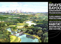
The Brays Greenway Framework was undertaken to understand all the possible trail alignments and connections as well as additional recreational and open space amenities along Brays Bayou from the mouth at Buffalo Bayou (the Ship Channel) to the Barker Reservoir (George Bush Park) in the west.
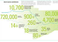
Project Brays Basic Modifications - Recreation Enhancements.
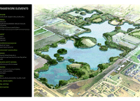
Stormwater Basins Drainage channels and detention basins provide important open space amenities. Like parkland, they are permanently dedicated open spaces. In addition to their flood control function, stormwater basins offer year-round recreational use except during brief periods of inundation. Because of their park-like qualities and proximity to Brays Bayou, four major detention facilities and one constructed freshwater marsh are a critical part of the Greenway Framework.

Framework Elements

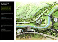
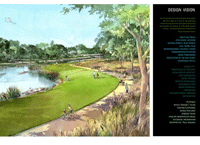
Design Vision The comprehensive implementation of program elements leads to a vision for the greenway which moves beyond its individual components and towards the creation of a cherished regional corridor. The following themes describe the Brays Greenway Vision
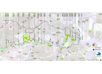
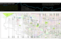
Brays Bayou Context Map - The bayou (colored in blue) runs from its upstream source Barker Reservoir to Buffalo Bayou and the Houston Ship Channel. Along its 35 mile journey, it passes under the Westpark Toll road, past Arthur Storey Park, under Loop 610 near Meyerland, past the Texas Medical Center, through Herman Park, and past The University of Houston. Picking up and conveying the stormwater from adjacent watershed neighborhoods.
"A monumental project that offers a beautiful solution. It highlights the importance of water and addresses the kinds of challenges our cities are facing across the nation."
— 2009 Professional Awards Jury
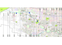
Blue diamonds mark the location of regional flood control detention basins that are being built as a part of Project Brays. Note: (Willow Waterhole Detention Basin is off the sheet to the south of Braeswood to Chimney Rock Channel, Reach 110). Regional and neighborhood parks along Brays Bayou are colored in bright green and other open spaces such as cemeteries and golf courses are shown in pale green. Major bridges that cross the bayou are indicated by red colored rectangle and bicycle bridges are shown with thinner red rectangles.
As a community-based effort to leverage the work being done by Project Brays along the channel, partnership enhancements will be adopted and implemented by many communities or institutional organizations.

