«previous pageANALYSIS & PLANNING CATEGORY
Honor Award
Brooklyn Bridge Park, Brooklyn, NY
Michael Van Valkenburgh Associates, Inc., Brooklyn, NY
client: Brooklyn Bridge Park Development Corporation
Project Statement
The 2005 Master Plan for Brooklyn Bridge Park proposes a framework for bringing sociological diversity, programmatic flexibility, and psychological range to a beautiful but environmentally hostile abandoned cargo shipping facility in Brooklyn. Fluently integrating multiple project goals of experiential complexity, environmental sustainability, economic efficiency, urban connectivity, and social vibrancy, the project significantly expanded the scope of responsibilities of the landscape architect in the design of urban environments.
Project Narrative
How Do You Build Brooklyn Bridge Park?
The 2005 Master Plan for Brooklyn Bridge Park is a landscape-architect led effort that sets forth an integrated design methodology for transforming a derelict industrial waterfront into a socially and ecologically active urban park. Firmly grounded in an understanding of the metrics of the site's challenges (contamination, structural limitations, isolation, extreme noise pollution, harsh winds, and blistering sun), the Master Plan lays the groundwork to create a new civic space in one of New York City's most astoundingly beautiful locations: an 85-acre site which occupies 1.3 miles of Brooklyn waterfront, passes underneath two major bridges, and includes a series of mammoth industrial piers, each 5 acres in area. The Master Plan was the first phase in the design team's commission to plan, design, detail, and build Brooklyn Bridge Park.
The goal of the community interest groups, state and city officials, and designers involved in the development of the Brooklyn Bridge Park Master Plan was ambitious but fairly straightforward: to allow the site's emotional power and intensity to resonate in a new ecologically, socially, and economically sustainable park setting. The authors of the Master Plan recognized that the park's greatest experiential asset was its location at a highly dynamic edge where three different but co-dependent ecosystems — river, harbor, and city — merge. The existing site was largely flat and paved but it was also located within the context of some of the city's most powerful historic and natural landmarks, including sweeping views to lower Manhattan, just across the East River. The various microclimatic challenges identified through extensive environmental analysis included uncomfortably high decibel noise pollution generated from the elevated highway, strong winter winds from the harbor, and extreme sun exposure due to the lack of shade; fundamental environmental transformations would be necessary before this location could provide the physical conditions that would support enough human comfort to ensure a successful park program.
Social Accessibility
Site analysis demonstrated that the biggest social challenge was the task of bringing a diverse range of people into the park — the long, narrow site had historically been isolated by virtue of its industrial use and due to the presence of a multi-level elevated highway that bounds much of the site to the east and severs the closest adjacent neighborhood from any park access. Street-level entry from the adjacent neighborhoods of Cobble Hill, Boerum Hill, DUMBO, and Brooklyn Heights was possible in just three locations: at Atlantic Avenue, Fulton Ferry Landing, and John Street. To combat this isolation, strategic programming was proposed to establish a strong city-park relationship at each entrance and to implement a group of ideas that were described under the title "urban junctions." The entries would be important moments of interchange where the city would usher people into the park. Urban promenades, dog runs, neighborhood scale playgrounds and generous public spaces were proposed at these park entries, while organized sports, a private marina for small boats, and event-scale spaces for the city at large were located further into the depth of the park where pedestrian access was less immediate. A broad selection of water-oriented programs, including fishing piers, water taxi access, the marina, a boat launch, a calm-water zone for kayaking, and a beach were proposed as a means of emphasizing the unique location of the park.
Economic Self-Sufficiency
The planning and design team also had an unusual opportunity to shape the city side of the urban junction. Rather than operate within city or state park maintenance budgets, the economic engine for funding park operations, maintenance, and repairs was to be developed as part of the park. The original legislation creating the park stipulated that up to 20% of the 85-acre project site could be designated as development areas rather than public open space. The design team was dedicated to the idea that the development would be as small as possible while still producing adequate revenues, and that its program, form, and location would serve the interests of the park, rather than the other way around. Extensive research and analysis were undertaken by the planning team to predict the annual maintenance costs of the proposed park as well as the income stream from the proposed park edge development. A heuristic design process in which the type, size, and location of the development, the massing of the buildings, the interface with the park, the design of the park with respect to the need for ongoing maintenance, and the relationship with adjacent neighborhoods became the variables that could be adjusted in search of a bottom line that would match park revenue with projected maintenance and operations budget needs, allowing a more precise economic model that limited the commercial development to just 9% of the project site, less than half of what it might have been.
Environmental Performance
An essential first step in planning for sustainable construction was to identify opportunities for "structural economy," a term that was applied to numerous site-planning strategies. To start with, the Master Plan recommends preserving and reusing as much of the existing marine structure as possible. Different areas of the park were better suited to particular kinds of use; for instance, the upland areas and Pier 1 (which is more of a peninsula than a pier) could support deeper soils and hence more tree cover. The big cargo-shipping piers had less structural capacity and could support lighter, shallower program without extensive reinforcing. This principle of resourcefulness also inspired the reuse of portions of the large pier sheds as well as the extensive reuse of materials that were salvaged from demolished buildings and structures, some onsite, others from elsewhere in New York City.
Ecological Restoration
With respect to site ecology, the park planners explored a number of initiatives grouped under the term of "post-industrial nature" that were aimed at re-establishing a series of functioning ecosystems on the currently lifeless site. The combined planting and stormwater treatment strategy for Brooklyn Bridge Park is founded on four guiding principles: to create many different natural areas that serve individually as gardens but work together to establish a new site ecology; to treat as much stormwater as possible onsite; to maximize area of shade and cover from the wind, and to preserve open space. Natural habitats being reintroduced to the site include coastal shrublands, freshwater wetlands, coastal forest, a wildflower meadow, a marsh, and shallow water habitats.
Microclimate and Human Comfort
Natural plantings also have the potential to make the site more hospitable as human habitat. The dispersal of planting that is suggested throughout the site will be coordinated with solar orientation and wind protection to maximize human comfort. Depending on the season, or the particular site-related issue, different needs are accommodated through different park elements: a nearly continuous meander and hedgerow of trees running north-south will provide shade and relief from the intense summer afternoon sun that reflects off the water; the topography and buildings provide protected sun exposure in the winter and shelter from the wind in different ways and from different directions; and tall hills absorb the tremendous noise generated by the Brooklyn-Queens Expressway, making the park quieter and more pleasant while also providing new elevated views to the harbor.
The 2005 Brooklyn Bridge Park Master Plan synthesizes the many variables of the park existing conditions and future aspirations and gives them all a voice. A landscape-based understanding of the powerful experience of the vast openness of the harbor and views to the Manhattan skyline are combined with a resourceful approach to the pragmatics of construction, ecology, and economics to establish a profound experiential framework for the new park. Unique by virtue of the complexity of the site and the extraordinary urban design tools put at the disposal of the landscape architect, the Master Plan offers a model for integrated design and transformative change inspired by the found qualities of the site.
Project Resources
Cost Estimating
Accu-Coast Construction
Architecture
Architecture Research Office
James Carpenter Design Associates
Maryann Thompson Architects
Infrastructural Engineers
Henry Bardsley, RFR
Environmental Engineers
Battle McCarthy
Acoustical Engineers
Cerami Associates
Government & Community Relations
Constructive Strategies
Urban Design
Cooper, Robertson & Partners
Marine, Civil and MEP Engineers
DMJM + Harris
Risk and Protection
Ducibella Venter & Santore
Transportation Planners
Eng-Wong Taub & Associates
Economic Consultant
Susan Fine
Architecture and Conditions Surveyors
Gensler
Lighting Design
Domingo Gonzalez Associates, Inc.
Ecologist
Steven Handel
Planner
Jerold Kayden
Hotel Consultant
Lodging Investments Advisors, LLC
Landscape Architects
Mathew Nielsen Landscape Architects
Graphic Design
OPEN and Pentagram Design
Ecological Landscape Planning
Margie Ruddick Landscape
Structural Engineer
Ysrael A. Seinuk, PC
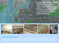
The Brooklyn Bridge Part site is comprised of 85 acres of formerly industrial waterfront parcels. The construction of several systems of piles, platforms, of earth filling, and pavement over the course of 200 year destroyed the natural shoreline. In addition, large urban infrastructure, such as the Brooklyn-Queens Expressway, built during the last century severed connections between the waterfront and the everyday life of the city. In a process that will partially reverse the effects of the industrialization of the river's edge, Brooklyn Bridge Park will reintroduce ecological systems on the site and reconnect the river to the city. (Photo: MVVA)
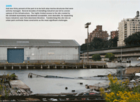
2005 Just over thirty percent of the park is to be built atop marine structures that were actively managed. Several decades of dwindling industrial use led to uneven upkeep of this infrastructure. The highly limited access to the site created by the elevated expressway was deemed acceptable, even desirable, for separating heavy industrial uses from downtown Brooklyn. Transforming this site into an urban park confronts these constraints as the most significant challenges. (Photo: Elizabeth Felicella)
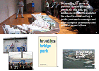
Succeeding 25 years of previous master planning efforts for this site, the landscape architects assisted the client in constructing a public process to manage and align complex community and political expectations. (Photo: MVVA; Bottom-left — Scott Stowell)

Rendering of Pier 2 Upland. (Photo: MVVA; Upper-left — Scott Stowell)
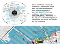
Urban waterfronts accumulate complexity. The Brooklyn Bridge Park site has to accommodate both the program needs of the Park Constituency and maintain an extensive amount of infrastructural functions for the city as a whole; while engaging in jurisdictions that extend well beyond the site boundaries. (Photo: MVVA)
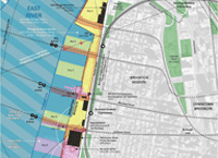
Map of Infrastructural Functions and Property Ownership. (Photo: MVVA)
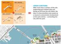
Urban Junctions After more than a century of the site supporting port related uses and being cut off from the city fabric, the idea of urban junctions was posed as a means to concentrate development at the park entries - connecting the city with the park. (Photo: MVVA)

Urban Junctions and Park Design. (Photo: MVVA)
"Inventive, amazingly clear, and concise. This project is quite significant to the public realm, natural resources, and environmental planning. It uses a wide range of tools to solve urban problems and does a great job of communicating the ecological and social components to the public. "
— 2009 Professional Awards Jury
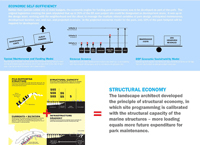
Structural Economy The landscape architect developed the principle of structural economy, in which site programming is calibrated with the structural capacity of the marine structures — more loading equals more future expenditure for park maintenance. (Photo: MVVA)

Park Programming The location of the park recreational program will be in direct response to varying structural capacities of the site. Activities that do no add significant weight loads, such as field sports, will be located on the piers. Activities that add considerable loads to the ground will be located on terra firma. (Photo: MVVA)
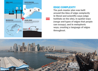
Edge Complexity The park master plan was built around the idea of edge complexity in literal and scientific ways (edge habitats on the site), in spatial ways (range and types of edges that people can occupy), and in metaphoric ways, creating a language of edges throughout. (Photo: Jerry Speier)
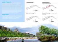
Rocky Beach and Habitat Island at Pier 4. (Photo: MVVA)

Micro-Climate and Form The site is exposed to a great deal of environmental forces: high solar and wind exposure, uncomfortable noise levels from the adjacent expressway, river currents, wakes, and sedimentation. The physical composition of the park proposes an inseparable link between micro-climate and form. (Photo: MVVA)
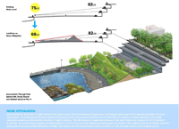
Noise Attenuation Interrupting the direct line of sight between the noise source (Brooklyn-Queens Expressway) and listener (park user) is the general principle for sound attenuation. Considering the Brooklyn-Queens Expressway (line noise source) and the use of earth hills as a barrier, a noise reduction of 5 to 8dB (decibels) would be achieved when the line of sight is broken. The difference of magnitude between 1 bel and 2 bels is by a power of 10 (1 Decibel=1/10 bel). An incremental reduction of 6dB results in ½ x ½ (1/4) of the original acoustic power. Example: if the original sound was 66dB, and after attenuation it became 60dB (difference of 6dB), this means that the attenuated sound is actually ¼ the acoustic power of the original sound. (Photo: MVVA)
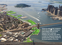
Unique by virtue of the complexity of the site and the extraordinary urban design tools put at the disposal of the landscape architect, the master plan offers a model for integrated design and transformative change inspired by the found qualities of the site. (Photo: MVVA)


